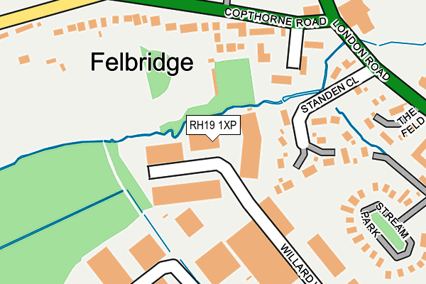
RH19 1XP is located in the East Grinstead Imberhorne electoral ward, within the local authority district of Mid Sussex and the English Parliamentary constituency of Mid Sussex. The Sub Integrated Care Board (ICB) Location is NHS Sussex ICB - 70F and the police force is Sussex. This postcode has been in use since August 1992.


GetTheData
Source: OS OpenMap – Local (Ordnance Survey)
Source: OS VectorMap District (Ordnance Survey)
Licence: Open Government Licence (requires attribution)
| Easting | 537143 |
| Northing | 139465 |
| Latitude | 51.138039 |
| Longitude | -0.041083 |
GetTheData
Source: Open Postcode Geo
Licence: Open Government Licence
| Country | England |
| Postcode District | RH19 |
| ➜ RH19 open data dashboard ➜ See where RH19 is on a map ➜ Where is East Grinstead? | |
GetTheData
Source: Land Registry Price Paid Data
Licence: Open Government Licence
Elevation or altitude of RH19 1XP as distance above sea level:
| Metres | Feet | |
|---|---|---|
| Elevation | 90m | 295ft |
Elevation is measured from the approximate centre of the postcode, to the nearest point on an OS contour line from OS Terrain 50, which has contour spacing of ten vertical metres.
➜ How high above sea level am I? Find the elevation of your current position using your device's GPS.
GetTheData
Source: Open Postcode Elevation
Licence: Open Government Licence
| Ward | East Grinstead Imberhorne |
| Constituency | Mid Sussex |
GetTheData
Source: ONS Postcode Database
Licence: Open Government Licence
| June 2022 | Violence and sexual offences | On or near Sports/Recreation Area | 418m |
| May 2022 | Vehicle crime | On or near The Moorings | 147m |
| May 2022 | Vehicle crime | On or near The Moorings | 147m |
| ➜ Get more crime data in our Crime section | |||
GetTheData
Source: data.police.uk
Licence: Open Government Licence
| The Star Inn (Copthorne Road) | Felbridge | 181m |
| The Star Inn (Copthorne Road) | Felbridge | 191m |
| The Star Inn (Eastbourne Road) | Felbridge | 253m |
| The Star Inn (Eastbourne Road) | Felbridge | 293m |
| Felbridge Hotel (London Road) | East Grinstead | 329m |
| East Grinstead Station | 2.1km |
| Dormans Station | 3.2km |
| Lingfield Station | 4.9km |
GetTheData
Source: NaPTAN
Licence: Open Government Licence
GetTheData
Source: ONS Postcode Database
Licence: Open Government Licence


➜ Get more ratings from the Food Standards Agency
GetTheData
Source: Food Standards Agency
Licence: FSA terms & conditions
| Last Collection | |||
|---|---|---|---|
| Location | Mon-Fri | Sat | Distance |
| Crawley Down Road East | 16:45 | 09:15 | 381m |
| Lowdells Lane | 17:15 | 12:00 | 1,506m |
| The Grange | 16:30 | 09:30 | 1,914m |
GetTheData
Source: Dracos
Licence: Creative Commons Attribution-ShareAlike
| Facility | Distance |
|---|---|
| Chartham Ground London Road, Felbridge Grass Pitches | 304m |
| Chakra Spa London Road, East Grinstead Health and Fitness Gym, Swimming Pool, Outdoor Tennis Courts | 354m |
| Imberhorne Upper School Imberhorne Lane, East Grinstead Grass Pitches, Sports Hall, Athletics, Outdoor Tennis Courts, Studio, Health and Fitness Gym | 615m |
GetTheData
Source: Active Places
Licence: Open Government Licence
| School | Phase of Education | Distance |
|---|---|---|
| Felbridge Primary School Crawley Down Road, Felbridge, East Grinstead, RH19 2NT | Primary | 400m |
| Imberhorne School Imberhorne Lane, East Grinstead, RH19 1QY | Secondary | 608m |
| Halsford Park Primary School Manor Road, East Grinstead, RH19 1LR | Primary | 1.2km |
GetTheData
Source: Edubase
Licence: Open Government Licence
The below table lists the International Territorial Level (ITL) codes (formerly Nomenclature of Territorial Units for Statistics (NUTS) codes) and Local Administrative Units (LAU) codes for RH19 1XP:
| ITL 1 Code | Name |
|---|---|
| TLJ | South East (England) |
| ITL 2 Code | Name |
| TLJ2 | Surrey, East and West Sussex |
| ITL 3 Code | Name |
| TLJ28 | West Sussex (North East) |
| LAU 1 Code | Name |
| E07000228 | Mid Sussex |
GetTheData
Source: ONS Postcode Directory
Licence: Open Government Licence
The below table lists the Census Output Area (OA), Lower Layer Super Output Area (LSOA), and Middle Layer Super Output Area (MSOA) for RH19 1XP:
| Code | Name | |
|---|---|---|
| OA | E00161836 | |
| LSOA | E01031740 | Mid Sussex 004E |
| MSOA | E02006607 | Mid Sussex 004 |
GetTheData
Source: ONS Postcode Directory
Licence: Open Government Licence
| RH19 2LJ | Mulberry Gate | 137m |
| RH19 2RL | Standen Close | 147m |
| RH19 2NP | Felbridge Court | 169m |
| RH19 2NJ | Longwall | 171m |
| RH19 2NR | Copthorne Road | 175m |
| RH19 2TD | The Moorings | 188m |
| RH19 2NS | Copthorne Road | 257m |
| RH19 2QL | The Feld | 270m |
| RH19 1QN | Stream Park | 289m |
| RH19 2NT | Crawley Down Road | 313m |
GetTheData
Source: Open Postcode Geo; Land Registry Price Paid Data
Licence: Open Government Licence