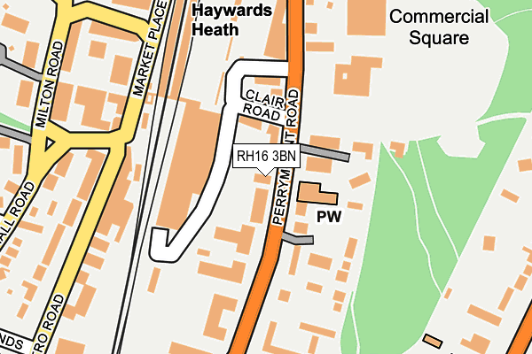
RH16 3BN lies on Perrymount Road in Haywards Heath. RH16 3BN is located in the Haywards Heath Bentswood & Heath electoral ward, within the local authority district of Mid Sussex and the English Parliamentary constituency of Mid Sussex. The Sub Integrated Care Board (ICB) Location is NHS Sussex ICB - 70F and the police force is Sussex. This postcode has been in use since January 1980.


GetTheData
Source: OS OpenMap – Local (Ordnance Survey)
Source: OS VectorMap District (Ordnance Survey)
Licence: Open Government Licence (requires attribution)
| Easting | 533143 |
| Northing | 124559 |
| Latitude | 51.005015 |
| Longitude | -0.103681 |
GetTheData
Source: Open Postcode Geo
Licence: Open Government Licence
| Street | Perrymount Road |
| Town/City | Haywards Heath |
| Country | England |
| Postcode District | RH16 |
| ➜ RH16 open data dashboard ➜ See where RH16 is on a map ➜ Where is Haywards Heath? | |
GetTheData
Source: Land Registry Price Paid Data
Licence: Open Government Licence
Elevation or altitude of RH16 3BN as distance above sea level:
| Metres | Feet | |
|---|---|---|
| Elevation | 60m | 197ft |
Elevation is measured from the approximate centre of the postcode, to the nearest point on an OS contour line from OS Terrain 50, which has contour spacing of ten vertical metres.
➜ How high above sea level am I? Find the elevation of your current position using your device's GPS.
GetTheData
Source: Open Postcode Elevation
Licence: Open Government Licence
| Ward | Haywards Heath Bentswood & Heath |
| Constituency | Mid Sussex |
GetTheData
Source: ONS Postcode Database
Licence: Open Government Licence
| January 2024 | Violence and sexual offences | On or near Perrymount Road | 180m |
| January 2024 | Other theft | On or near Perrymount Road | 180m |
| January 2024 | Violence and sexual offences | On or near Perrymount Road | 180m |
| ➜ Perrymount Road crime map and outcomes | |||
GetTheData
Source: data.police.uk
Licence: Open Government Licence
| Perrymount Road | Haywards Heath | 47m |
| Perrymount Road | Haywards Heath | 49m |
| Railway Station (Market Place) | Haywards Heath | 115m |
| Market Square (Market Place) | Haywards Heath | 152m |
| Sainsbury's (Bannister Way) | Haywards Heath | 232m |
| Haywards Heath Station | 0.1km |
| Wivelsfield Station | 4.7km |
GetTheData
Source: NaPTAN
Licence: Open Government Licence
GetTheData
Source: ONS Postcode Database
Licence: Open Government Licence


➜ Get more ratings from the Food Standards Agency
GetTheData
Source: Food Standards Agency
Licence: FSA terms & conditions
| Last Collection | |||
|---|---|---|---|
| Location | Mon-Fri | Sat | Distance |
| Haywards Heath Station | 122m | ||
| Haywards Heath D O | 18:30 | 12:45 | 163m |
| Sainsburys | 16:00 | 11:30 | 232m |
GetTheData
Source: Dracos
Licence: Creative Commons Attribution-ShareAlike
| Facility | Distance |
|---|---|
| Haywards Heath Recreation Ground Perrymount Road, Haywards Heath Grass Pitches | 186m |
| The Dolphin Pasture Hill Road, Haywards Heath Sports Hall, Swimming Pool, Health and Fitness Gym, Studio, Squash Courts | 481m |
| Central Sussex College (Haywards Heath Campus) (Closed) Harlands Road, Haywards Heath Health and Fitness Gym, Grass Pitches, Sports Hall | 623m |
GetTheData
Source: Active Places
Licence: Open Government Licence
| School | Phase of Education | Distance |
|---|---|---|
| Central Education Ltd Yew Tree Farm, Nash Lane, Scaynes Hill, Haywards Heath, RH17 7NJ | Not applicable | 189m |
| Warden Park Primary Academy New England Road, Haywards Heath, RH16 3JR | Primary | 728m |
| Oathall Community College Appledore Gardens, Lindfield, Haywards Heath, RH16 2AQ | Secondary | 816m |
GetTheData
Source: Edubase
Licence: Open Government Licence
The below table lists the International Territorial Level (ITL) codes (formerly Nomenclature of Territorial Units for Statistics (NUTS) codes) and Local Administrative Units (LAU) codes for RH16 3BN:
| ITL 1 Code | Name |
|---|---|
| TLJ | South East (England) |
| ITL 2 Code | Name |
| TLJ2 | Surrey, East and West Sussex |
| ITL 3 Code | Name |
| TLJ28 | West Sussex (North East) |
| LAU 1 Code | Name |
| E07000228 | Mid Sussex |
GetTheData
Source: ONS Postcode Directory
Licence: Open Government Licence
The below table lists the Census Output Area (OA), Lower Layer Super Output Area (LSOA), and Middle Layer Super Output Area (MSOA) for RH16 3BN:
| Code | Name | |
|---|---|---|
| OA | E00161946 | |
| LSOA | E01031761 | Mid Sussex 009C |
| MSOA | E02006612 | Mid Sussex 009 |
GetTheData
Source: ONS Postcode Directory
Licence: Open Government Licence
| RH16 3DP | Clair Road | 29m |
| RH16 3DR | Perrymount Road | 36m |
| RH16 3BA | Perrymount Road | 60m |
| RH16 1DW | Commercial Square | 81m |
| RH16 1DP | Commercial Square | 91m |
| RH16 1PY | Sydney Road | 123m |
| RH16 3DN | Perrymount Road | 134m |
| RH16 1QQ | Sydney Road | 152m |
| RH16 1PZ | Sydney Road | 157m |
| RH16 3EE | Perrymount Road | 173m |
GetTheData
Source: Open Postcode Geo; Land Registry Price Paid Data
Licence: Open Government Licence