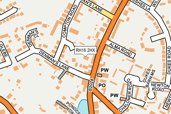
RH16 2HX lies on High Street in Lindfield, Haywards Heath. RH16 2HX is located in the Lindfield electoral ward, within the local authority district of Mid Sussex and the English Parliamentary constituency of Mid Sussex. The Sub Integrated Care Board (ICB) Location is NHS Sussex ICB - 70F and the police force is Sussex. This postcode has been in use since September 1981.


GetTheData
Source: OS OpenMap – Local (Ordnance Survey)
Source: OS VectorMap District (Ordnance Survey)
Licence: Open Government Licence (requires attribution)
| Easting | 534661 |
| Northing | 125489 |
| Latitude | 51.013024 |
| Longitude | -0.081740 |
GetTheData
Source: Open Postcode Geo
Licence: Open Government Licence
| Street | High Street |
| Locality | Lindfield |
| Town/City | Haywards Heath |
| Country | England |
| Postcode District | RH16 |
| ➜ RH16 open data dashboard ➜ See where RH16 is on a map ➜ Where is Haywards Heath? | |
GetTheData
Source: Land Registry Price Paid Data
Licence: Open Government Licence
Elevation or altitude of RH16 2HX as distance above sea level:
| Metres | Feet | |
|---|---|---|
| Elevation | 40m | 131ft |
Elevation is measured from the approximate centre of the postcode, to the nearest point on an OS contour line from OS Terrain 50, which has contour spacing of ten vertical metres.
➜ How high above sea level am I? Find the elevation of your current position using your device's GPS.
GetTheData
Source: Open Postcode Elevation
Licence: Open Government Licence
| Ward | Lindfield |
| Constituency | Mid Sussex |
GetTheData
Source: ONS Postcode Database
Licence: Open Government Licence
57, HIGH STREET, LINDFIELD, HAYWARDS HEATH, RH16 2HX 2002 27 MAR £87,000 |
GetTheData
Source: HM Land Registry Price Paid Data
Licence: Contains HM Land Registry data © Crown copyright and database right 2024. This data is licensed under the Open Government Licence v3.0.
| December 2023 | Criminal damage and arson | On or near Parking Area | 43m |
| August 2023 | Violence and sexual offences | On or near Parking Area | 43m |
| June 2022 | Drugs | On or near Parking Area | 43m |
| ➜ High Street crime map and outcomes | |||
GetTheData
Source: data.police.uk
Licence: Open Government Licence
| Post Office (High Street) | Lindfield | 59m |
| Post Office (High Street) | Lindfield | 78m |
| Lindfield Common (Black Hill) | Haywards Heath | 311m |
| Lindfield Common (Black Hill) | Haywards Heath | 330m |
| Playing Field (Hickman's Lane) | Haywards Heath | 340m |
| Haywards Heath Station | 1.8km |
| Balcombe Station | 6.1km |
GetTheData
Source: NaPTAN
Licence: Open Government Licence
GetTheData
Source: ONS Postcode Database
Licence: Open Government Licence


➜ Get more ratings from the Food Standards Agency
GetTheData
Source: Food Standards Agency
Licence: FSA terms & conditions
| Last Collection | |||
|---|---|---|---|
| Location | Mon-Fri | Sat | Distance |
| Sunte Avenue P O | 17:30 | 12:00 | 718m |
| Summerhill Lane | 17:15 | 12:00 | 939m |
| Appledore Gardens | 17:30 | 11:15 | 969m |
GetTheData
Source: Dracos
Licence: Creative Commons Attribution-ShareAlike
| Facility | Distance |
|---|---|
| Hickmans Lane Hickmans Lane, Lindfield, Haywards Heath Grass Pitches | 336m |
| Lindfield Common Lewes Road, Lindfield, Haywards Heath Grass Pitches, Outdoor Tennis Courts | 406m |
| Lindfield Primary Academy School Lane, Lindfield, Haywards Heath Artificial Grass Pitch, Grass Pitches | 418m |
GetTheData
Source: Active Places
Licence: Open Government Licence
| School | Phase of Education | Distance |
|---|---|---|
| Lindfield Primary Academy School Lane, Lindfield, Haywards Heath, RH16 2DX | Primary | 398m |
| Blackthorns Community Primary Academy 3 Blackthorns Close, Lindfield, Haywards Heath, RH16 2UA | Primary | 653m |
| Oathall Community College Appledore Gardens, Lindfield, Haywards Heath, RH16 2AQ | Secondary | 1km |
GetTheData
Source: Edubase
Licence: Open Government Licence
The below table lists the International Territorial Level (ITL) codes (formerly Nomenclature of Territorial Units for Statistics (NUTS) codes) and Local Administrative Units (LAU) codes for RH16 2HX:
| ITL 1 Code | Name |
|---|---|
| TLJ | South East (England) |
| ITL 2 Code | Name |
| TLJ2 | Surrey, East and West Sussex |
| ITL 3 Code | Name |
| TLJ28 | West Sussex (North East) |
| LAU 1 Code | Name |
| E07000228 | Mid Sussex |
GetTheData
Source: ONS Postcode Directory
Licence: Open Government Licence
The below table lists the Census Output Area (OA), Lower Layer Super Output Area (LSOA), and Middle Layer Super Output Area (MSOA) for RH16 2HX:
| Code | Name | |
|---|---|---|
| OA | E00162021 | |
| LSOA | E01031772 | Mid Sussex 008C |
| MSOA | E02006611 | Mid Sussex 008 |
GetTheData
Source: ONS Postcode Directory
Licence: Open Government Licence
| RH16 2LB | Denmans Lane | 33m |
| RH16 2HN | High Street | 34m |
| RH16 2HL | High Street | 54m |
| RH16 2LA | Denmans Lane | 85m |
| RH16 2JZ | Compton Road | 102m |
| RH16 2HW | Alma Road | 109m |
| RH16 2HJ | High Street | 112m |
| RH16 2LE | Lewes Road | 137m |
| RH16 2JY | Compton Road | 152m |
| RH16 2HP | High Street | 162m |
GetTheData
Source: Open Postcode Geo; Land Registry Price Paid Data
Licence: Open Government Licence