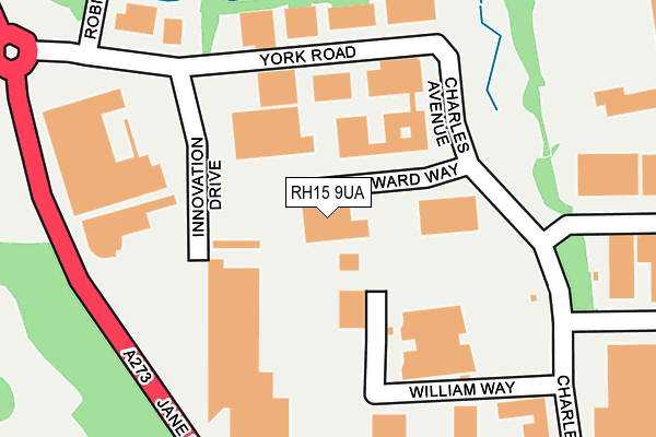
RH15 9UA is located in the Burgess Hill Victoria electoral ward, within the local authority district of Mid Sussex and the English Parliamentary constituency of Mid Sussex. The Sub Integrated Care Board (ICB) Location is NHS Sussex ICB - 70F and the police force is Sussex. This postcode has been in use since August 2010.


GetTheData
Source: OS OpenMap – Local (Ordnance Survey)
Source: OS VectorMap District (Ordnance Survey)
Licence: Open Government Licence (requires attribution)
| Easting | 529799 |
| Northing | 118682 |
| Latitude | 50.952963 |
| Longitude | -0.153439 |
GetTheData
Source: Open Postcode Geo
Licence: Open Government Licence
| Country | England |
| Postcode District | RH15 |
| ➜ RH15 open data dashboard ➜ See where RH15 is on a map ➜ Where is Burgess Hill? | |
GetTheData
Source: Land Registry Price Paid Data
Licence: Open Government Licence
Elevation or altitude of RH15 9UA as distance above sea level:
| Metres | Feet | |
|---|---|---|
| Elevation | 30m | 98ft |
Elevation is measured from the approximate centre of the postcode, to the nearest point on an OS contour line from OS Terrain 50, which has contour spacing of ten vertical metres.
➜ How high above sea level am I? Find the elevation of your current position using your device's GPS.
GetTheData
Source: Open Postcode Elevation
Licence: Open Government Licence
| Ward | Burgess Hill Victoria |
| Constituency | Mid Sussex |
GetTheData
Source: ONS Postcode Database
Licence: Open Government Licence
| November 2023 | Anti-social behaviour | On or near Blackbird Close | 383m |
| July 2023 | Violence and sexual offences | On or near Blackbird Close | 383m |
| January 2023 | Public order | On or near Blackbird Close | 383m |
| ➜ Get more crime data in our Crime section | |||
GetTheData
Source: data.police.uk
Licence: Open Government Licence
| Edward Way (Charles Avenue) | Burgess Hill | 138m |
| Edward Way (Charles Avenue) | Burgess Hill | 158m |
| Innovation Drive (York Road) | Burgess Hill | 178m |
| Innovation Drive (York Road) | Burgess Hill | 184m |
| The Acorn (Charles Avenue) | Burgess Hill | 269m |
| Burgess Hill Station | 1.8km |
| Wivelsfield Station | 2.6km |
| Hassocks Station | 3.2km |
GetTheData
Source: NaPTAN
Licence: Open Government Licence
GetTheData
Source: ONS Postcode Database
Licence: Open Government Licence


➜ Get more ratings from the Food Standards Agency
GetTheData
Source: Food Standards Agency
Licence: FSA terms & conditions
| Last Collection | |||
|---|---|---|---|
| Location | Mon-Fri | Sat | Distance |
| Burgess Hill Delivery Office | 18:30 | 12:00 | 154m |
| Tesco Superstore | 18:15 | 11:30 | 442m |
| Victoria Way | 18:30 | 838m | |
GetTheData
Source: Dracos
Licence: Creative Commons Attribution-ShareAlike
| Facility | Distance |
|---|---|
| Southway Recreation Ground Poveys Close, Burgess Hill Grass Pitches | 593m |
| Southway Junior School Southway, Burgess Hill Swimming Pool, Grass Pitches | 612m |
| Fairfield Recreation Ground (Burgess Hill) Fairfield Road, Burgess Hill Grass Pitches | 966m |
GetTheData
Source: Active Places
Licence: Open Government Licence
| School | Phase of Education | Distance |
|---|---|---|
| Southway Junior School Southway, Burgess Hill, RH15 9SU | Primary | 615m |
| The Gattons Infant School Royal George Road, Burgess Hill, RH15 9SL | Primary | 842m |
| St Wilfrid's Catholic Primary School, Burgess Hill School Close, Queen Elizabeth Avenue, Burgess Hill, RH15 9RJ | Primary | 1.2km |
GetTheData
Source: Edubase
Licence: Open Government Licence
The below table lists the International Territorial Level (ITL) codes (formerly Nomenclature of Territorial Units for Statistics (NUTS) codes) and Local Administrative Units (LAU) codes for RH15 9UA:
| ITL 1 Code | Name |
|---|---|
| TLJ | South East (England) |
| ITL 2 Code | Name |
| TLJ2 | Surrey, East and West Sussex |
| ITL 3 Code | Name |
| TLJ28 | West Sussex (North East) |
| LAU 1 Code | Name |
| E07000228 | Mid Sussex |
GetTheData
Source: ONS Postcode Directory
Licence: Open Government Licence
The below table lists the Census Output Area (OA), Lower Layer Super Output Area (LSOA), and Middle Layer Super Output Area (MSOA) for RH15 9UA:
| Code | Name | |
|---|---|---|
| OA | E00161718 | |
| LSOA | E01031714 | Mid Sussex 012D |
| MSOA | E02006615 | Mid Sussex 012 |
GetTheData
Source: ONS Postcode Directory
Licence: Open Government Licence
| RH15 9RY | Charles Avenue | 148m |
| RH15 9AD | York Road | 186m |
| RH15 9AG | William Way | 207m |
| RH15 9DL | Skylark Way | 259m |
| RH15 9DW | Goldfinch Road | 292m |
| RH15 9DH | Siskin Close | 295m |
| RH15 9BF | Linnet Lane | 311m |
| RH15 9EE | Brambling Way | 337m |
| RH15 9XX | Robin Road | 342m |
| RH15 9XY | Woodpecker Crescent | 402m |
GetTheData
Source: Open Postcode Geo; Land Registry Price Paid Data
Licence: Open Government Licence