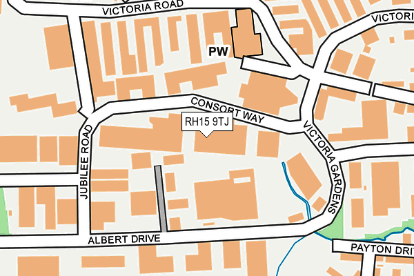
RH15 9TJ lies on Consort Way in Burgess Hill. RH15 9TJ is located in the Burgess Hill Victoria electoral ward, within the local authority district of Mid Sussex and the English Parliamentary constituency of Mid Sussex. The Sub Integrated Care Board (ICB) Location is NHS Sussex ICB - 70F and the police force is Sussex. This postcode has been in use since September 1981.


GetTheData
Source: OS OpenMap – Local (Ordnance Survey)
Source: OS VectorMap District (Ordnance Survey)
Licence: Open Government Licence (requires attribution)
| Easting | 530244 |
| Northing | 118805 |
| Latitude | 50.953963 |
| Longitude | -0.147036 |
GetTheData
Source: Open Postcode Geo
Licence: Open Government Licence
| Street | Consort Way |
| Town/City | Burgess Hill |
| Country | England |
| Postcode District | RH15 |
| ➜ RH15 open data dashboard ➜ See where RH15 is on a map ➜ Where is Burgess Hill? | |
GetTheData
Source: Land Registry Price Paid Data
Licence: Open Government Licence
Elevation or altitude of RH15 9TJ as distance above sea level:
| Metres | Feet | |
|---|---|---|
| Elevation | 30m | 98ft |
Elevation is measured from the approximate centre of the postcode, to the nearest point on an OS contour line from OS Terrain 50, which has contour spacing of ten vertical metres.
➜ How high above sea level am I? Find the elevation of your current position using your device's GPS.
GetTheData
Source: Open Postcode Elevation
Licence: Open Government Licence
| Ward | Burgess Hill Victoria |
| Constituency | Mid Sussex |
GetTheData
Source: ONS Postcode Database
Licence: Open Government Licence
| June 2022 | Criminal damage and arson | On or near Victoria Road | 161m |
| June 2022 | Other theft | On or near Jubilee Road | 207m |
| June 2022 | Burglary | On or near Knowles Walk | 370m |
| ➜ Consort Way crime map and outcomes | |||
GetTheData
Source: data.police.uk
Licence: Open Government Licence
| Sovereign Business Park (Albert Drive) | Burgess Hill | 203m |
| Sovereign Business Park (Albert Drive) | Burgess Hill | 222m |
| Consort Way (Victoria Gardens) | Burgess Hill | 229m |
| Consort Way (Victoria Gardens) | Burgess Hill | 235m |
| Jubilee Road (Albert Drive) | Burgess Hill | 254m |
| Burgess Hill Station | 1.4km |
| Wivelsfield Station | 2.2km |
| Hassocks Station | 3.3km |
GetTheData
Source: NaPTAN
Licence: Open Government Licence
GetTheData
Source: ONS Postcode Database
Licence: Open Government Licence


➜ Get more ratings from the Food Standards Agency
GetTheData
Source: Food Standards Agency
Licence: FSA terms & conditions
| Last Collection | |||
|---|---|---|---|
| Location | Mon-Fri | Sat | Distance |
| Victoria Way | 18:30 | 378m | |
| Tesco Superstore | 18:15 | 11:30 | 457m |
| Burgess Hill Delivery Office | 18:30 | 12:00 | 521m |
GetTheData
Source: Dracos
Licence: Creative Commons Attribution-ShareAlike
| Facility | Distance |
|---|---|
| Southway Junior School Southway, Burgess Hill Swimming Pool, Grass Pitches | 549m |
| Puregym (Burgess Hill) London Road, Burgess Hill Health and Fitness Gym | 639m |
| Southway Recreation Ground Poveys Close, Burgess Hill Grass Pitches | 664m |
GetTheData
Source: Active Places
Licence: Open Government Licence
| School | Phase of Education | Distance |
|---|---|---|
| Southway Junior School Southway, Burgess Hill, RH15 9SU | Primary | 565m |
| The Gattons Infant School Royal George Road, Burgess Hill, RH15 9SL | Primary | 576m |
| St Wilfrid's Catholic Primary School, Burgess Hill School Close, Queen Elizabeth Avenue, Burgess Hill, RH15 9RJ | Primary | 722m |
GetTheData
Source: Edubase
Licence: Open Government Licence
The below table lists the International Territorial Level (ITL) codes (formerly Nomenclature of Territorial Units for Statistics (NUTS) codes) and Local Administrative Units (LAU) codes for RH15 9TJ:
| ITL 1 Code | Name |
|---|---|
| TLJ | South East (England) |
| ITL 2 Code | Name |
| TLJ2 | Surrey, East and West Sussex |
| ITL 3 Code | Name |
| TLJ28 | West Sussex (North East) |
| LAU 1 Code | Name |
| E07000228 | Mid Sussex |
GetTheData
Source: ONS Postcode Directory
Licence: Open Government Licence
The below table lists the Census Output Area (OA), Lower Layer Super Output Area (LSOA), and Middle Layer Super Output Area (MSOA) for RH15 9TJ:
| Code | Name | |
|---|---|---|
| OA | E00161718 | |
| LSOA | E01031714 | Mid Sussex 012D |
| MSOA | E02006615 | Mid Sussex 012 |
GetTheData
Source: ONS Postcode Directory
Licence: Open Government Licence
| RH15 9TY | Sovereign Business Park | 151m |
| RH15 9LR | Victoria Road | 159m |
| RH15 9PH | Orchard Road | 187m |
| RH15 9LH | Victoria Road | 198m |
| RH15 9PJ | Orchard Road | 216m |
| RH15 9TN | Albert Drive | 236m |
| RH15 9PL | Orchard Road | 262m |
| RH15 9PQ | Orchard Road | 271m |
| RH15 9NH | Avocet Industrial Estate | 275m |
| RH15 9PG | Orchard Road | 291m |
GetTheData
Source: Open Postcode Geo; Land Registry Price Paid Data
Licence: Open Government Licence