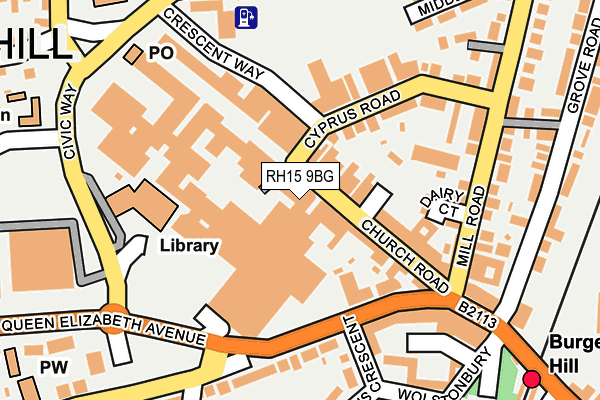
RH15 9BG is located in the Burgess Hill Meeds & Hammonds electoral ward, within the local authority district of Mid Sussex and the English Parliamentary constituency of Mid Sussex. The Sub Integrated Care Board (ICB) Location is NHS Sussex ICB - 70F and the police force is Sussex. This postcode has been in use since January 2016.


GetTheData
Source: OS OpenMap – Local (Ordnance Survey)
Source: OS VectorMap District (Ordnance Survey)
Licence: Open Government Licence (requires attribution)
| Easting | 531395 |
| Northing | 118992 |
| Latitude | 50.955387 |
| Longitude | -0.130618 |
GetTheData
Source: Open Postcode Geo
Licence: Open Government Licence
| Country | England |
| Postcode District | RH15 |
| ➜ RH15 open data dashboard ➜ See where RH15 is on a map ➜ Where is Burgess Hill? | |
GetTheData
Source: Land Registry Price Paid Data
Licence: Open Government Licence
Elevation or altitude of RH15 9BG as distance above sea level:
| Metres | Feet | |
|---|---|---|
| Elevation | 50m | 164ft |
Elevation is measured from the approximate centre of the postcode, to the nearest point on an OS contour line from OS Terrain 50, which has contour spacing of ten vertical metres.
➜ How high above sea level am I? Find the elevation of your current position using your device's GPS.
GetTheData
Source: Open Postcode Elevation
Licence: Open Government Licence
| Ward | Burgess Hill Meeds & Hammonds |
| Constituency | Mid Sussex |
GetTheData
Source: ONS Postcode Database
Licence: Open Government Licence
| January 2024 | Public order | On or near Church Road | 39m |
| January 2024 | Anti-social behaviour | On or near Church Road | 39m |
| January 2024 | Other theft | On or near Church Road | 39m |
| ➜ Get more crime data in our Crime section | |||
GetTheData
Source: data.police.uk
Licence: Open Government Licence
| Church Road | Burgess Hill | 20m |
| Church Road | Burgess Hill | 30m |
| Church Road | Burgess Hill | 32m |
| Queens Crescent (Station Road) | Burgess Hill | 124m |
| Civic Way | Burgess Hill | 199m |
| Burgess Hill Station | 0.3km |
| Wivelsfield Station | 1.2km |
| Hassocks Station | 3.6km |
GetTheData
Source: NaPTAN
Licence: Open Government Licence
GetTheData
Source: ONS Postcode Database
Licence: Open Government Licence


➜ Get more ratings from the Food Standards Agency
GetTheData
Source: Food Standards Agency
Licence: FSA terms & conditions
| Last Collection | |||
|---|---|---|---|
| Location | Mon-Fri | Sat | Distance |
| Church Road | 17:30 | 11:45 | 41m |
| Cyprus Road | 18:30 | 12:00 | 59m |
| Station Road | 18:30 | 11:45 | 108m |
GetTheData
Source: Dracos
Licence: Creative Commons Attribution-ShareAlike
| Facility | Distance |
|---|---|
| Heights Health And Fitness (Closed) The Martlets, Burgess Hill Health and Fitness Gym, Studio | 118m |
| Heights Health And Fitness Club (Closed) The Martlets, Burgess Hill Health and Fitness Gym, Studio | 118m |
| The Burgess Hill Academy Station Road, Burgess Hill Health and Fitness Gym, Grass Pitches, Sports Hall, Artificial Grass Pitch | 414m |
GetTheData
Source: Active Places
Licence: Open Government Licence
| School | Phase of Education | Distance |
|---|---|---|
| The Burgess Hill Academy Station Road, Burgess Hill, RH15 9EA | Secondary | 414m |
| St Wilfrid's Catholic Primary School, Burgess Hill School Close, Queen Elizabeth Avenue, Burgess Hill, RH15 9RJ | Primary | 446m |
| Woodlands Meed Chanctonbury Road, Burgess Hill, RH15 9EY | Not applicable | 548m |
GetTheData
Source: Edubase
Licence: Open Government Licence
The below table lists the International Territorial Level (ITL) codes (formerly Nomenclature of Territorial Units for Statistics (NUTS) codes) and Local Administrative Units (LAU) codes for RH15 9BG:
| ITL 1 Code | Name |
|---|---|
| TLJ | South East (England) |
| ITL 2 Code | Name |
| TLJ2 | Surrey, East and West Sussex |
| ITL 3 Code | Name |
| TLJ28 | West Sussex (North East) |
| LAU 1 Code | Name |
| E07000228 | Mid Sussex |
GetTheData
Source: ONS Postcode Directory
Licence: Open Government Licence
The below table lists the Census Output Area (OA), Lower Layer Super Output Area (LSOA), and Middle Layer Super Output Area (MSOA) for RH15 9BG:
| Code | Name | |
|---|---|---|
| OA | E00161697 | |
| LSOA | E01031708 | Mid Sussex 014C |
| MSOA | E02006617 | Mid Sussex 014 |
GetTheData
Source: ONS Postcode Directory
Licence: Open Government Licence
| RH15 9BP | Church Walk Mews | 47m |
| RH15 9BB | Church Road | 50m |
| RH15 9AE | Church Road | 83m |
| RH15 9BL | Church Walk | 86m |
| RH15 8FZ | Dairy Court | 126m |
| RH15 8DX | Cyprus Road | 129m |
| RH15 9BQ | Church Walk | 132m |
| RH15 9AS | Church Walk | 136m |
| RH15 9DR | Queens Crescent | 160m |
| RH15 8DR | Mill Road | 165m |
GetTheData
Source: Open Postcode Geo; Land Registry Price Paid Data
Licence: Open Government Licence