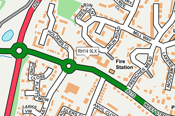
RH14 9LX lies on Arun Road in Billingshurst. RH14 9LX is located in the Billingshurst electoral ward, within the local authority district of Horsham and the English Parliamentary constituency of Horsham. The Sub Integrated Care Board (ICB) Location is NHS Sussex ICB - 70F and the police force is Sussex. This postcode has been in use since January 1980.


GetTheData
Source: OS OpenMap – Local (Ordnance Survey)
Source: OS VectorMap District (Ordnance Survey)
Licence: Open Government Licence (requires attribution)
| Easting | 508281 |
| Northing | 125935 |
| Latitude | 51.022600 |
| Longitude | -0.457499 |
GetTheData
Source: Open Postcode Geo
Licence: Open Government Licence
| Street | Arun Road |
| Town/City | Billingshurst |
| Country | England |
| Postcode District | RH14 |
| ➜ RH14 open data dashboard ➜ See where RH14 is on a map ➜ Where is Billingshurst? | |
GetTheData
Source: Land Registry Price Paid Data
Licence: Open Government Licence
Elevation or altitude of RH14 9LX as distance above sea level:
| Metres | Feet | |
|---|---|---|
| Elevation | 30m | 98ft |
Elevation is measured from the approximate centre of the postcode, to the nearest point on an OS contour line from OS Terrain 50, which has contour spacing of ten vertical metres.
➜ How high above sea level am I? Find the elevation of your current position using your device's GPS.
GetTheData
Source: Open Postcode Elevation
Licence: Open Government Licence
| Ward | Billingshurst |
| Constituency | Horsham |
GetTheData
Source: ONS Postcode Database
Licence: Open Government Licence
LONGFIELDS BUNGALOW, ARUN ROAD, BILLINGSHURST, RH14 9LX 2004 13 SEP £135,000 |
GetTheData
Source: HM Land Registry Price Paid Data
Licence: Contains HM Land Registry data © Crown copyright and database right 2024. This data is licensed under the Open Government Licence v3.0.
| November 2023 | Other theft | On or near Coombe Hill | 459m |
| November 2023 | Anti-social behaviour | On or near Coombe Hill | 459m |
| October 2023 | Anti-social behaviour | On or near Coombe Hill | 459m |
| ➜ Arun Road crime map and outcomes | |||
GetTheData
Source: data.police.uk
Licence: Open Government Licence
| Anvil Close (Forge Way) | Billingshurst | 140m |
| Anvil Close (Forge Way) | Billingshurst | 156m |
| Fire Station (West Street) | Billingshurst | 157m |
| Fire Station (West Street) | Billingshurst | 196m |
| Forge Way | Billingshurst | 330m |
| Billingshurst Station | 1km |
GetTheData
Source: NaPTAN
Licence: Open Government Licence
GetTheData
Source: ONS Postcode Database
Licence: Open Government Licence


➜ Get more ratings from the Food Standards Agency
GetTheData
Source: Food Standards Agency
Licence: FSA terms & conditions
| Last Collection | |||
|---|---|---|---|
| Location | Mon-Fri | Sat | Distance |
| Mill Lane | 17:15 | 09:30 | 177m |
| Billingshurst Delivery Office | 18:00 | 12:30 | 396m |
| Forge Way | 17:00 | 09:30 | 458m |
GetTheData
Source: Dracos
Licence: Creative Commons Attribution-ShareAlike
| Facility | Distance |
|---|---|
| Forge Way Playing Field (Closed) Forge Way, Billingshurst Grass Pitches | 191m |
| Billingshurst Jubilee Fields Newbridge Road, Billingshurst Grass Pitches | 410m |
| Luxford Way Sports Ground Luxford Way, Luxford Way, Billingshurst Grass Pitches | 642m |
GetTheData
Source: Active Places
Licence: Open Government Licence
| School | Phase of Education | Distance |
|---|---|---|
| Billingshurst Primary School Upper Station Road, Billingshurst, RH14 9RE | Primary | 526m |
| Billingshurst Primary School Upper Station Road, Billingshurst, RH14 9RE | Primary | 616m |
| Weald School, The Station Road, Billingshurst, RH14 9RY | Secondary | 688m |
GetTheData
Source: Edubase
Licence: Open Government Licence
The below table lists the International Territorial Level (ITL) codes (formerly Nomenclature of Territorial Units for Statistics (NUTS) codes) and Local Administrative Units (LAU) codes for RH14 9LX:
| ITL 1 Code | Name |
|---|---|
| TLJ | South East (England) |
| ITL 2 Code | Name |
| TLJ2 | Surrey, East and West Sussex |
| ITL 3 Code | Name |
| TLJ28 | West Sussex (North East) |
| LAU 1 Code | Name |
| E07000227 | Horsham |
GetTheData
Source: ONS Postcode Directory
Licence: Open Government Licence
The below table lists the Census Output Area (OA), Lower Layer Super Output Area (LSOA), and Middle Layer Super Output Area (MSOA) for RH14 9LX:
| Code | Name | |
|---|---|---|
| OA | E00167718 | |
| LSOA | E01031614 | Horsham 010D |
| MSOA | E02006597 | Horsham 010 |
GetTheData
Source: ONS Postcode Directory
Licence: Open Government Licence
| RH14 9NR | West Street | 19m |
| RH14 9PE | Arun Road | 93m |
| RH14 9LJ | Forge Way | 132m |
| RH14 9LE | Frenches Mead | 145m |
| RH14 9NB | Arun Road | 156m |
| RH14 9HL | Holders Close | 161m |
| RH14 9NQ | Anvil Close | 183m |
| RH14 9LD | Mill Way | 183m |
| RH14 9LH | West Street | 193m |
| RH14 9GL | Saddlers Close | 202m |
GetTheData
Source: Open Postcode Geo; Land Registry Price Paid Data
Licence: Open Government Licence