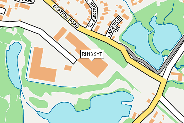
RH13 9YT is located in the Southwater South & Shipley electoral ward, within the local authority district of Horsham and the English Parliamentary constituency of Horsham. The Sub Integrated Care Board (ICB) Location is NHS Sussex ICB - 70F and the police force is Sussex. This postcode has been in use since June 2002.


GetTheData
Source: OS OpenMap – Local (Ordnance Survey)
Source: OS VectorMap District (Ordnance Survey)
Licence: Open Government Licence (requires attribution)
| Easting | 515953 |
| Northing | 125993 |
| Latitude | 51.021622 |
| Longitude | -0.348113 |
GetTheData
Source: Open Postcode Geo
Licence: Open Government Licence
| Country | England |
| Postcode District | RH13 |
| ➜ RH13 open data dashboard ➜ See where RH13 is on a map ➜ Where is Southwater? | |
GetTheData
Source: Land Registry Price Paid Data
Licence: Open Government Licence
Elevation or altitude of RH13 9YT as distance above sea level:
| Metres | Feet | |
|---|---|---|
| Elevation | 40m | 131ft |
Elevation is measured from the approximate centre of the postcode, to the nearest point on an OS contour line from OS Terrain 50, which has contour spacing of ten vertical metres.
➜ How high above sea level am I? Find the elevation of your current position using your device's GPS.
GetTheData
Source: Open Postcode Elevation
Licence: Open Government Licence
| Ward | Southwater South & Shipley |
| Constituency | Horsham |
GetTheData
Source: ONS Postcode Database
Licence: Open Government Licence
| June 2022 | Violence and sexual offences | On or near Little Bridges Close | 193m |
| June 2022 | Burglary | On or near Park/Open Space | 218m |
| June 2022 | Violence and sexual offences | On or near Bakers Close | 347m |
| ➜ Get more crime data in our Crime section | |||
GetTheData
Source: data.police.uk
Licence: Open Government Licence
| Country Park (Cripplegate Lane) | Southwater | 249m |
| York Close (Cedar Drive) | Southwater | 350m |
| College Road (Worthing Road) | Southwater | 361m |
| Cock Inn (Worthing Road) | Southwater | 364m |
| York Close (Cedar Drive) | Southwater | 377m |
| Christs Hospital Station | 3.4km |
| Horsham Station | 5.3km |
GetTheData
Source: NaPTAN
Licence: Open Government Licence
GetTheData
Source: ONS Postcode Database
Licence: Open Government Licence


➜ Get more ratings from the Food Standards Agency
GetTheData
Source: Food Standards Agency
Licence: FSA terms & conditions
| Last Collection | |||
|---|---|---|---|
| Location | Mon-Fri | Sat | Distance |
| Cedar Drive | 16:15 | 07:30 | 440m |
| Charlock Way | 17:00 | 08:00 | 1,306m |
| Robin Hood | 17:00 | 09:30 | 1,958m |
GetTheData
Source: Dracos
Licence: Creative Commons Attribution-ShareAlike
| Facility | Distance |
|---|---|
| The Ghyll Pevensey Road, Southwater, Horsham Sports Hall, Health and Fitness Gym, Grass Pitches, Studio | 458m |
| Southwater Cricket Club Church Lane, Southwater, Horsham Grass Pitches | 641m |
| Southwater Junior Academy Worthing Road, Southwater, Horsham Grass Pitches, Sports Hall | 840m |
GetTheData
Source: Active Places
Licence: Open Government Licence
| School | Phase of Education | Distance |
|---|---|---|
| Southwater Infant Academy Worthing Road, Southwater, Horsham, RH13 9JH | Primary | 706m |
| Southwater Junior Academy Worthing Road, Southwater, Horsham, RH13 9JH | Primary | 847m |
| Castlewood Primary School Castlewood Road, Southwater, Horsham, RH13 9US | Primary | 1km |
GetTheData
Source: Edubase
Licence: Open Government Licence
The below table lists the International Territorial Level (ITL) codes (formerly Nomenclature of Territorial Units for Statistics (NUTS) codes) and Local Administrative Units (LAU) codes for RH13 9YT:
| ITL 1 Code | Name |
|---|---|
| TLJ | South East (England) |
| ITL 2 Code | Name |
| TLJ2 | Surrey, East and West Sussex |
| ITL 3 Code | Name |
| TLJ28 | West Sussex (North East) |
| LAU 1 Code | Name |
| E07000227 | Horsham |
GetTheData
Source: ONS Postcode Directory
Licence: Open Government Licence
The below table lists the Census Output Area (OA), Lower Layer Super Output Area (LSOA), and Middle Layer Super Output Area (MSOA) for RH13 9YT:
| Code | Name | |
|---|---|---|
| OA | E00161563 | |
| LSOA | E01031678 | Horsham 009B |
| MSOA | E02006596 | Horsham 009 |
GetTheData
Source: ONS Postcode Directory
Licence: Open Government Licence
| RH13 9TR | Lakeside Drive | 158m |
| RH13 9HH | Little Bridges Close | 186m |
| RH13 9JP | Peters Close | 268m |
| RH13 9HJ | Cripplegate Lane | 273m |
| RH13 9HQ | Station Road | 278m |
| RH13 9XJ | York Close | 312m |
| RH13 9DX | Bakers Close | 317m |
| RH13 9LH | Fairbank Road | 317m |
| RH13 9DY | Andrews Lane | 325m |
| RH13 9HN | Cripplegate Lane | 325m |
GetTheData
Source: Open Postcode Geo; Land Registry Price Paid Data
Licence: Open Government Licence