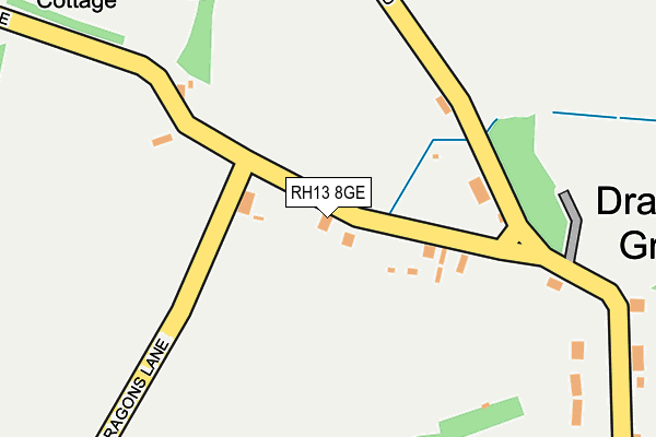
RH13 8GE lies on Dragons Lane in Shipley, Horsham. RH13 8GE is located in the Southwater South & Shipley electoral ward, within the local authority district of Horsham and the English Parliamentary constituency of Horsham. The Sub Integrated Care Board (ICB) Location is NHS Sussex ICB - 70F and the police force is Sussex. This postcode has been in use since June 2002.


GetTheData
Source: OS OpenMap – Local (Ordnance Survey)
Source: OS VectorMap District (Ordnance Survey)
Licence: Open Government Licence (requires attribution)
| Easting | 514027 |
| Northing | 123460 |
| Latitude | 50.999244 |
| Longitude | -0.376383 |
GetTheData
Source: Open Postcode Geo
Licence: Open Government Licence
| Street | Dragons Lane |
| Locality | Shipley |
| Town/City | Horsham |
| Country | England |
| Postcode District | RH13 |
| ➜ RH13 open data dashboard ➜ See where RH13 is on a map ➜ Where is Dragon's Green? | |
GetTheData
Source: Land Registry Price Paid Data
Licence: Open Government Licence
Elevation or altitude of RH13 8GE as distance above sea level:
| Metres | Feet | |
|---|---|---|
| Elevation | 30m | 98ft |
Elevation is measured from the approximate centre of the postcode, to the nearest point on an OS contour line from OS Terrain 50, which has contour spacing of ten vertical metres.
➜ How high above sea level am I? Find the elevation of your current position using your device's GPS.
GetTheData
Source: Open Postcode Elevation
Licence: Open Government Licence
| Ward | Southwater South & Shipley |
| Constituency | Horsham |
GetTheData
Source: ONS Postcode Database
Licence: Open Government Licence
| June 2022 | Vehicle crime | On or near Dragons Lane | 86m |
| April 2022 | Public order | On or near Dragons Lane | 86m |
| March 2022 | Burglary | On or near Dragons Lane | 86m |
| ➜ Get more crime data in our Crime section | |||
GetTheData
Source: data.police.uk
Licence: Open Government Licence
| Primary School (School Lane) | Shipley | 1,292m |
| Red Lane | Shipley | 1,429m |
| Red Lane | Shipley | 1,439m |
| North Lodge (A272) | Shipley | 1,467m |
| North Lodge (A272) | Shipley | 1,471m |
GetTheData
Source: NaPTAN
Licence: Open Government Licence
| Percentage of properties with Next Generation Access | 100.0% |
| Percentage of properties with Superfast Broadband | 100.0% |
| Percentage of properties with Ultrafast Broadband | 0.0% |
| Percentage of properties with Full Fibre Broadband | 0.0% |
Superfast Broadband is between 30Mbps and 300Mbps
Ultrafast Broadband is > 300Mbps
| Percentage of properties unable to receive 2Mbps | 0.0% |
| Percentage of properties unable to receive 5Mbps | 0.0% |
| Percentage of properties unable to receive 10Mbps | 0.0% |
| Percentage of properties unable to receive 30Mbps | 0.0% |
GetTheData
Source: Ofcom
Licence: Ofcom Terms of Use (requires attribution)
GetTheData
Source: ONS Postcode Database
Licence: Open Government Licence


➜ Get more ratings from the Food Standards Agency
GetTheData
Source: Food Standards Agency
Licence: FSA terms & conditions
| Last Collection | |||
|---|---|---|---|
| Location | Mon-Fri | Sat | Distance |
| Broomers Corner | 16:15 | 08:30 | 2,774m |
| Cross Lane | 16:30 | 09:30 | 2,868m |
| Cedar Drive | 16:15 | 07:30 | 3,617m |
GetTheData
Source: Dracos
Licence: Creative Commons Attribution-ShareAlike
| Facility | Distance |
|---|---|
| Dragons Green Playing Field Dragons Lane, Shipley, Horsham Grass Pitches | 569m |
| William Penn School Brooks Green Road, Coolham, Horsham Grass Pitches | 2km |
| Knepp Castle Polo Club Knepp Castle, West Grinstead Grass Pitches | 2.4km |
GetTheData
Source: Active Places
Licence: Open Government Licence
| School | Phase of Education | Distance |
|---|---|---|
| Shipley CofE Primary School School Lane, Shipley, Horsham, RH13 8PL | Primary | 1.4km |
| William Penn School Brooks Green Road, Coolham, Horsham, RH13 8GR | Primary | 2km |
| Southwater Infant Academy Worthing Road, Southwater, Horsham, RH13 9JH | Primary | 3.6km |
GetTheData
Source: Edubase
Licence: Open Government Licence
The below table lists the International Territorial Level (ITL) codes (formerly Nomenclature of Territorial Units for Statistics (NUTS) codes) and Local Administrative Units (LAU) codes for RH13 8GE:
| ITL 1 Code | Name |
|---|---|
| TLJ | South East (England) |
| ITL 2 Code | Name |
| TLJ2 | Surrey, East and West Sussex |
| ITL 3 Code | Name |
| TLJ28 | West Sussex (North East) |
| LAU 1 Code | Name |
| E07000227 | Horsham |
GetTheData
Source: ONS Postcode Directory
Licence: Open Government Licence
The below table lists the Census Output Area (OA), Lower Layer Super Output Area (LSOA), and Middle Layer Super Output Area (MSOA) for RH13 8GE:
| Code | Name | |
|---|---|---|
| OA | E00161227 | |
| LSOA | E01031611 | Horsham 010A |
| MSOA | E02006597 | Horsham 010 |
GetTheData
Source: ONS Postcode Directory
Licence: Open Government Licence
| RH13 8GF | Bakers Lane | 328m |
| RH13 8GD | Dragons Lane | 364m |
| RH13 8PB | Green Street | 693m |
| RH13 8PE | Smithers Hill Lane | 850m |
| RH13 8PF | Coolham Road | 927m |
| RH13 8PQ | Green Street | 962m |
| RH13 8PA | Coolham Road | 1168m |
| RH13 8GL | Bakers Lane | 1232m |
| RH13 8PL | School Lane | 1432m |
| RH13 8PG | Pound Lane | 1511m |
GetTheData
Source: Open Postcode Geo; Land Registry Price Paid Data
Licence: Open Government Licence