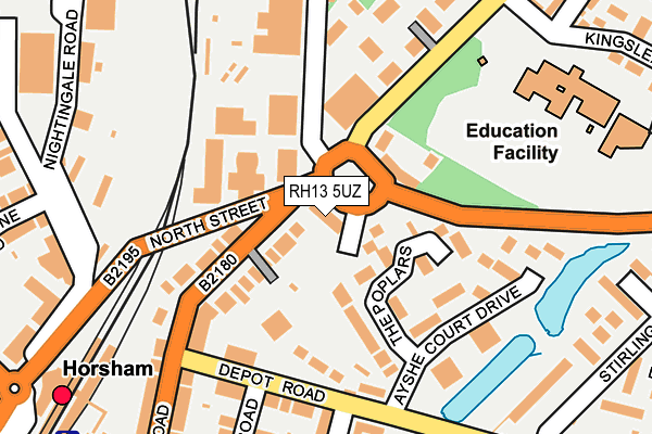
RH13 5UZ is located in the Forest electoral ward, within the local authority district of Horsham and the English Parliamentary constituency of Horsham. The Sub Integrated Care Board (ICB) Location is NHS Sussex ICB - 70F and the police force is Sussex. This postcode has been in use since October 2019.


GetTheData
Source: OS OpenMap – Local (Ordnance Survey)
Source: OS VectorMap District (Ordnance Survey)
Licence: Open Government Licence (requires attribution)
| Easting | 518119 |
| Northing | 131142 |
| Latitude | 51.067463 |
| Longitude | -0.315567 |
GetTheData
Source: Open Postcode Geo
Licence: Open Government Licence
| Country | England |
| Postcode District | RH13 |
| ➜ RH13 open data dashboard ➜ See where RH13 is on a map ➜ Where is Horsham? | |
GetTheData
Source: Land Registry Price Paid Data
Licence: Open Government Licence
Elevation or altitude of RH13 5UZ as distance above sea level:
| Metres | Feet | |
|---|---|---|
| Elevation | 60m | 197ft |
Elevation is measured from the approximate centre of the postcode, to the nearest point on an OS contour line from OS Terrain 50, which has contour spacing of ten vertical metres.
➜ How high above sea level am I? Find the elevation of your current position using your device's GPS.
GetTheData
Source: Open Postcode Elevation
Licence: Open Government Licence
| Ward | Forest |
| Constituency | Horsham |
GetTheData
Source: ONS Postcode Database
Licence: Open Government Licence
| January 2024 | Anti-social behaviour | On or near Parking Area | 408m |
| January 2024 | Violence and sexual offences | On or near Parking Area | 408m |
| January 2024 | Anti-social behaviour | On or near Parking Area | 408m |
| ➜ Get more crime data in our Crime section | |||
GetTheData
Source: data.police.uk
Licence: Open Government Licence
| Kingslea Primary School (Kings Road) | Horsham | 105m |
| Kingslea Primary School (Kings Road) | Horsham | 144m |
| Depot Road (Station Road) | Oakhill | 154m |
| Ayshe Court Drive (Depot Road) | Oakhill | 162m |
| Ayshe Court Drive (Depot Road) | Oakhill | 199m |
| Horsham Station | 0.3km |
| Littlehaven Station | 1.5km |
| Warnham Station | 3km |
GetTheData
Source: NaPTAN
Licence: Open Government Licence
GetTheData
Source: ONS Postcode Database
Licence: Open Government Licence


➜ Get more ratings from the Food Standards Agency
GetTheData
Source: Food Standards Agency
Licence: FSA terms & conditions
| Last Collection | |||
|---|---|---|---|
| Location | Mon-Fri | Sat | Distance |
| Depot Road | 17:00 | 12:00 | 217m |
| Station Road P O | 16:30 | 12:00 | 282m |
| Horsham Delivery Office | 18:30 | 12:45 | 411m |
GetTheData
Source: Dracos
Licence: Creative Commons Attribution-ShareAlike
| Facility | Distance |
|---|---|
| Kingslea Primary School Kingslea, Horsham Grass Pitches | 249m |
| Curves For Women (Horsham) (Closed) Gladstone Road, Horsham Health and Fitness Gym | 344m |
| Pavilions In The Park Hurst Road, Horsham Swimming Pool, Health and Fitness Gym, Sports Hall, Studio | 556m |
GetTheData
Source: Active Places
Licence: Open Government Licence
| School | Phase of Education | Distance |
|---|---|---|
| Horsham Nursery School Harwood Road, Horsham, RH13 5UT | Nursery | 284m |
| Kingslea Primary School Kings Road, Horsham, RH13 5PS | Primary | 352m |
| Millais School Depot Road, Horsham, RH13 5HR | Secondary | 710m |
GetTheData
Source: Edubase
Licence: Open Government Licence
The below table lists the International Territorial Level (ITL) codes (formerly Nomenclature of Territorial Units for Statistics (NUTS) codes) and Local Administrative Units (LAU) codes for RH13 5UZ:
| ITL 1 Code | Name |
|---|---|
| TLJ | South East (England) |
| ITL 2 Code | Name |
| TLJ2 | Surrey, East and West Sussex |
| ITL 3 Code | Name |
| TLJ28 | West Sussex (North East) |
| LAU 1 Code | Name |
| E07000227 | Horsham |
GetTheData
Source: ONS Postcode Directory
Licence: Open Government Licence
The below table lists the Census Output Area (OA), Lower Layer Super Output Area (LSOA), and Middle Layer Super Output Area (MSOA) for RH13 5UZ:
| Code | Name | |
|---|---|---|
| OA | E00161416 | |
| LSOA | E01031654 | Horsham 004A |
| MSOA | E02006591 | Horsham 004 |
GetTheData
Source: ONS Postcode Directory
Licence: Open Government Licence
| RH13 5UR | Kings Court | 76m |
| RH13 5EU | Station Road | 99m |
| RH13 5RH | The Poplars | 102m |
| RH13 5EX | Station Road | 112m |
| RH13 5HB | Depot Road | 128m |
| RH13 5RJ | Ayshe Court Drive | 165m |
| RH13 5RW | Chequers Court | 171m |
| RH13 5HA | Depot Road | 174m |
| RH13 5RL | Ayshe Court Drive | 184m |
| RH13 5RN | Ayshe Court Drive | 186m |
GetTheData
Source: Open Postcode Geo; Land Registry Price Paid Data
Licence: Open Government Licence