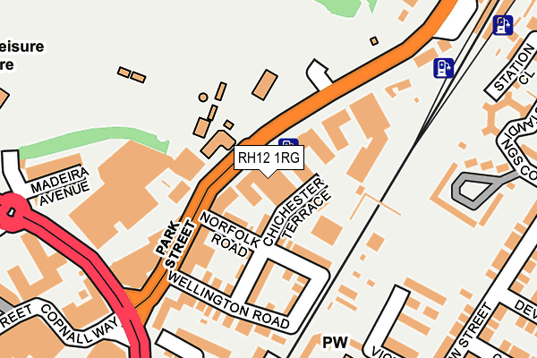
RH12 1RG is located in the Denne electoral ward, within the local authority district of Horsham and the English Parliamentary constituency of Horsham. The Sub Integrated Care Board (ICB) Location is NHS Sussex ICB - 70F and the police force is Sussex. This postcode has been in use since January 1980.


GetTheData
Source: OS OpenMap – Local (Ordnance Survey)
Source: OS VectorMap District (Ordnance Survey)
Licence: Open Government Licence (requires attribution)
| Easting | 517622 |
| Northing | 130759 |
| Latitude | 51.064123 |
| Longitude | -0.322781 |
GetTheData
Source: Open Postcode Geo
Licence: Open Government Licence
| Country | England |
| Postcode District | RH12 |
| ➜ RH12 open data dashboard ➜ See where RH12 is on a map ➜ Where is Horsham? | |
GetTheData
Source: Land Registry Price Paid Data
Licence: Open Government Licence
Elevation or altitude of RH12 1RG as distance above sea level:
| Metres | Feet | |
|---|---|---|
| Elevation | 50m | 164ft |
Elevation is measured from the approximate centre of the postcode, to the nearest point on an OS contour line from OS Terrain 50, which has contour spacing of ten vertical metres.
➜ How high above sea level am I? Find the elevation of your current position using your device's GPS.
GetTheData
Source: Open Postcode Elevation
Licence: Open Government Licence
| Ward | Denne |
| Constituency | Horsham |
GetTheData
Source: ONS Postcode Database
Licence: Open Government Licence
| January 2024 | Anti-social behaviour | On or near Parking Area | 235m |
| January 2024 | Anti-social behaviour | On or near Parking Area | 235m |
| January 2024 | Violence and sexual offences | On or near Parking Area | 235m |
| ➜ Get more crime data in our Crime section | |||
GetTheData
Source: data.police.uk
Licence: Open Government Licence
| Railway Station (North Street) | Horsham | 235m |
| Railway Station (North Street) | Horsham | 271m |
| Park Way | Horsham | 325m |
| Denne Road (East Street) | Horsham | 355m |
| The Bedford Ph (Station Road) | Oakhill | 364m |
| Horsham Station | 0.3km |
| Littlehaven Station | 2km |
| Christs Hospital Station | 3.2km |
GetTheData
Source: NaPTAN
Licence: Open Government Licence
GetTheData
Source: ONS Postcode Database
Licence: Open Government Licence


➜ Get more ratings from the Food Standards Agency
GetTheData
Source: Food Standards Agency
Licence: FSA terms & conditions
| Last Collection | |||
|---|---|---|---|
| Location | Mon-Fri | Sat | Distance |
| New Street | 17:00 | 12:00 | 294m |
| Carfax P O | 18:30 | 12:30 | 364m |
| Station Road P O | 16:30 | 12:00 | 376m |
GetTheData
Source: Dracos
Licence: Creative Commons Attribution-ShareAlike
| Facility | Distance |
|---|---|
| Pavilions In The Park Hurst Road, Horsham Swimming Pool, Health and Fitness Gym, Sports Hall, Studio | 263m |
| Curves For Women (Horsham) (Closed) Gladstone Road, Horsham Health and Fitness Gym | 397m |
| Horsham Park Horsham Grass Pitches, Outdoor Tennis Courts | 489m |
GetTheData
Source: Active Places
Licence: Open Government Licence
| School | Phase of Education | Distance |
|---|---|---|
| St Mary's CofE (Aided) Primary School Normandy, Horsham, RH12 1JL | Primary | 745m |
| The College of Richard Collyer In Horsham Hurst Road, Horsham, RH12 2EJ | 16 plus | 812m |
| Horsham Nursery School Harwood Road, Horsham, RH13 5UT | Nursery | 898m |
GetTheData
Source: Edubase
Licence: Open Government Licence
The below table lists the International Territorial Level (ITL) codes (formerly Nomenclature of Territorial Units for Statistics (NUTS) codes) and Local Administrative Units (LAU) codes for RH12 1RG:
| ITL 1 Code | Name |
|---|---|
| TLJ | South East (England) |
| ITL 2 Code | Name |
| TLJ2 | Surrey, East and West Sussex |
| ITL 3 Code | Name |
| TLJ28 | West Sussex (North East) |
| LAU 1 Code | Name |
| E07000227 | Horsham |
GetTheData
Source: ONS Postcode Directory
Licence: Open Government Licence
The below table lists the Census Output Area (OA), Lower Layer Super Output Area (LSOA), and Middle Layer Super Output Area (MSOA) for RH12 1RG:
| Code | Name | |
|---|---|---|
| OA | E00161421 | |
| LSOA | E01031656 | Horsham 006D |
| MSOA | E02006593 | Horsham 006 |
GetTheData
Source: ONS Postcode Directory
Licence: Open Government Licence
| RH12 1DJ | Chichester Terrace | 56m |
| RH12 1BZ | Norfolk Road | 70m |
| RH12 1RJ | North Street | 72m |
| RH12 1DB | Chichester Terrace | 90m |
| RH12 1DA | Norfolk Terrace | 136m |
| RH12 1DD | Wellington Road | 156m |
| RH12 1BX | Park Street | 170m |
| RH13 5DQ | Trinity Square | 215m |
| RH12 1RD | North Street | 222m |
| RH12 1HY | Park Terrace West | 228m |
GetTheData
Source: Open Postcode Geo; Land Registry Price Paid Data
Licence: Open Government Licence