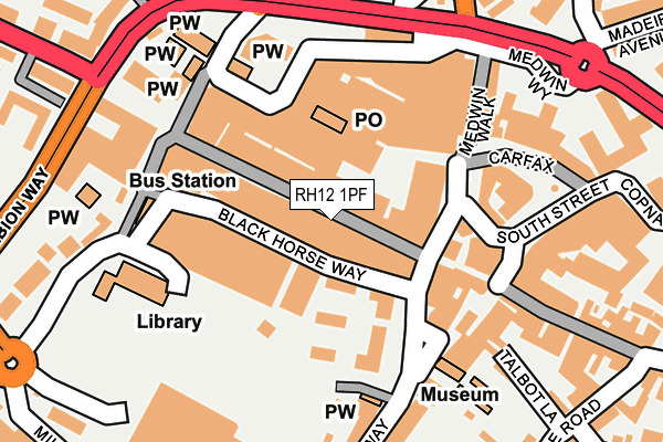
RH12 1PF is located in the Denne electoral ward, within the local authority district of Horsham and the English Parliamentary constituency of Horsham. The Sub Integrated Care Board (ICB) Location is NHS Sussex ICB - 70F and the police force is Sussex. This postcode has been in use since January 1980.


GetTheData
Source: OS OpenMap – Local (Ordnance Survey)
Source: OS VectorMap District (Ordnance Survey)
Licence: Open Government Licence (requires attribution)
| Easting | 517104 |
| Northing | 130579 |
| Latitude | 51.062610 |
| Longitude | -0.330228 |
GetTheData
Source: Open Postcode Geo
Licence: Open Government Licence
| Country | England |
| Postcode District | RH12 |
| ➜ RH12 open data dashboard ➜ See where RH12 is on a map ➜ Where is Horsham? | |
GetTheData
Source: Land Registry Price Paid Data
Licence: Open Government Licence
Elevation or altitude of RH12 1PF as distance above sea level:
| Metres | Feet | |
|---|---|---|
| Elevation | 40m | 131ft |
Elevation is measured from the approximate centre of the postcode, to the nearest point on an OS contour line from OS Terrain 50, which has contour spacing of ten vertical metres.
➜ How high above sea level am I? Find the elevation of your current position using your device's GPS.
GetTheData
Source: Open Postcode Elevation
Licence: Open Government Licence
| Ward | Denne |
| Constituency | Horsham |
GetTheData
Source: ONS Postcode Database
Licence: Open Government Licence
| January 2024 | Drugs | On or near Parking Area | 86m |
| January 2024 | Public order | On or near Parking Area | 86m |
| January 2024 | Public order | On or near Parking Area | 86m |
| ➜ Get more crime data in our Crime section | |||
GetTheData
Source: data.police.uk
Licence: Open Government Licence
| Bus Station (Bus Terminus) | Horsham | 172m |
| Bus Station (Bus Terminus) | Horsham | 174m |
| Bus Station (Bus Terminus) | Horsham | 176m |
| Bus Station (Bus Terminus) | Horsham | 177m |
| Carfax (South Street) | Horsham | 178m |
| Horsham Station | 0.9km |
| Littlehaven Station | 2.5km |
| Christs Hospital Station | 2.7km |
GetTheData
Source: NaPTAN
Licence: Open Government Licence
GetTheData
Source: ONS Postcode Database
Licence: Open Government Licence


➜ Get more ratings from the Food Standards Agency
GetTheData
Source: Food Standards Agency
Licence: FSA terms & conditions
| Last Collection | |||
|---|---|---|---|
| Location | Mon-Fri | Sat | Distance |
| Market Square | 18:30 | 12:00 | 154m |
| Bishopric | 18:30 | 11:15 | 165m |
| Carfax P O | 18:30 | 12:30 | 185m |
GetTheData
Source: Dracos
Licence: Creative Commons Attribution-ShareAlike
| Facility | Distance |
|---|---|
| The Gym Group (Horsham) Albion Way, Horsham Health and Fitness Gym | 242m |
| Horsham Park Horsham Grass Pitches, Outdoor Tennis Courts | 511m |
| Horsham Sports Club Cricketfield Road, Horsham Grass Pitches, Squash Courts, Outdoor Tennis Courts, Health and Fitness Gym | 545m |
GetTheData
Source: Active Places
Licence: Open Government Licence
| School | Phase of Education | Distance |
|---|---|---|
| St Mary's CofE (Aided) Primary School Normandy, Horsham, RH12 1JL | Primary | 372m |
| St John's Catholic Primary School Blackbridge Lane, Horsham, RH12 1RR | Primary | 818m |
| Arunside School, Horsham Blackbridge Lane, Horsham, RH12 1RR | Primary | 818m |
GetTheData
Source: Edubase
Licence: Open Government Licence
The below table lists the International Territorial Level (ITL) codes (formerly Nomenclature of Territorial Units for Statistics (NUTS) codes) and Local Administrative Units (LAU) codes for RH12 1PF:
| ITL 1 Code | Name |
|---|---|
| TLJ | South East (England) |
| ITL 2 Code | Name |
| TLJ2 | Surrey, East and West Sussex |
| ITL 3 Code | Name |
| TLJ28 | West Sussex (North East) |
| LAU 1 Code | Name |
| E07000227 | Horsham |
GetTheData
Source: ONS Postcode Directory
Licence: Open Government Licence
The below table lists the Census Output Area (OA), Lower Layer Super Output Area (LSOA), and Middle Layer Super Output Area (MSOA) for RH12 1PF:
| Code | Name | |
|---|---|---|
| OA | E00161339 | |
| LSOA | E01031636 | Horsham 006A |
| MSOA | E02006593 | Horsham 006 |
GetTheData
Source: ONS Postcode Directory
Licence: Open Government Licence
| RH12 1PL | West Street | 19m |
| RH12 1NU | Blackhorse Way | 44m |
| RH12 1NN | Blackhorse Way | 57m |
| RH12 1PB | West Street | 61m |
| RH12 1PP | West Street | 74m |
| RH12 1NP | Blackhorse Way | 93m |
| RH12 1PS | Lower Tanbridge Way | 105m |
| RH12 1DW | Carfax | 110m |
| RH12 1NQ | Causeway | 121m |
| RH12 1EQ | Carfax | 140m |
GetTheData
Source: Open Postcode Geo; Land Registry Price Paid Data
Licence: Open Government Licence