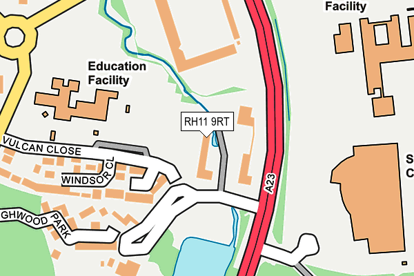
RH11 9RT lies on Broadfield Park in Pease Pottage, Crawley. RH11 9RT is located in the Broadfield electoral ward, within the local authority district of Crawley and the English Parliamentary constituency of Crawley. The Sub Integrated Care Board (ICB) Location is NHS Sussex ICB - 70F and the police force is Sussex. This postcode has been in use since July 1990.


GetTheData
Source: OS OpenMap – Local (Ordnance Survey)
Source: OS VectorMap District (Ordnance Survey)
Licence: Open Government Licence (requires attribution)
| Easting | 526504 |
| Northing | 134707 |
| Latitude | 51.097719 |
| Longitude | -0.194711 |
GetTheData
Source: Open Postcode Geo
Licence: Open Government Licence
| Street | Broadfield Park |
| Locality | Pease Pottage |
| Town/City | Crawley |
| Country | England |
| Postcode District | RH11 |
➜ See where RH11 is on a map ➜ Where is Crawley? | |
GetTheData
Source: Land Registry Price Paid Data
Licence: Open Government Licence
Elevation or altitude of RH11 9RT as distance above sea level:
| Metres | Feet | |
|---|---|---|
| Elevation | 90m | 295ft |
Elevation is measured from the approximate centre of the postcode, to the nearest point on an OS contour line from OS Terrain 50, which has contour spacing of ten vertical metres.
➜ How high above sea level am I? Find the elevation of your current position using your device's GPS.
GetTheData
Source: Open Postcode Elevation
Licence: Open Government Licence
| Ward | Broadfield |
| Constituency | Crawley |
GetTheData
Source: ONS Postcode Database
Licence: Open Government Licence
| Broadfield Park (A23) | Broadfield | 88m |
| K2 Leisure Centre | Tilgate | 182m |
| Stadium (Coachmans Drive) | Broadfield | 299m |
| Stadium (Coachmans Drive) | Broadfield | 313m |
| Tilgate Park (Brighton Road) | Broadfield | 335m |
| Crawley Station | 1.7km |
| Ifield Station | 2.4km |
| Three Bridges Station | 3.2km |
GetTheData
Source: NaPTAN
Licence: Open Government Licence
GetTheData
Source: ONS Postcode Database
Licence: Open Government Licence


➜ Get more ratings from the Food Standards Agency
GetTheData
Source: Food Standards Agency
Licence: FSA terms & conditions
| Last Collection | |||
|---|---|---|---|
| Location | Mon-Fri | Sat | Distance |
| Vulcan Close | 17:00 | 11:30 | 248m |
| Ashdown Drive | 17:30 | 11:00 | 521m |
| Winchester Road | 17:30 | 11:15 | 705m |
GetTheData
Source: Dracos
Licence: Creative Commons Attribution-ShareAlike
| Risk of RH11 9RT flooding from rivers and sea | Medium |
| ➜ RH11 9RT flood map | |
GetTheData
Source: Open Flood Risk by Postcode
Licence: Open Government Licence
The below table lists the International Territorial Level (ITL) codes (formerly Nomenclature of Territorial Units for Statistics (NUTS) codes) and Local Administrative Units (LAU) codes for RH11 9RT:
| ITL 1 Code | Name |
|---|---|
| TLJ | South East (England) |
| ITL 2 Code | Name |
| TLJ2 | Surrey, East and West Sussex |
| ITL 3 Code | Name |
| TLJ28 | West Sussex (North East) |
| LAU 1 Code | Name |
| E07000226 | Crawley |
GetTheData
Source: ONS Postcode Directory
Licence: Open Government Licence
The below table lists the Census Output Area (OA), Lower Layer Super Output Area (LSOA), and Middle Layer Super Output Area (MSOA) for RH11 9RT:
| Code | Name | |
|---|---|---|
| OA | E00160927 | |
| LSOA | E01031557 | Crawley 013C |
| MSOA | E02006587 | Crawley 013 |
GetTheData
Source: ONS Postcode Directory
Licence: Open Government Licence
| RH11 9PB | Marlborough Close | 102m |
| RH11 9PD | Vulcan Close | 167m |
| RH11 9PA | Windsor Close | 185m |
| RH11 9PP | Highwood Park | 209m |
| RH10 5PH | Tilgate Drive | 270m |
| RH11 9PE | Mountbatten Close | 278m |
| RH11 9BD | Pease Pottage Hill | 303m |
| RH11 9HG | Anglesey Close | 376m |
| RH11 9LZ | Greenwich Close | 382m |
| RH11 9NP | Regents Close | 398m |
GetTheData
Source: Open Postcode Geo; Land Registry Price Paid Data
Licence: Open Government Licence