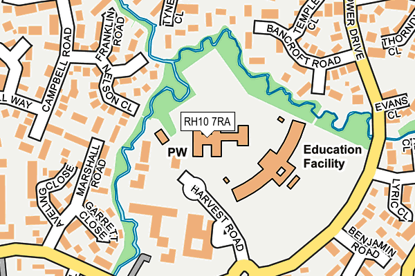
RH10 7RA is located in the Maidenbower electoral ward, within the local authority district of Crawley and the English Parliamentary constituency of Crawley. The Sub Integrated Care Board (ICB) Location is NHS Sussex ICB - 70F and the police force is Sussex. This postcode has been in use since January 1992.


GetTheData
Source: OS OpenMap – Local (Ordnance Survey)
Source: OS VectorMap District (Ordnance Survey)
Licence: Open Government Licence (requires attribution)
| Easting | 529459 |
| Northing | 135960 |
| Latitude | 51.108326 |
| Longitude | -0.152111 |
GetTheData
Source: Open Postcode Geo
Licence: Open Government Licence
| Country | England |
| Postcode District | RH10 |
| ➜ RH10 open data dashboard ➜ See where RH10 is on a map ➜ Where is Crawley? | |
GetTheData
Source: Land Registry Price Paid Data
Licence: Open Government Licence
Elevation or altitude of RH10 7RA as distance above sea level:
| Metres | Feet | |
|---|---|---|
| Elevation | 80m | 262ft |
Elevation is measured from the approximate centre of the postcode, to the nearest point on an OS contour line from OS Terrain 50, which has contour spacing of ten vertical metres.
➜ How high above sea level am I? Find the elevation of your current position using your device's GPS.
GetTheData
Source: Open Postcode Elevation
Licence: Open Government Licence
| Ward | Maidenbower |
| Constituency | Crawley |
GetTheData
Source: ONS Postcode Database
Licence: Open Government Licence
| January 2024 | Other crime | On or near Baxter Close | 494m |
| December 2023 | Violence and sexual offences | On or near Parking Area | 96m |
| December 2023 | Other theft | On or near Parking Area | 96m |
| ➜ Get more crime data in our Crime section | |||
GetTheData
Source: data.police.uk
Licence: Open Government Licence
| Village Centre (Harvest Road) | Maidenbower | 112m |
| Maidenbower Place (Maidenbower Drive) | Maidenbower | 204m |
| Delfont Close (Maidenbower Drive) | Maidenbower | 230m |
| Maidenbower Place (Maidenbower Drive) | Maidenbower | 243m |
| Evans Close (Maidenbower Drive) | Maidenbower | 257m |
| Three Bridges Station | 1.1km |
| Crawley Station | 2.5km |
| Ifield Station | 4.5km |
GetTheData
Source: NaPTAN
Licence: Open Government Licence
GetTheData
Source: ONS Postcode Database
Licence: Open Government Licence

➜ Get more ratings from the Food Standards Agency
GetTheData
Source: Food Standards Agency
Licence: FSA terms & conditions
| Last Collection | |||
|---|---|---|---|
| Location | Mon-Fri | Sat | Distance |
| Maidenbower Square P O | 17:30 | 12:15 | 124m |
| Westminster Road | 17:30 | 12:15 | 280m |
| Lucerne Drive | 17:00 | 11:45 | 402m |
GetTheData
Source: Dracos
Licence: Creative Commons Attribution-ShareAlike
| Facility | Distance |
|---|---|
| Maidenbower Junior School Harvest Road, Maidenbower, Crawley Sports Hall, Grass Pitches | 105m |
| Maidenbower Park Maidenbower, Crawley Grass Pitches, Outdoor Tennis Courts, Artificial Grass Pitch | 307m |
| Healthy Balanced Generation Fitness Centre Maidenbower Lane, Maidenbower, Crawley Sports Hall, Health and Fitness Gym, Artificial Grass Pitch, Grass Pitches, Studio, Outdoor Tennis Courts | 525m |
GetTheData
Source: Active Places
Licence: Open Government Licence
| School | Phase of Education | Distance |
|---|---|---|
| Maidenbower Infant School and Nursery Harvest Road, Maidenbower, Crawley, RH10 7RA | Primary | 0m |
| Maidenbower Junior School Harvest Road, Maidenbower, Crawley, RH10 7RA | Primary | 87m |
| Oriel High School Matthews Drive, Maidenbower, Crawley, RH10 7XW | Secondary | 525m |
GetTheData
Source: Edubase
Licence: Open Government Licence
The below table lists the International Territorial Level (ITL) codes (formerly Nomenclature of Territorial Units for Statistics (NUTS) codes) and Local Administrative Units (LAU) codes for RH10 7RA:
| ITL 1 Code | Name |
|---|---|
| TLJ | South East (England) |
| ITL 2 Code | Name |
| TLJ2 | Surrey, East and West Sussex |
| ITL 3 Code | Name |
| TLJ28 | West Sussex (North East) |
| LAU 1 Code | Name |
| E07000226 | Crawley |
GetTheData
Source: ONS Postcode Directory
Licence: Open Government Licence
The below table lists the Census Output Area (OA), Lower Layer Super Output Area (LSOA), and Middle Layer Super Output Area (MSOA) for RH10 7RA:
| Code | Name | |
|---|---|---|
| OA | E00161038 | |
| LSOA | E01031580 | Crawley 008B |
| MSOA | E02006582 | Crawley 008 |
GetTheData
Source: ONS Postcode Directory
Licence: Open Government Licence
| RH10 7QQ | Harvest Road | 60m |
| RH10 7QH | Maidenbower Square | 140m |
| RH10 7GH | Nelson Close | 141m |
| RH10 7WU | Sheldon Close | 147m |
| RH10 7WR | Cranmer Walk | 165m |
| RH10 7UL | Marshall Road | 171m |
| RH10 7QG | Maidenbower Place | 181m |
| RH10 7GG | Tyne Close | 191m |
| RH10 7WT | Parker Close | 192m |
| RH10 7WS | Bancroft Road | 197m |
GetTheData
Source: Open Postcode Geo; Land Registry Price Paid Data
Licence: Open Government Licence