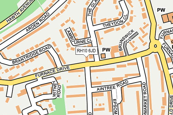
RH10 6JD lies on Furnace Drive in Crawley. RH10 6JD is located in the Furnace Green electoral ward, within the local authority district of Crawley and the English Parliamentary constituency of Crawley. The Sub Integrated Care Board (ICB) Location is NHS Sussex ICB - 70F and the police force is Sussex. This postcode has been in use since January 1980.


GetTheData
Source: OS OpenMap – Local (Ordnance Survey)
Source: OS VectorMap District (Ordnance Survey)
Licence: Open Government Licence (requires attribution)
| Easting | 528020 |
| Northing | 135784 |
| Latitude | 51.107067 |
| Longitude | -0.172718 |
GetTheData
Source: Open Postcode Geo
Licence: Open Government Licence
| Street | Furnace Drive |
| Town/City | Crawley |
| Country | England |
| Postcode District | RH10 |
➜ See where RH10 is on a map ➜ Where is Crawley? | |
GetTheData
Source: Land Registry Price Paid Data
Licence: Open Government Licence
Elevation or altitude of RH10 6JD as distance above sea level:
| Metres | Feet | |
|---|---|---|
| Elevation | 80m | 262ft |
Elevation is measured from the approximate centre of the postcode, to the nearest point on an OS contour line from OS Terrain 50, which has contour spacing of ten vertical metres.
➜ How high above sea level am I? Find the elevation of your current position using your device's GPS.
GetTheData
Source: Open Postcode Elevation
Licence: Open Government Licence
| Ward | Furnace Green |
| Constituency | Crawley |
GetTheData
Source: ONS Postcode Database
Licence: Open Government Licence
45, FURNACE DRIVE, CRAWLEY, RH10 6JD 1997 28 NOV £135,000 |
GetTheData
Source: HM Land Registry Price Paid Data
Licence: Contains HM Land Registry data © Crown copyright and database right 2025. This data is licensed under the Open Government Licence v3.0.
| Brantridge Road (Furnace Drive) | Furnace Green | 48m |
| Brantridge Road (Furnace Drive) | Furnace Green | 98m |
| The Charcoal Burner (Furnace Drive) | Furnace Green | 226m |
| The Charcoal Burner (Weald Drive) | Furnace Green | 261m |
| The Charcoal Burner (Weald Drive) | Furnace Green | 277m |
| Crawley Station | 1.1km |
| Three Bridges Station | 1.4km |
| Ifield Station | 3.1km |
GetTheData
Source: NaPTAN
Licence: Open Government Licence
GetTheData
Source: ONS Postcode Database
Licence: Open Government Licence


➜ Get more ratings from the Food Standards Agency
GetTheData
Source: Food Standards Agency
Licence: FSA terms & conditions
| Last Collection | |||
|---|---|---|---|
| Location | Mon-Fri | Sat | Distance |
| Furnace Drive | 17:00 | 11:15 | 57m |
| The Glade | 17:00 | 11:30 | 224m |
| Furnace Green Parade P O | 17:15 | 11:45 | 291m |
GetTheData
Source: Dracos
Licence: Creative Commons Attribution-ShareAlike
| Risk of RH10 6JD flooding from rivers and sea | High |
| ➜ RH10 6JD flood map | |
GetTheData
Source: Open Flood Risk by Postcode
Licence: Open Government Licence
The below table lists the International Territorial Level (ITL) codes (formerly Nomenclature of Territorial Units for Statistics (NUTS) codes) and Local Administrative Units (LAU) codes for RH10 6JD:
| ITL 1 Code | Name |
|---|---|
| TLJ | South East (England) |
| ITL 2 Code | Name |
| TLJ2 | Surrey, East and West Sussex |
| ITL 3 Code | Name |
| TLJ28 | West Sussex (North East) |
| LAU 1 Code | Name |
| E07000226 | Crawley |
GetTheData
Source: ONS Postcode Directory
Licence: Open Government Licence
The below table lists the Census Output Area (OA), Lower Layer Super Output Area (LSOA), and Middle Layer Super Output Area (MSOA) for RH10 6JD:
| Code | Name | |
|---|---|---|
| OA | E00160950 | |
| LSOA | E01031563 | Crawley 009D |
| MSOA | E02006583 | Crawley 009 |
GetTheData
Source: ONS Postcode Directory
Licence: Open Government Licence
| RH10 6HU | Furnace Drive | 61m |
| RH10 6JL | The Glade | 70m |
| RH10 6JW | Lambourne Close | 87m |
| RH10 6JE | Furnace Drive | 103m |
| RH10 6LR | Aintree Road | 117m |
| RH10 6LP | Cranborne Walk | 136m |
| RH10 6JR | The Glade | 144m |
| RH10 6GJ | Witney Road | 171m |
| RH10 6LS | Aintree Road | 176m |
| RH10 6HT | Brantridge Road | 190m |
GetTheData
Source: Open Postcode Geo; Land Registry Price Paid Data
Licence: Open Government Licence