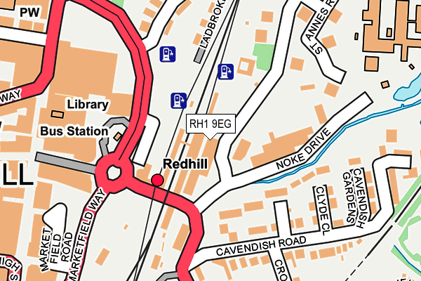
RH1 9EG is located in the Redhill East electoral ward, within the local authority district of Reigate and Banstead and the English Parliamentary constituency of Reigate. The Sub Integrated Care Board (ICB) Location is NHS Surrey Heartlands ICB - 92A and the police force is Surrey. This postcode has been in use since October 2022.


GetTheData
Source: OS OpenMap – Local (Ordnance Survey)
Source: OS VectorMap District (Ordnance Survey)
Licence: Open Government Licence (requires attribution)
| Easting | 528212 |
| Northing | 150643 |
| Latitude | 51.240565 |
| Longitude | -0.164656 |
GetTheData
Source: Open Postcode Geo
Licence: Open Government Licence
| Country | England |
| Postcode District | RH1 |
| ➜ RH1 open data dashboard ➜ See where RH1 is on a map ➜ Where is Redhill? | |
GetTheData
Source: Land Registry Price Paid Data
Licence: Open Government Licence
Elevation or altitude of RH1 9EG as distance above sea level:
| Metres | Feet | |
|---|---|---|
| Elevation | 80m | 262ft |
Elevation is measured from the approximate centre of the postcode, to the nearest point on an OS contour line from OS Terrain 50, which has contour spacing of ten vertical metres.
➜ How high above sea level am I? Find the elevation of your current position using your device's GPS.
GetTheData
Source: Open Postcode Elevation
Licence: Open Government Licence
| Ward | Redhill East |
| Constituency | Reigate |
GetTheData
Source: ONS Postcode Database
Licence: Open Government Licence
| January 2024 | Public order | On or near St Annes Way | 278m |
| January 2024 | Violence and sexual offences | On or near Carrington Close | 495m |
| November 2023 | Drugs | On or near Carrington Close | 495m |
| ➜ Get more crime data in our Crime section | |||
GetTheData
Source: data.police.uk
Licence: Open Government Licence
| Redhill Railway Station (Redstone Hill) | Redhill | 164m |
| St Anne's Mount (St Anne's Drive) | Redhill | 209m |
| Queensway | Redhill | 320m |
| High Street | Redhill | 346m |
| High Street | Redhill | 358m |
| Redhill Station | 0.1km |
| Earlswood (Surrey) Station | 1.5km |
| Nutfield Station | 2.7km |
GetTheData
Source: NaPTAN
Licence: Open Government Licence
GetTheData
Source: ONS Postcode Database
Licence: Open Government Licence


➜ Get more ratings from the Food Standards Agency
GetTheData
Source: Food Standards Agency
Licence: FSA terms & conditions
| Last Collection | |||
|---|---|---|---|
| Location | Mon-Fri | Sat | Distance |
| St Annes Drive Meter Box | 19:00 | 25m | |
| St Annes Drive | 19:00 | 12:45 | 25m |
| Redhill Railway Station | 18:00 | 11:45 | 119m |
GetTheData
Source: Dracos
Licence: Creative Commons Attribution-ShareAlike
| Facility | Distance |
|---|---|
| The Gym Group (Redhill) London Road, Redhill Health and Fitness Gym | 176m |
| Lifeline Fitness (Redhill) (Closed) Tower House, The Bellfry, Redhill Health and Fitness Gym, Studio | 235m |
| Carrington School Noke Drive, Redhill Sports Hall, Artificial Grass Pitch, Grass Pitches, Outdoor Tennis Courts | 291m |
GetTheData
Source: Active Places
Licence: Open Government Licence
| School | Phase of Education | Distance |
|---|---|---|
| Carrington School Noke Drive, Redhill, RH1 4AD | Secondary | 312m |
| St Matthew's CofE Primary School Linkfield Lane, Redhill, RH1 1JF | Primary | 616m |
| St Joseph's Catholic Primary School, Redhill Linkfield Lane, Redhill, RH1 1EA | Primary | 860m |
GetTheData
Source: Edubase
Licence: Open Government Licence
The below table lists the International Territorial Level (ITL) codes (formerly Nomenclature of Territorial Units for Statistics (NUTS) codes) and Local Administrative Units (LAU) codes for RH1 9EG:
| ITL 1 Code | Name |
|---|---|
| TLJ | South East (England) |
| ITL 2 Code | Name |
| TLJ2 | Surrey, East and West Sussex |
| ITL 3 Code | Name |
| TLJ26 | East Surrey |
| LAU 1 Code | Name |
| E07000211 | Reigate and Banstead |
GetTheData
Source: ONS Postcode Directory
Licence: Open Government Licence
The below table lists the Census Output Area (OA), Lower Layer Super Output Area (LSOA), and Middle Layer Super Output Area (MSOA) for RH1 9EG:
| Code | Name | |
|---|---|---|
| OA | E00156117 | |
| LSOA | E01030612 | Reigate and Banstead 011C |
| MSOA | E02006385 | Reigate and Banstead 011 |
GetTheData
Source: ONS Postcode Directory
Licence: Open Government Licence
| RH1 4AZ | Knights Place | 107m |
| RH1 4BH | Venner Close | 119m |
| RH1 4AF | Clyde Close | 147m |
| RH1 4AE | Cavendish Road | 168m |
| RH1 1JZ | Ladbroke Cottages | 171m |
| RH1 1AQ | St Annes Mount | 172m |
| RH1 1NZ | Station Road | 190m |
| RH1 1JQ | Ladbroke Road | 191m |
| RH1 1JY | Ladbroke Road | 198m |
| RH1 1AP | St Annes Mount | 199m |
GetTheData
Source: Open Postcode Geo; Land Registry Price Paid Data
Licence: Open Government Licence