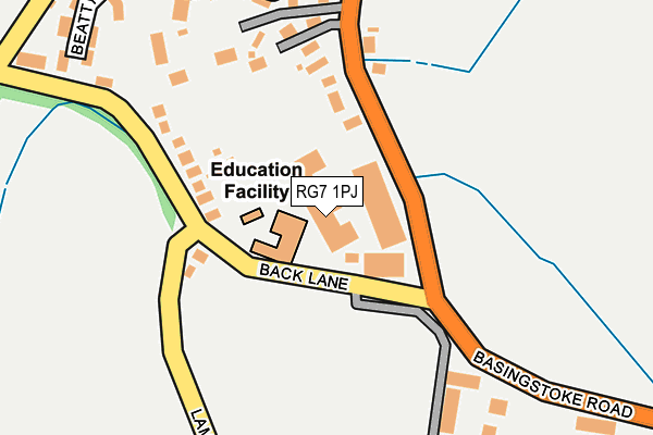
RG7 1PJ is located in the Swallowfield electoral ward, within the unitary authority of Wokingham and the English Parliamentary constituency of Wokingham. The Sub Integrated Care Board (ICB) Location is NHS Buckinghamshire, Oxfordshire and Berkshire West ICB - 15A and the police force is Thames Valley. This postcode has been in use since February 1984.


GetTheData
Source: OS OpenMap – Local (Ordnance Survey)
Source: OS VectorMap District (Ordnance Survey)
Licence: Open Government Licence (requires attribution)
| Easting | 471481 |
| Northing | 165746 |
| Latitude | 51.386268 |
| Longitude | -0.974143 |
GetTheData
Source: Open Postcode Geo
Licence: Open Government Licence
| Country | England |
| Postcode District | RG7 |
| ➜ RG7 open data dashboard ➜ See where RG7 is on a map ➜ Where is Spencers Wood? | |
GetTheData
Source: Land Registry Price Paid Data
Licence: Open Government Licence
Elevation or altitude of RG7 1PJ as distance above sea level:
| Metres | Feet | |
|---|---|---|
| Elevation | 60m | 197ft |
Elevation is measured from the approximate centre of the postcode, to the nearest point on an OS contour line from OS Terrain 50, which has contour spacing of ten vertical metres.
➜ How high above sea level am I? Find the elevation of your current position using your device's GPS.
GetTheData
Source: Open Postcode Elevation
Licence: Open Government Licence
| Ward | Swallowfield |
| Constituency | Wokingham |
GetTheData
Source: ONS Postcode Database
Licence: Open Government Licence
| January 2024 | Public order | On or near Beatty Rise | 308m |
| December 2023 | Public order | On or near Beatty Rise | 308m |
| December 2023 | Public order | On or near Beatty Rise | 308m |
| ➜ Get more crime data in our Crime section | |||
GetTheData
Source: data.police.uk
Licence: Open Government Licence
| Back Lane (Basingstoke Road) | Spencer's Wood | 35m |
| Back Lane (Basingstoke Road) | Spencer's Wood | 49m |
| Lambs Lane | Spencer's Wood | 309m |
| Mobile Home Park East (Beech Hill Road) | Loddon Court Farm | 522m |
| Spencers Wood Post Office (Basingstoke Road) | Spencer's Wood | 577m |
| Mortimer Station | 4.6km |
GetTheData
Source: NaPTAN
Licence: Open Government Licence
Estimated total energy consumption in RG7 1PJ by fuel type, 2015.
| Consumption (kWh) | 153,556 |
|---|---|
| Meter count | 7 |
| Mean (kWh/meter) | 21,937 |
| Median (kWh/meter) | 18,559 |
GetTheData
Source: Postcode level gas estimates: 2015 (experimental)
Source: Postcode level electricity estimates: 2015 (experimental)
Licence: Open Government Licence
GetTheData
Source: ONS Postcode Database
Licence: Open Government Licence


➜ Get more ratings from the Food Standards Agency
GetTheData
Source: Food Standards Agency
Licence: FSA terms & conditions
| Last Collection | |||
|---|---|---|---|
| Location | Mon-Fri | Sat | Distance |
| Spencers Wood Post Office | 17:15 | 10:15 | 689m |
| Swallowfield Post Office | 17:00 | 09:15 | 1,398m |
| Grazeley Church | 17:00 | 07:15 | 1,987m |
GetTheData
Source: Dracos
Licence: Creative Commons Attribution-ShareAlike
| Facility | Distance |
|---|---|
| Lambs Lane Primary School Lambs Lane, Spencers Wood, Reading Grass Pitches | 90m |
| Spencers Wood Recreation Ground Basingstoke Road, Spencers Wood Grass Pitches | 1.3km |
| Swallowfield Recreation Ground Swallowfield Street, Swallowfield, Reading Grass Pitches, Sports Hall | 1.4km |
GetTheData
Source: Active Places
Licence: Open Government Licence
| School | Phase of Education | Distance |
|---|---|---|
| Lambs Lane Primary School Back Lane, Spencers Wood, Spencers Wood, Reading, RG7 1JB | Primary | 159m |
| Grazeley Parochial Church of England Aided Primary School Mereoak Lane, Grazeley, Reading, RG7 1JY | Primary | 1.8km |
| Oakbank Hyde End Lane, Ryeish Green, Reading, RG7 1ER | Secondary | 2km |
GetTheData
Source: Edubase
Licence: Open Government Licence
The below table lists the International Territorial Level (ITL) codes (formerly Nomenclature of Territorial Units for Statistics (NUTS) codes) and Local Administrative Units (LAU) codes for RG7 1PJ:
| ITL 1 Code | Name |
|---|---|
| TLJ | South East (England) |
| ITL 2 Code | Name |
| TLJ1 | Berkshire, Buckinghamshire and Oxfordshire |
| ITL 3 Code | Name |
| TLJ11 | Berkshire |
| LAU 1 Code | Name |
| E06000041 | Wokingham |
GetTheData
Source: ONS Postcode Directory
Licence: Open Government Licence
The below table lists the Census Output Area (OA), Lower Layer Super Output Area (LSOA), and Middle Layer Super Output Area (MSOA) for RG7 1PJ:
| Code | Name | |
|---|---|---|
| OA | E00167037 | |
| LSOA | E01016690 | Wokingham 017C |
| MSOA | E02003455 | Wokingham 017 |
GetTheData
Source: ONS Postcode Directory
Licence: Open Government Licence
| RG7 1PP | Basingstoke Road | 138m |
| RG7 1PS | Basingstoke Road | 140m |
| RG7 1JB | Lambs Lane | 161m |
| RG7 1JD | Lambs Lane | 215m |
| RG7 1FB | Benham Drive | 232m |
| RG7 1FG | Bryant Crescent | 253m |
| RG7 1PH | Basingstoke Road | 299m |
| RG7 1JG | Lambs Lane | 310m |
| RG7 1FQ | Beatty Rise | 329m |
| RG7 1QB | Hill View | 361m |
GetTheData
Source: Open Postcode Geo; Land Registry Price Paid Data
Licence: Open Government Licence