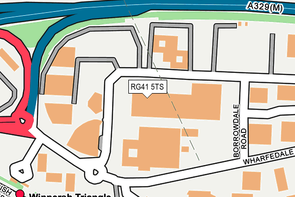
RG41 5TS is located in the Winnersh electoral ward, within the unitary authority of Wokingham and the English Parliamentary constituency of Wokingham. The Sub Integrated Care Board (ICB) Location is NHS Buckinghamshire, Oxfordshire and Berkshire West ICB - 15A and the police force is Thames Valley. This postcode has been in use since July 1995.


GetTheData
Source: OS OpenMap – Local (Ordnance Survey)
Source: OS VectorMap District (Ordnance Survey)
Licence: Open Government Licence (requires attribution)
| Easting | 477427 |
| Northing | 171615 |
| Latitude | 51.438251 |
| Longitude | -0.887435 |
GetTheData
Source: Open Postcode Geo
Licence: Open Government Licence
| Country | England |
| Postcode District | RG41 |
| ➜ RG41 open data dashboard ➜ See where RG41 is on a map ➜ Where is Winnersh? | |
GetTheData
Source: Land Registry Price Paid Data
Licence: Open Government Licence
Elevation or altitude of RG41 5TS as distance above sea level:
| Metres | Feet | |
|---|---|---|
| Elevation | 40m | 131ft |
Elevation is measured from the approximate centre of the postcode, to the nearest point on an OS contour line from OS Terrain 50, which has contour spacing of ten vertical metres.
➜ How high above sea level am I? Find the elevation of your current position using your device's GPS.
GetTheData
Source: Open Postcode Elevation
Licence: Open Government Licence
| Ward | Winnersh |
| Constituency | Wokingham |
GetTheData
Source: ONS Postcode Database
Licence: Open Government Licence
| March 2023 | Vehicle crime | On or near Albany Park Drive | 423m |
| June 2022 | Vehicle crime | On or near Verbena Close | 319m |
| June 2022 | Other crime | On or near Albany Park Drive | 423m |
| ➜ Get more crime data in our Crime section | |||
GetTheData
Source: data.police.uk
Licence: Open Government Licence
| Winnersh Triangle Railway Station (Wharfedale Road) | Winnersh Triangle | 199m |
| Winnersh Triangle Railway Station (Forecourt) | Winnersh Triangle | 316m |
| Cavendish Gardens (Reading Road) | Loddon Bridge | 426m |
| Cavendish Gardens (Reading Road) | Loddon Bridge | 434m |
| Drome Path (Reading Road) | Winnersh | 472m |
| Winnersh Triangle Station | 0.3km |
| Winnersh Station | 1.2km |
| Earley Station | 2.1km |
GetTheData
Source: NaPTAN
Licence: Open Government Licence
| Median download speed | 2.6Mbps |
| Average download speed | 2.6Mbps |
| Maximum download speed | 3.38Mbps |
| Median upload speed | 0.9Mbps |
| Average upload speed | 0.8Mbps |
| Maximum upload speed | 1.05Mbps |
GetTheData
Source: Ofcom
Licence: Ofcom Terms of Use (requires attribution)
Estimated total energy consumption in RG41 5TS by fuel type, 2015.
| Consumption (kWh) | 337,207 |
|---|---|
| Meter count | 9 |
| Mean (kWh/meter) | 37,467 |
| Median (kWh/meter) | 45,416 |
GetTheData
Source: Postcode level gas estimates: 2015 (experimental)
Source: Postcode level electricity estimates: 2015 (experimental)
Licence: Open Government Licence
GetTheData
Source: ONS Postcode Database
Licence: Open Government Licence


➜ Get more ratings from the Food Standards Agency
GetTheData
Source: Food Standards Agency
Licence: FSA terms & conditions
| Last Collection | |||
|---|---|---|---|
| Location | Mon-Fri | Sat | Distance |
| Wharfdale Road | 18:30 | 11:30 | 180m |
| Wharfedale Road | 180m | ||
| Holly Road | 16:15 | 11:00 | 1,018m |
GetTheData
Source: Dracos
Licence: Creative Commons Attribution-ShareAlike
| Facility | Distance |
|---|---|
| Esprit Spa & Wellness Wharfedale Road, Winnersh Triangle, Reading Health and Fitness Gym, Swimming Pool | 155m |
| Move Hq Eskdale Road, Winnersh, Wokingham Health and Fitness Gym, Artificial Grass Pitch, Studio | 225m |
| The Forest School (Winnersh) Robin Hood Lane, Winnersh, Wokingham Grass Pitches, Sports Hall, Swimming Pool, Outdoor Tennis Courts, Studio, Artificial Grass Pitch | 1km |
GetTheData
Source: Active Places
Licence: Open Government Licence
| School | Phase of Education | Distance |
|---|---|---|
| The Forest School Robin Hood Lane, Winnersh, Wokingham, RG41 5NE | Secondary | 1km |
| Winnersh Primary School Greenwood Grove, Winnersh, Wokingham, RG41 5LH | Primary | 1.3km |
| Rivermead Primary School Loddon Bridge Road, Woodley, Reading, RG5 4BS | Primary | 1.3km |
GetTheData
Source: Edubase
Licence: Open Government Licence
The below table lists the International Territorial Level (ITL) codes (formerly Nomenclature of Territorial Units for Statistics (NUTS) codes) and Local Administrative Units (LAU) codes for RG41 5TS:
| ITL 1 Code | Name |
|---|---|
| TLJ | South East (England) |
| ITL 2 Code | Name |
| TLJ1 | Berkshire, Buckinghamshire and Oxfordshire |
| ITL 3 Code | Name |
| TLJ11 | Berkshire |
| LAU 1 Code | Name |
| E06000041 | Wokingham |
GetTheData
Source: ONS Postcode Directory
Licence: Open Government Licence
The below table lists the Census Output Area (OA), Lower Layer Super Output Area (LSOA), and Middle Layer Super Output Area (MSOA) for RG41 5TS:
| Code | Name | |
|---|---|---|
| OA | E00084279 | |
| LSOA | E01016702 | Wokingham 009C |
| MSOA | E02003447 | Wokingham 009 |
GetTheData
Source: ONS Postcode Directory
Licence: Open Government Licence
| RG41 5ST | Verbena Close | 341m |
| RG41 5RD | Wharfedale Road | 345m |
| RG41 5RT | The Old Apple Yard | 363m |
| RG41 5TG | Cavendish Gardens | 370m |
| RG41 5TQ | Belvedere Walk | 387m |
| RG41 5TE | Fenchurch Mews | 400m |
| RG41 5HJ | Reading Road | 426m |
| RG41 5HZ | Albany Park Drive | 430m |
| RG41 5HQ | Reading Road | 447m |
| RG41 5ED | Arbor Meadows | 450m |
GetTheData
Source: Open Postcode Geo; Land Registry Price Paid Data
Licence: Open Government Licence