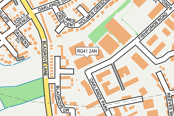
RG41 2AN lies on Fishponds Road in Wokingham. RG41 2AN is located in the Evendons electoral ward, within the unitary authority of Wokingham and the English Parliamentary constituency of Wokingham. The Sub Integrated Care Board (ICB) Location is NHS Buckinghamshire, Oxfordshire and Berkshire West ICB - 15A and the police force is Thames Valley. This postcode has been in use since September 2009.


GetTheData
Source: OS OpenMap – Local (Ordnance Survey)
Source: OS VectorMap District (Ordnance Survey)
Licence: Open Government Licence (requires attribution)
| Easting | 480033 |
| Northing | 167753 |
| Latitude | 51.403170 |
| Longitude | -0.850840 |
GetTheData
Source: Open Postcode Geo
Licence: Open Government Licence
| Street | Fishponds Road |
| Town/City | Wokingham |
| Country | England |
| Postcode District | RG41 |
| ➜ RG41 open data dashboard ➜ See where RG41 is on a map ➜ Where is Wokingham? | |
GetTheData
Source: Land Registry Price Paid Data
Licence: Open Government Licence
Elevation or altitude of RG41 2AN as distance above sea level:
| Metres | Feet | |
|---|---|---|
| Elevation | 60m | 197ft |
Elevation is measured from the approximate centre of the postcode, to the nearest point on an OS contour line from OS Terrain 50, which has contour spacing of ten vertical metres.
➜ How high above sea level am I? Find the elevation of your current position using your device's GPS.
GetTheData
Source: Open Postcode Elevation
Licence: Open Government Licence
| Ward | Evendons |
| Constituency | Wokingham |
GetTheData
Source: ONS Postcode Database
Licence: Open Government Licence
| June 2022 | Violence and sexual offences | On or near Blagrove Drive | 144m |
| June 2022 | Violence and sexual offences | On or near Blagrove Drive | 144m |
| June 2022 | Violence and sexual offences | On or near Blagrove Drive | 144m |
| ➜ Fishponds Road crime map and outcomes | |||
GetTheData
Source: data.police.uk
Licence: Open Government Licence
| Mulberry Business Park (Fishponds Road) | Wokingham | 39m |
| Mulberry Business Park (Fishponds Road) | Wokingham | 65m |
| Oaklands Park | Wokingham | 273m |
| Fishponds Close (Fishponds Road) | Wokingham | 361m |
| Fishponds Close (Fishponds Road) | Wokingham | 364m |
| Wokingham Station | 1.1km |
| Winnersh Station | 3.5km |
| Crowthorne Station | 4.6km |
GetTheData
Source: NaPTAN
Licence: Open Government Licence
| Median download speed | 10.2Mbps |
| Average download speed | 10.1Mbps |
| Maximum download speed | 15.52Mbps |
| Median upload speed | 1.0Mbps |
| Average upload speed | 1.0Mbps |
| Maximum upload speed | 1.11Mbps |
GetTheData
Source: Ofcom
Licence: Ofcom Terms of Use (requires attribution)
GetTheData
Source: ONS Postcode Database
Licence: Open Government Licence


➜ Get more ratings from the Food Standards Agency
GetTheData
Source: Food Standards Agency
Licence: FSA terms & conditions
| Last Collection | |||
|---|---|---|---|
| Location | Mon-Fri | Sat | Distance |
| Oaklands Drive | 16:00 | 11:45 | 351m |
| Fishponds Road | 352m | ||
| Eastheath Avenue | 16:00 | 11:00 | 356m |
GetTheData
Source: Dracos
Licence: Creative Commons Attribution-ShareAlike
| Facility | Distance |
|---|---|
| Barkham Park Latimer Road, Wokingham Grass Pitches | 858m |
| Luckley House School Luckley Road, Wokingham Swimming Pool, Sports Hall, Grass Pitches, Artificial Grass Pitch | 933m |
| Wokingham Cricket Club (Closed) Wellington Road, Wokingham Grass Pitches, Outdoor Tennis Courts | 937m |
GetTheData
Source: Active Places
Licence: Open Government Licence
| School | Phase of Education | Distance |
|---|---|---|
| CAMHS Phoenix School CAMHS Phoenix Unit, Wokingham Hospital, Barkham Road, Wokingham, RG41 2RE | Not applicable | 791m |
| Evendons Primary School 161 Finchampstead Road, Wokingham, RG40 3HD | Primary | 847m |
| Luckley House School Luckley Road, Wokingham, Berkshire, RG40 3EU | Not applicable | 933m |
GetTheData
Source: Edubase
Licence: Open Government Licence
The below table lists the International Territorial Level (ITL) codes (formerly Nomenclature of Territorial Units for Statistics (NUTS) codes) and Local Administrative Units (LAU) codes for RG41 2AN:
| ITL 1 Code | Name |
|---|---|
| TLJ | South East (England) |
| ITL 2 Code | Name |
| TLJ1 | Berkshire, Buckinghamshire and Oxfordshire |
| ITL 3 Code | Name |
| TLJ11 | Berkshire |
| LAU 1 Code | Name |
| E06000041 | Wokingham |
GetTheData
Source: ONS Postcode Directory
Licence: Open Government Licence
The below table lists the Census Output Area (OA), Lower Layer Super Output Area (LSOA), and Middle Layer Super Output Area (MSOA) for RG41 2AN:
| Code | Name | |
|---|---|---|
| OA | E00083967 | |
| LSOA | E01016634 | Wokingham 016D |
| MSOA | E02003454 | Wokingham 016 |
GetTheData
Source: ONS Postcode Directory
Licence: Open Government Licence
| RG41 4BD | Blagrove Drive | 102m |
| RG41 4BA | Blagrove Lane | 121m |
| RG41 2SD | Holmes Crescent | 136m |
| RG41 2SG | Holmes Close | 176m |
| RG41 2SE | Holmes Crescent | 192m |
| RG41 4EJ | Daubeny Close | 211m |
| RG41 4BB | Blagrove Drive | 220m |
| RG41 2FD | Oaklands Park | 245m |
| RG41 2SB | Oaklands Drive | 269m |
| RG41 4BE | Blagrove Lane | 291m |
GetTheData
Source: Open Postcode Geo; Land Registry Price Paid Data
Licence: Open Government Licence