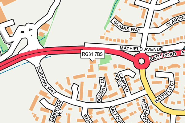
RG31 7BS is located in the Tilehurst South & Holybrook electoral ward, within the unitary authority of West Berkshire and the English Parliamentary constituency of Reading West. The Sub Integrated Care Board (ICB) Location is NHS Buckinghamshire, Oxfordshire and Berkshire West ICB - 15A and the police force is Thames Valley. This postcode has been in use since June 1999.


GetTheData
Source: OS OpenMap – Local (Ordnance Survey)
Source: OS VectorMap District (Ordnance Survey)
Licence: Open Government Licence (requires attribution)
| Easting | 465567 |
| Northing | 171722 |
| Latitude | 51.440706 |
| Longitude | -1.058036 |
GetTheData
Source: Open Postcode Geo
Licence: Open Government Licence
| Country | England |
| Postcode District | RG31 |
| ➜ RG31 open data dashboard ➜ See where RG31 is on a map ➜ Where is Reading? | |
GetTheData
Source: Land Registry Price Paid Data
Licence: Open Government Licence
Elevation or altitude of RG31 7BS as distance above sea level:
| Metres | Feet | |
|---|---|---|
| Elevation | 50m | 164ft |
Elevation is measured from the approximate centre of the postcode, to the nearest point on an OS contour line from OS Terrain 50, which has contour spacing of ten vertical metres.
➜ How high above sea level am I? Find the elevation of your current position using your device's GPS.
GetTheData
Source: Open Postcode Elevation
Licence: Open Government Licence
| Ward | Tilehurst South & Holybrook |
| Constituency | Reading West |
GetTheData
Source: ONS Postcode Database
Licence: Open Government Licence
| November 2023 | Violence and sexual offences | On or near Charlville Drive | 333m |
| November 2023 | Anti-social behaviour | On or near Charrington Road | 498m |
| October 2023 | Violence and sexual offences | On or near Piercefield | 483m |
| ➜ Get more crime data in our Crime section | |||
GetTheData
Source: data.police.uk
Licence: Open Government Licence
| Mayfield Avenue (A4 Bath Road) | Calcot | 52m |
| Mayfield Avenue (A4 Bath Road) | Calcot | 80m |
| Calcot Post Office (Royal Avenue) | Calcot | 208m |
| Calcot Sainsbury's (Pincents Lane) | Calcot | 221m |
| Calcot Sainsbury's (Pincents Lane) | Calcot | 232m |
| Theale Station | 1.4km |
| Tilehurst Station | 3.9km |
| Reading West Station | 5km |
GetTheData
Source: NaPTAN
Licence: Open Government Licence
GetTheData
Source: ONS Postcode Database
Licence: Open Government Licence


➜ Get more ratings from the Food Standards Agency
GetTheData
Source: Food Standards Agency
Licence: FSA terms & conditions
| Last Collection | |||
|---|---|---|---|
| Location | Mon-Fri | Sat | Distance |
| Langley Hill | 16:00 | 13:30 | 1,034m |
| Calbourne Drive | 16:00 | 13:15 | 1,206m |
| Theale Church | 16:00 | 09:00 | 1,578m |
GetTheData
Source: Dracos
Licence: Creative Commons Attribution-ShareAlike
| Facility | Distance |
|---|---|
| Puregym (Reading Calcot) Bath Road, Bath Road, Calcot, Reading Health and Fitness Gym | 320m |
| Calcot Recreation Ground High View, Calcot, Reading Grass Pitches | 460m |
| Calcot Junior School Curtis Road, Calcot, Reading Grass Pitches, Swimming Pool | 484m |
GetTheData
Source: Active Places
Licence: Open Government Licence
| School | Phase of Education | Distance |
|---|---|---|
| Calcot Infant School and Nursery Curtis Road, Calcot, Reading, RG31 4XG | Primary | 535m |
| Calcot Junior School Curtis Road, Calcot, Reading, RG31 4XG | Primary | 535m |
| Springfield Primary School Barton Road, Tilehurst, Reading, RG31 5NJ | Primary | 1.4km |
GetTheData
Source: Edubase
Licence: Open Government Licence
The below table lists the International Territorial Level (ITL) codes (formerly Nomenclature of Territorial Units for Statistics (NUTS) codes) and Local Administrative Units (LAU) codes for RG31 7BS:
| ITL 1 Code | Name |
|---|---|
| TLJ | South East (England) |
| ITL 2 Code | Name |
| TLJ1 | Berkshire, Buckinghamshire and Oxfordshire |
| ITL 3 Code | Name |
| TLJ11 | Berkshire |
| LAU 1 Code | Name |
| E06000037 | West Berkshire |
GetTheData
Source: ONS Postcode Directory
Licence: Open Government Licence
The below table lists the Census Output Area (OA), Lower Layer Super Output Area (LSOA), and Middle Layer Super Output Area (MSOA) for RG31 7BS:
| Code | Name | |
|---|---|---|
| OA | E00082210 | |
| LSOA | E01016276 | West Berkshire 008D |
| MSOA | E02003374 | West Berkshire 008 |
GetTheData
Source: ONS Postcode Directory
Licence: Open Government Licence
| RG31 7BB | Blackwater Rise | 86m |
| RG31 7BD | Bourne Close | 86m |
| RG31 7AG | Camden Place | 101m |
| RG31 7AF | Camden Place | 117m |
| RG31 4UX | Glamis Way | 160m |
| RG31 7AE | Dorking Way | 166m |
| RG31 7BQ | Silbury Close | 191m |
| RG31 7BL | Bamford Place | 195m |
| RG31 7BG | Embrook Way | 217m |
| RG31 7AL | Hatfield Court | 220m |
GetTheData
Source: Open Postcode Geo; Land Registry Price Paid Data
Licence: Open Government Licence