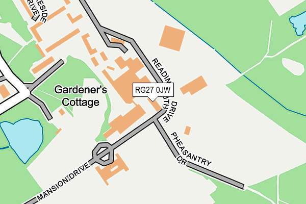
RG27 0JW is located in the Hartley Wintney electoral ward, within the local authority district of Hart and the English Parliamentary constituency of North East Hampshire. The Sub Integrated Care Board (ICB) Location is NHS Hampshire and Isle of Wight ICB - D9Y0V and the police force is Hampshire. This postcode has been in use since January 1980.


GetTheData
Source: OS OpenMap – Local (Ordnance Survey)
Source: OS VectorMap District (Ordnance Survey)
Licence: Open Government Licence (requires attribution)
| Easting | 475958 |
| Northing | 159761 |
| Latitude | 51.331881 |
| Longitude | -0.911116 |
GetTheData
Source: Open Postcode Geo
Licence: Open Government Licence
| Country | England |
| Postcode District | RG27 |
➜ See where RG27 is on a map | |
GetTheData
Source: Land Registry Price Paid Data
Licence: Open Government Licence
Elevation or altitude of RG27 0JW as distance above sea level:
| Metres | Feet | |
|---|---|---|
| Elevation | 80m | 262ft |
Elevation is measured from the approximate centre of the postcode, to the nearest point on an OS contour line from OS Terrain 50, which has contour spacing of ten vertical metres.
➜ How high above sea level am I? Find the elevation of your current position using your device's GPS.
GetTheData
Source: Open Postcode Elevation
Licence: Open Government Licence
| Ward | Hartley Wintney |
| Constituency | North East Hampshire |
GetTheData
Source: ONS Postcode Database
Licence: Open Government Licence
| Plough Lane (Bramshill Road) | Bramshill | 1,523m |
| Red Hill (B3011) | Hazeley | 1,696m |
| Little Cottage (B3011) | Hazeley Heath | 1,698m |
| Little Cottage (B3011) | Hazeley Heath | 1,704m |
| Red Hill (B3011) | Hazeley | 1,724m |
GetTheData
Source: NaPTAN
Licence: Open Government Licence
GetTheData
Source: ONS Postcode Database
Licence: Open Government Licence


➜ Get more ratings from the Food Standards Agency
GetTheData
Source: Food Standards Agency
Licence: FSA terms & conditions
| Last Collection | |||
|---|---|---|---|
| Location | Mon-Fri | Sat | Distance |
| Shoulder Of Mutton | 16:15 | 08:00 | 1,812m |
| Hazeley Bottom | 16:15 | 07:30 | 2,062m |
| Eversley Church | 16:30 | 07:45 | 2,378m |
GetTheData
Source: Dracos
Licence: Creative Commons Attribution-ShareAlike
The below table lists the International Territorial Level (ITL) codes (formerly Nomenclature of Territorial Units for Statistics (NUTS) codes) and Local Administrative Units (LAU) codes for RG27 0JW:
| ITL 1 Code | Name |
|---|---|
| TLJ | South East (England) |
| ITL 2 Code | Name |
| TLJ3 | Hampshire and Isle of Wight |
| ITL 3 Code | Name |
| TLJ37 | North Hampshire |
| LAU 1 Code | Name |
| E07000089 | Hart |
GetTheData
Source: ONS Postcode Directory
Licence: Open Government Licence
The below table lists the Census Output Area (OA), Lower Layer Super Output Area (LSOA), and Middle Layer Super Output Area (MSOA) for RG27 0JW:
| Code | Name | |
|---|---|---|
| OA | E00116150 | |
| LSOA | E01022858 | Hart 004A |
| MSOA | E02004754 | Hart 004 |
GetTheData
Source: ONS Postcode Directory
Licence: Open Government Licence
| RG27 0JU | Lakeside Drive | 334m |
| RG27 0JN | Bramshill Park | 906m |
| RG27 0RF | Plough Lane | 1177m |
| RG27 8ND | Hazeley Lea | 1376m |
| RG27 8LT | 1489m | |
| RG27 8LZ | 1622m | |
| RG27 0RG | Bramshill Road | 1687m |
| RG27 8NB | 1775m | |
| RG27 8NA | 1842m | |
| RG27 8LY | 1856m |
GetTheData
Source: Open Postcode Geo; Land Registry Price Paid Data
Licence: Open Government Licence