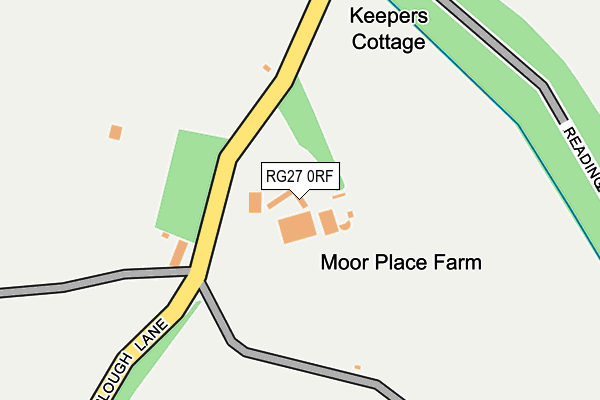
RG27 0RF lies on Plough Lane in Bramshill, Hook. RG27 0RF is located in the Hartley Wintney electoral ward, within the local authority district of Hart and the English Parliamentary constituency of North East Hampshire. The Sub Integrated Care Board (ICB) Location is NHS Hampshire and Isle of Wight ICB - D9Y0V and the police force is Hampshire. This postcode has been in use since January 1980.


GetTheData
Source: OS OpenMap – Local (Ordnance Survey)
Source: OS VectorMap District (Ordnance Survey)
Licence: Open Government Licence (requires attribution)
| Easting | 475303 |
| Northing | 160739 |
| Latitude | 51.340761 |
| Longitude | -0.920291 |
GetTheData
Source: Open Postcode Geo
Licence: Open Government Licence
| Street | Plough Lane |
| Locality | Bramshill |
| Town/City | Hook |
| Country | England |
| Postcode District | RG27 |
➜ See where RG27 is on a map | |
GetTheData
Source: Land Registry Price Paid Data
Licence: Open Government Licence
Elevation or altitude of RG27 0RF as distance above sea level:
| Metres | Feet | |
|---|---|---|
| Elevation | 70m | 230ft |
Elevation is measured from the approximate centre of the postcode, to the nearest point on an OS contour line from OS Terrain 50, which has contour spacing of ten vertical metres.
➜ How high above sea level am I? Find the elevation of your current position using your device's GPS.
GetTheData
Source: Open Postcode Elevation
Licence: Open Government Licence
| Ward | Hartley Wintney |
| Constituency | North East Hampshire |
GetTheData
Source: ONS Postcode Database
Licence: Open Government Licence
| Plough Lane (Bramshill Road) | Bramshill | 636m |
| Plough Lane (Bramshill Road) | Bramshill | 650m |
| The Hatch Gate (Glaston Hill Road) | Bramshill | 1,033m |
| The Hatch Gate (Glaston Hill Road) | Bramshill | 1,076m |
| Holdshott Farm (B3011) | Bramshill | 1,517m |
GetTheData
Source: NaPTAN
Licence: Open Government Licence
| Percentage of properties with Next Generation Access | 100.0% |
| Percentage of properties with Superfast Broadband | 0.0% |
| Percentage of properties with Ultrafast Broadband | 0.0% |
| Percentage of properties with Full Fibre Broadband | 0.0% |
Superfast Broadband is between 30Mbps and 300Mbps
Ultrafast Broadband is > 300Mbps
| Median download speed | 8.0Mbps |
| Average download speed | 7.3Mbps |
| Maximum download speed | 9.74Mbps |
| Median upload speed | 1.1Mbps |
| Average upload speed | 0.9Mbps |
| Maximum upload speed | 1.19Mbps |
| Percentage of properties unable to receive 2Mbps | 0.0% |
| Percentage of properties unable to receive 5Mbps | 11.1% |
| Percentage of properties unable to receive 10Mbps | 100.0% |
| Percentage of properties unable to receive 30Mbps | 100.0% |
GetTheData
Source: Ofcom
Licence: Ofcom Terms of Use (requires attribution)
Estimated total energy consumption in RG27 0RF by fuel type, 2015.
| Consumption (kWh) | 64,983 |
|---|---|
| Meter count | 6 |
| Mean (kWh/meter) | 10,831 |
| Median (kWh/meter) | 6,293 |
GetTheData
Source: Postcode level gas estimates: 2015 (experimental)
Source: Postcode level electricity estimates: 2015 (experimental)
Licence: Open Government Licence
GetTheData
Source: ONS Postcode Database
Licence: Open Government Licence


➜ Get more ratings from the Food Standards Agency
GetTheData
Source: Food Standards Agency
Licence: FSA terms & conditions
| Last Collection | |||
|---|---|---|---|
| Location | Mon-Fri | Sat | Distance |
| Shoulder Of Mutton | 16:15 | 08:00 | 1,948m |
| Eversley Church | 16:30 | 07:45 | 2,704m |
| Vicarage Road, Hound Green | 16:00 | 07:45 | 2,807m |
GetTheData
Source: Dracos
Licence: Creative Commons Attribution-ShareAlike
The below table lists the International Territorial Level (ITL) codes (formerly Nomenclature of Territorial Units for Statistics (NUTS) codes) and Local Administrative Units (LAU) codes for RG27 0RF:
| ITL 1 Code | Name |
|---|---|
| TLJ | South East (England) |
| ITL 2 Code | Name |
| TLJ3 | Hampshire and Isle of Wight |
| ITL 3 Code | Name |
| TLJ37 | North Hampshire |
| LAU 1 Code | Name |
| E07000089 | Hart |
GetTheData
Source: ONS Postcode Directory
Licence: Open Government Licence
The below table lists the Census Output Area (OA), Lower Layer Super Output Area (LSOA), and Middle Layer Super Output Area (MSOA) for RG27 0RF:
| Code | Name | |
|---|---|---|
| OA | E00116150 | |
| LSOA | E01022858 | Hart 004A |
| MSOA | E02004754 | Hart 004 |
GetTheData
Source: ONS Postcode Directory
Licence: Open Government Licence
| RG27 0RG | Bramshill Road | 509m |
| RG27 0JU | Lakeside Drive | 865m |
| RG27 0RQ | Copes Lane | 923m |
| RG27 8ND | Hazeley Lea | 1362m |
| RG27 0JZ | Reading Road | 1377m |
| RG27 0LA | Bramshill Road | 1549m |
| RG27 0PW | St Neots Road | 1593m |
| RG27 0PN | St Neots Road | 1735m |
| RG27 8LZ | 1790m | |
| RG27 8NB | 1830m |
GetTheData
Source: Open Postcode Geo; Land Registry Price Paid Data
Licence: Open Government Licence