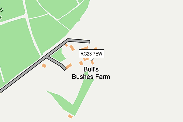
RG23 7EW is in Oakley, Basingstoke. RG23 7EW is located in the Oakley & The Candovers electoral ward, within the local authority district of Basingstoke and Deane and the English Parliamentary constituency of North West Hampshire. The Sub Integrated Care Board (ICB) Location is NHS Hampshire and Isle of Wight ICB - D9Y0V and the police force is Hampshire. This postcode has been in use since February 2004.


GetTheData
Source: OS OpenMap – Local (Ordnance Survey)
Source: OS VectorMap District (Ordnance Survey)
Licence: Open Government Licence (requires attribution)
| Easting | 457349 |
| Northing | 148646 |
| Latitude | 51.234124 |
| Longitude | -1.179951 |
GetTheData
Source: Open Postcode Geo
Licence: Open Government Licence
| Locality | Oakley |
| Town/City | Basingstoke |
| Country | England |
| Postcode District | RG23 |
| ➜ RG23 open data dashboard ➜ See where RG23 is on a map | |
GetTheData
Source: Land Registry Price Paid Data
Licence: Open Government Licence
Elevation or altitude of RG23 7EW as distance above sea level:
| Metres | Feet | |
|---|---|---|
| Elevation | 140m | 459ft |
Elevation is measured from the approximate centre of the postcode, to the nearest point on an OS contour line from OS Terrain 50, which has contour spacing of ten vertical metres.
➜ How high above sea level am I? Find the elevation of your current position using your device's GPS.
GetTheData
Source: Open Postcode Elevation
Licence: Open Government Licence
| Ward | Oakley & The Candovers |
| Constituency | North West Hampshire |
GetTheData
Source: ONS Postcode Database
Licence: Open Government Licence
| Pardown (Hill Road) | East Oakley | 1,238m |
| Sainfoin Lane (Hill Road) | East Oakley | 1,238m |
| Sainfoin Lane (Hill Road) | East Oakley | 1,239m |
| Pardown (Hill Road) | East Oakley | 1,244m |
| Barn Lane (Hill Road) | East Oakley | 1,356m |
GetTheData
Source: NaPTAN
Licence: Open Government Licence
GetTheData
Source: ONS Postcode Database
Licence: Open Government Licence

➜ Get more ratings from the Food Standards Agency
GetTheData
Source: Food Standards Agency
Licence: FSA terms & conditions
| Last Collection | |||
|---|---|---|---|
| Location | Mon-Fri | Sat | Distance |
| Claypits | 16:45 | 10:00 | 1,292m |
| Kennet Way | 16:45 | 10:00 | 1,567m |
| Oakley Post Office | 17:15 | 10:45 | 1,625m |
GetTheData
Source: Dracos
Licence: Creative Commons Attribution-ShareAlike
| Facility | Distance |
|---|---|
| Oakley Park Trenchard Lane, Oakley Grass Pitches | 1km |
| Peter Houseman Ground Rectory Road, Oakley Grass Pitches | 1.8km |
| Basingstoke Golf Club (Closed) Kempshott Hill, Kempshott, Basingstoke Golf | 2.4km |
GetTheData
Source: Active Places
Licence: Open Government Licence
| School | Phase of Education | Distance |
|---|---|---|
| Oakley Church of England Junior School Oakley Lane, Oakley, Basingstoke, RG23 7JZ | Primary | 1.5km |
| Oakley Infant School Oakley Lane, Oakley, Basingstoke, RG23 7JZ | Primary | 1.7km |
| North Waltham Primary School Church Road, North Waltham, Basingstoke, RG25 2BL | Primary | 2.5km |
GetTheData
Source: Edubase
Licence: Open Government Licence
The below table lists the International Territorial Level (ITL) codes (formerly Nomenclature of Territorial Units for Statistics (NUTS) codes) and Local Administrative Units (LAU) codes for RG23 7EW:
| ITL 1 Code | Name |
|---|---|
| TLJ | South East (England) |
| ITL 2 Code | Name |
| TLJ3 | Hampshire and Isle of Wight |
| ITL 3 Code | Name |
| TLJ37 | North Hampshire |
| LAU 1 Code | Name |
| E07000084 | Basingstoke and Deane |
GetTheData
Source: ONS Postcode Directory
Licence: Open Government Licence
The below table lists the Census Output Area (OA), Lower Layer Super Output Area (LSOA), and Middle Layer Super Output Area (MSOA) for RG23 7EW:
| Code | Name | |
|---|---|---|
| OA | E00114550 | |
| LSOA | E01022529 | Basingstoke and Deane 015B |
| MSOA | E02004689 | Basingstoke and Deane 015 |
GetTheData
Source: ONS Postcode Directory
Licence: Open Government Licence
| RG23 7EB | 80m | |
| RG23 7DZ | Pardown | 693m |
| RG23 7JE | Fairview Meadow | 1008m |
| RG23 7EF | Beech Tree Close | 1022m |
| RG23 7EE | Ash Tree Close | 1042m |
| RG23 7HZ | Sainfoin Lane | 1057m |
| RG23 7JB | Sunnymead | 1080m |
| RG23 7HX | Water Ridges | 1094m |
| RG23 7JA | Water Ridges | 1107m |
| RG23 7HY | Sainfoin Lane | 1111m |
GetTheData
Source: Open Postcode Geo; Land Registry Price Paid Data
Licence: Open Government Licence