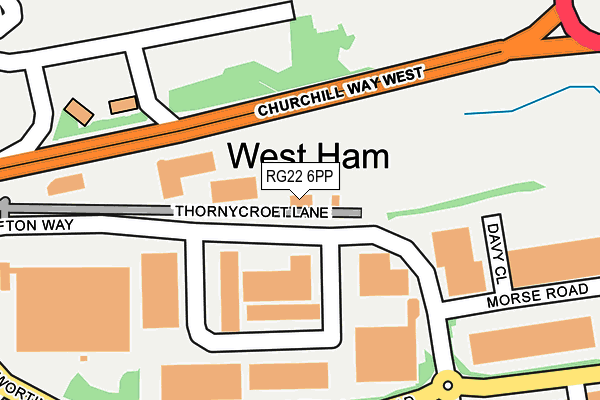
RG22 6PP is located in the South Ham electoral ward, within the local authority district of Basingstoke and Deane and the English Parliamentary constituency of Basingstoke. The Sub Integrated Care Board (ICB) Location is NHS Hampshire and Isle of Wight ICB - D9Y0V and the police force is Hampshire. This postcode has been in use since January 1980.


GetTheData
Source: OS OpenMap – Local (Ordnance Survey)
Source: OS VectorMap District (Ordnance Survey)
Licence: Open Government Licence (requires attribution)
| Easting | 462062 |
| Northing | 152012 |
| Latitude | 51.263895 |
| Longitude | -1.111871 |
GetTheData
Source: Open Postcode Geo
Licence: Open Government Licence
| Country | England |
| Postcode District | RG22 |
➜ See where RG22 is on a map ➜ Where is Basingstoke? | |
GetTheData
Source: Land Registry Price Paid Data
Licence: Open Government Licence
Elevation or altitude of RG22 6PP as distance above sea level:
| Metres | Feet | |
|---|---|---|
| Elevation | 90m | 295ft |
Elevation is measured from the approximate centre of the postcode, to the nearest point on an OS contour line from OS Terrain 50, which has contour spacing of ten vertical metres.
➜ How high above sea level am I? Find the elevation of your current position using your device's GPS.
GetTheData
Source: Open Postcode Elevation
Licence: Open Government Licence
| Ward | South Ham |
| Constituency | Basingstoke |
GetTheData
Source: ONS Postcode Database
Licence: Open Government Licence
| Sandys Road Roundabout (Worting Road) | South Ham | 241m |
| Sandys Road Roundabout (Worting Road) | South Ham | 261m |
| Milestones (Off Euskirchen Way) | West Ham | 279m |
| Charles Street (St Peter's Road) | South Ham | 342m |
| Old Worting Road (Worting Road) | West Ham | 352m |
| Basingstoke Station | 1.8km |
GetTheData
Source: NaPTAN
Licence: Open Government Licence
GetTheData
Source: ONS Postcode Database
Licence: Open Government Licence


➜ Get more ratings from the Food Standards Agency
GetTheData
Source: Food Standards Agency
Licence: FSA terms & conditions
| Last Collection | |||
|---|---|---|---|
| Location | Mon-Fri | Sat | Distance |
| Overbridge | 16:45 | 11:00 | 303m |
| Charles Street | 16:15 | 10:30 | 353m |
| Willoughby Way | 16:00 | 10:30 | 663m |
GetTheData
Source: Dracos
Licence: Creative Commons Attribution-ShareAlike
| Risk of RG22 6PP flooding from rivers and sea | Medium |
| ➜ RG22 6PP flood map | |
GetTheData
Source: Open Flood Risk by Postcode
Licence: Open Government Licence
The below table lists the International Territorial Level (ITL) codes (formerly Nomenclature of Territorial Units for Statistics (NUTS) codes) and Local Administrative Units (LAU) codes for RG22 6PP:
| ITL 1 Code | Name |
|---|---|
| TLJ | South East (England) |
| ITL 2 Code | Name |
| TLJ3 | Hampshire and Isle of Wight |
| ITL 3 Code | Name |
| TLJ37 | North Hampshire |
| LAU 1 Code | Name |
| E07000084 | Basingstoke and Deane |
GetTheData
Source: ONS Postcode Directory
Licence: Open Government Licence
The below table lists the Census Output Area (OA), Lower Layer Super Output Area (LSOA), and Middle Layer Super Output Area (MSOA) for RG22 6PP:
| Code | Name | |
|---|---|---|
| OA | E00114652 | |
| LSOA | E01022550 | Basingstoke and Deane 014C |
| MSOA | E02004688 | Basingstoke and Deane 014 |
GetTheData
Source: ONS Postcode Directory
Licence: Open Government Licence
| RG22 6NW | Worting Road | 243m |
| RG22 6NN | Worting Road | 277m |
| RG22 6NR | Worting Road | 278m |
| RG22 6AE | Sandys Road | 301m |
| RG22 6TB | St Peters Road | 323m |
| RG22 6TD | St Peters Road | 341m |
| RG22 6NL | Worting Road | 347m |
| RG22 6AH | South Ham Road | 356m |
| RG22 6TA | St Peters Road | 370m |
| RG22 6AQ | Aldworth Crescent | 408m |
GetTheData
Source: Open Postcode Geo; Land Registry Price Paid Data
Licence: Open Government Licence