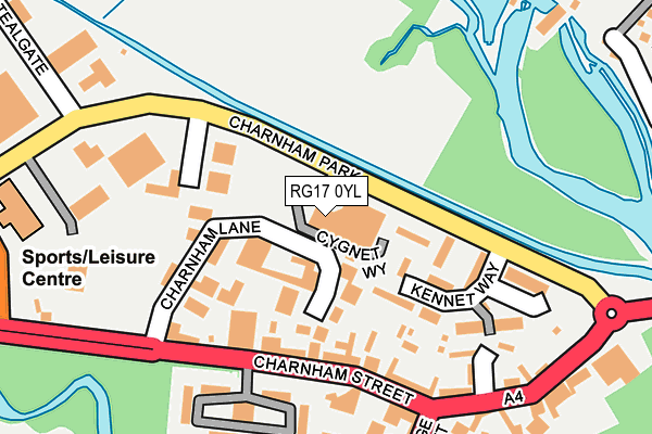
RG17 0YL is located in the Hungerford & Kintbury electoral ward, within the unitary authority of West Berkshire and the English Parliamentary constituency of Newbury. The Sub Integrated Care Board (ICB) Location is NHS Buckinghamshire, Oxfordshire and Berkshire West ICB - 15A and the police force is Thames Valley. This postcode has been in use since June 2001.


GetTheData
Source: OS OpenMap – Local (Ordnance Survey)
Source: OS VectorMap District (Ordnance Survey)
Licence: Open Government Licence (requires attribution)
| Easting | 433863 |
| Northing | 169084 |
| Latitude | 51.419764 |
| Longitude | -1.514407 |
GetTheData
Source: Open Postcode Geo
Licence: Open Government Licence
| Country | England |
| Postcode District | RG17 |
| ➜ RG17 open data dashboard ➜ See where RG17 is on a map ➜ Where is Hungerford? | |
GetTheData
Source: Land Registry Price Paid Data
Licence: Open Government Licence
Elevation or altitude of RG17 0YL as distance above sea level:
| Metres | Feet | |
|---|---|---|
| Elevation | 100m | 328ft |
Elevation is measured from the approximate centre of the postcode, to the nearest point on an OS contour line from OS Terrain 50, which has contour spacing of ten vertical metres.
➜ How high above sea level am I? Find the elevation of your current position using your device's GPS.
GetTheData
Source: Open Postcode Elevation
Licence: Open Government Licence
| Ward | Hungerford & Kintbury |
| Constituency | Newbury |
GetTheData
Source: ONS Postcode Database
Licence: Open Government Licence
| June 2022 | Violence and sexual offences | On or near Chapel Court | 205m |
| June 2022 | Other theft | On or near Chapel Court | 205m |
| June 2022 | Public order | On or near Bridge Street | 264m |
| ➜ Get more crime data in our Crime section | |||
GetTheData
Source: data.police.uk
Licence: Open Government Licence
| Charnham Lane (A4 Charnham Street) | Hungerford | 133m |
| Charnham Lane (A4 Charnham Street) | Hungerford | 148m |
| Canal Bridge (Bridge Street) | Hungerford | 282m |
| Charnham Park (B4192) | Hungerford | 317m |
| Charnham Park (B4192) | Hungerford | 388m |
| Hungerford Station | 0.6km |
| Kintbury Station | 5.1km |
GetTheData
Source: NaPTAN
Licence: Open Government Licence
GetTheData
Source: ONS Postcode Database
Licence: Open Government Licence


➜ Get more ratings from the Food Standards Agency
GetTheData
Source: Food Standards Agency
Licence: FSA terms & conditions
| Last Collection | |||
|---|---|---|---|
| Location | Mon-Fri | Sat | Distance |
| Charnham Street | 17:30 | 08:30 | 144m |
| Hungerford Post Office | 17:30 | 12:15 | 413m |
| High Street | 17:45 | 11:00 | 413m |
GetTheData
Source: Dracos
Licence: Creative Commons Attribution-ShareAlike
| Facility | Distance |
|---|---|
| Herongate Leisure Herongate, Hungerford Health and Fitness Gym, Swimming Pool, Studio, Squash Courts | 282m |
| Hungerford Tennis Club The Croft, Hungerford Outdoor Tennis Courts | 460m |
| Hungerford Primary School Playing Fields Fairview Road, Hungerford Swimming Pool, Grass Pitches | 1km |
GetTheData
Source: Active Places
Licence: Open Government Licence
| School | Phase of Education | Distance |
|---|---|---|
| Hungerford Nursery School Centre for Children 22 The Croft, Hungerford, RG17 0HY | Nursery | 532m |
| Hungerford Primary School Fairview Road, Hungerford, RG17 0BT | Primary | 947m |
| John O'Gaunt School Priory Road, Hungerford, RG17 0AN | Secondary | 1.6km |
GetTheData
Source: Edubase
Licence: Open Government Licence
The below table lists the International Territorial Level (ITL) codes (formerly Nomenclature of Territorial Units for Statistics (NUTS) codes) and Local Administrative Units (LAU) codes for RG17 0YL:
| ITL 1 Code | Name |
|---|---|
| TLJ | South East (England) |
| ITL 2 Code | Name |
| TLJ1 | Berkshire, Buckinghamshire and Oxfordshire |
| ITL 3 Code | Name |
| TLJ11 | Berkshire |
| LAU 1 Code | Name |
| E06000037 | West Berkshire |
GetTheData
Source: ONS Postcode Directory
Licence: Open Government Licence
The below table lists the Census Output Area (OA), Lower Layer Super Output Area (LSOA), and Middle Layer Super Output Area (MSOA) for RG17 0YL:
| Code | Name | |
|---|---|---|
| OA | E00082329 | |
| LSOA | E01016298 | West Berkshire 010C |
| MSOA | E02003376 | West Berkshire 010 |
GetTheData
Source: ONS Postcode Directory
Licence: Open Government Licence
| RG17 0EY | Charnham Lane | 71m |
| RG17 0EJ | Charnham Street | 128m |
| RG17 0YZ | Kennet Way | 142m |
| RG17 0YY | Meadowview | 167m |
| RG17 0DS | Charnham Lane | 175m |
| RG17 0NN | Bearwater | 198m |
| RG17 0HW | Chapel Court | 201m |
| RG17 0ES | Charnham Street | 239m |
| RG17 0ER | Faulknor Square | 252m |
| RG17 0EP | Charnham Street | 260m |
GetTheData
Source: Open Postcode Geo; Land Registry Price Paid Data
Licence: Open Government Licence