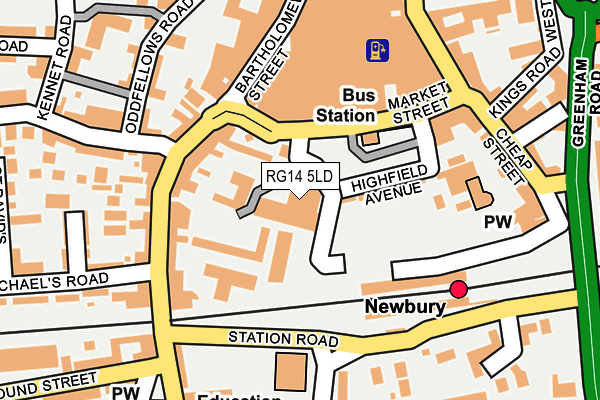
RG14 5LD is located in the Newbury Central electoral ward, within the unitary authority of West Berkshire and the English Parliamentary constituency of Newbury. The Sub Integrated Care Board (ICB) Location is NHS Buckinghamshire, Oxfordshire and Berkshire West ICB - 15A and the police force is Thames Valley. This postcode has been in use since March 1988.


GetTheData
Source: OS OpenMap – Local (Ordnance Survey)
Source: OS VectorMap District (Ordnance Survey)
Licence: Open Government Licence (requires attribution)
| Easting | 447076 |
| Northing | 166809 |
| Latitude | 51.398369 |
| Longitude | -1.324705 |
GetTheData
Source: Open Postcode Geo
Licence: Open Government Licence
| Country | England |
| Postcode District | RG14 |
| ➜ RG14 open data dashboard ➜ See where RG14 is on a map ➜ Where is Newbury? | |
GetTheData
Source: Land Registry Price Paid Data
Licence: Open Government Licence
Elevation or altitude of RG14 5LD as distance above sea level:
| Metres | Feet | |
|---|---|---|
| Elevation | 80m | 262ft |
Elevation is measured from the approximate centre of the postcode, to the nearest point on an OS contour line from OS Terrain 50, which has contour spacing of ten vertical metres.
➜ How high above sea level am I? Find the elevation of your current position using your device's GPS.
GetTheData
Source: Open Postcode Elevation
Licence: Open Government Licence
| Ward | Newbury Central |
| Constituency | Newbury |
GetTheData
Source: ONS Postcode Database
Licence: Open Government Licence
| January 2024 | Violence and sexual offences | On or near Cheap Street | 206m |
| January 2024 | Violence and sexual offences | On or near Cheap Street | 206m |
| December 2023 | Anti-social behaviour | On or near Parking Area | 133m |
| ➜ Get more crime data in our Crime section | |||
GetTheData
Source: data.police.uk
Licence: Open Government Licence
| Newbury Station (Station Road) | Newbury | 167m |
| Newbury Post Office (Cheap Street) | Newbury | 201m |
| Newbury Station (Station Road) | Newbury | 224m |
| Newbury Post Office (Cheap Street) | Newbury | 225m |
| Fair Close (Newtown Road) | Newbury | 245m |
| Newbury Station | 0.2km |
| Newbury Racecourse Station | 1.2km |
GetTheData
Source: NaPTAN
Licence: Open Government Licence
GetTheData
Source: ONS Postcode Database
Licence: Open Government Licence


➜ Get more ratings from the Food Standards Agency
GetTheData
Source: Food Standards Agency
Licence: FSA terms & conditions
| Last Collection | |||
|---|---|---|---|
| Location | Mon-Fri | Sat | Distance |
| Bartholmew Street | 17:30 | 12:00 | 145m |
| Rail Station North | 17:30 | 12:15 | 186m |
| Newbury Delivery Office | 18:30 | 12:45 | 230m |
GetTheData
Source: Dracos
Licence: Creative Commons Attribution-ShareAlike
| Facility | Distance |
|---|---|
| Waterside Centre (Berkshire Youth) Waldegrave Place, Northbrook Street, Newbury Sports Hall, Studio | 455m |
| Anytime Fitness (Newbury) Parkway Shopping Centre, Newbury Health and Fitness Gym, Studio | 517m |
| Flex Muscle & Fitness Gym (Closed) Park Way, Newbury Health and Fitness Gym | 580m |
GetTheData
Source: Active Places
Licence: Open Government Licence
| School | Phase of Education | Distance |
|---|---|---|
| St Nicolas C.E. Junior School Link Road, Newbury, RG14 7LU | Primary | 164m |
| iCollege Alternative Provision 88 Newtown Road, Newbury, RG14 7BT | Not applicable | 540m |
| Victoria Park Nursery School & Family Hub Victoria Park, Parkway, Newbury, RG14 1EH | Nursery | 768m |
GetTheData
Source: Edubase
Licence: Open Government Licence
The below table lists the International Territorial Level (ITL) codes (formerly Nomenclature of Territorial Units for Statistics (NUTS) codes) and Local Administrative Units (LAU) codes for RG14 5LD:
| ITL 1 Code | Name |
|---|---|
| TLJ | South East (England) |
| ITL 2 Code | Name |
| TLJ1 | Berkshire, Buckinghamshire and Oxfordshire |
| ITL 3 Code | Name |
| TLJ11 | Berkshire |
| LAU 1 Code | Name |
| E06000037 | West Berkshire |
GetTheData
Source: ONS Postcode Directory
Licence: Open Government Licence
The below table lists the Census Output Area (OA), Lower Layer Super Output Area (LSOA), and Middle Layer Super Output Area (MSOA) for RG14 5LD:
| Code | Name | |
|---|---|---|
| OA | E00082573 | |
| LSOA | E01016347 | West Berkshire 019C |
| MSOA | E02003385 | West Berkshire 019 |
GetTheData
Source: ONS Postcode Directory
Licence: Open Government Licence
| RG14 5LF | Market Street | 65m |
| RG14 5HF | Bartholomew Street | 93m |
| RG14 5DT | Bartholomew Street | 116m |
| RG14 5DY | Bartholomew Street | 130m |
| RG14 5EE | Bartholomew Street | 157m |
| RG14 5LL | Bartholomew Street | 163m |
| RG14 5QA | Bartholomew Street | 165m |
| RG14 5AE | Craven Road | 175m |
| RG14 5AQ | Oddfellows Road | 177m |
| RG14 5QH | Bartholomew Street | 189m |
GetTheData
Source: Open Postcode Geo; Land Registry Price Paid Data
Licence: Open Government Licence