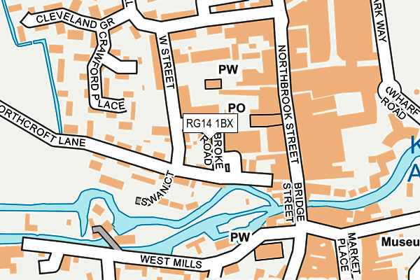
RG14 1BX lies on Pembroke Road in Newbury. RG14 1BX is located in the Newbury Central electoral ward, within the unitary authority of West Berkshire and the English Parliamentary constituency of Newbury. The Sub Integrated Care Board (ICB) Location is NHS Buckinghamshire, Oxfordshire and Berkshire West ICB - 15A and the police force is Thames Valley. This postcode has been in use since July 1995.


GetTheData
Source: OS OpenMap – Local (Ordnance Survey)
Source: OS VectorMap District (Ordnance Survey)
Licence: Open Government Licence (requires attribution)
| Easting | 446978 |
| Northing | 167259 |
| Latitude | 51.402422 |
| Longitude | -1.326035 |
GetTheData
Source: Open Postcode Geo
Licence: Open Government Licence
| Street | Pembroke Road |
| Town/City | Newbury |
| Country | England |
| Postcode District | RG14 |
➜ See where RG14 is on a map ➜ Where is Newbury? | |
GetTheData
Source: Land Registry Price Paid Data
Licence: Open Government Licence
Elevation or altitude of RG14 1BX as distance above sea level:
| Metres | Feet | |
|---|---|---|
| Elevation | 80m | 262ft |
Elevation is measured from the approximate centre of the postcode, to the nearest point on an OS contour line from OS Terrain 50, which has contour spacing of ten vertical metres.
➜ How high above sea level am I? Find the elevation of your current position using your device's GPS.
GetTheData
Source: Open Postcode Elevation
Licence: Open Government Licence
| Ward | Newbury Central |
| Constituency | Newbury |
GetTheData
Source: ONS Postcode Database
Licence: Open Government Licence
| Park Way | Newbury | 287m |
| Park Way | Newbury | 292m |
| Newbury Post Office (Cheap Street) | Newbury | 341m |
| Newbury Post Office (Cheap Street) | Newbury | 365m |
| Kennet Road (Craven Road) | Newbury | 393m |
| Newbury Station | 0.6km |
| Newbury Racecourse Station | 1.3km |
GetTheData
Source: NaPTAN
Licence: Open Government Licence
| Percentage of properties with Next Generation Access | 0.0% |
| Percentage of properties with Superfast Broadband | 0.0% |
| Percentage of properties with Ultrafast Broadband | 0.0% |
| Percentage of properties with Full Fibre Broadband | 0.0% |
Superfast Broadband is between 30Mbps and 300Mbps
Ultrafast Broadband is > 300Mbps
| Percentage of properties unable to receive 2Mbps | 0.0% |
| Percentage of properties unable to receive 5Mbps | 0.0% |
| Percentage of properties unable to receive 10Mbps | 0.0% |
| Percentage of properties unable to receive 30Mbps | 100.0% |
GetTheData
Source: Ofcom
Licence: Ofcom Terms of Use (requires attribution)
Estimated total energy consumption in RG14 1BX by fuel type, 2015.
| Consumption (kWh) | 315,371 |
|---|---|
| Meter count | 26 |
| Mean (kWh/meter) | 12,130 |
| Median (kWh/meter) | 8,079 |
| Consumption (kWh) | 45,582 |
|---|---|
| Meter count | 18 |
| Mean (kWh/meter) | 2,532 |
| Median (kWh/meter) | 2,295 |
GetTheData
Source: Postcode level gas estimates: 2015 (experimental)
Source: Postcode level electricity estimates: 2015 (experimental)
Licence: Open Government Licence
GetTheData
Source: ONS Postcode Database
Licence: Open Government Licence


➜ Get more ratings from the Food Standards Agency
GetTheData
Source: Food Standards Agency
Licence: FSA terms & conditions
| Last Collection | |||
|---|---|---|---|
| Location | Mon-Fri | Sat | Distance |
| Northbrook Street | 17:30 | 11:00 | 134m |
| Mansion House | 17:30 | 11:00 | 190m |
| The Maltings | 17:30 | 12:00 | 288m |
GetTheData
Source: Dracos
Licence: Creative Commons Attribution-ShareAlike
| Risk of RG14 1BX flooding from rivers and sea | Low |
| ➜ RG14 1BX flood map | |
GetTheData
Source: Open Flood Risk by Postcode
Licence: Open Government Licence
The below table lists the International Territorial Level (ITL) codes (formerly Nomenclature of Territorial Units for Statistics (NUTS) codes) and Local Administrative Units (LAU) codes for RG14 1BX:
| ITL 1 Code | Name |
|---|---|
| TLJ | South East (England) |
| ITL 2 Code | Name |
| TLJ1 | Berkshire, Buckinghamshire and Oxfordshire |
| ITL 3 Code | Name |
| TLJ11 | Berkshire |
| LAU 1 Code | Name |
| E06000037 | West Berkshire |
GetTheData
Source: ONS Postcode Directory
Licence: Open Government Licence
The below table lists the Census Output Area (OA), Lower Layer Super Output Area (LSOA), and Middle Layer Super Output Area (MSOA) for RG14 1BX:
| Code | Name | |
|---|---|---|
| OA | E00082572 | |
| LSOA | E01016347 | West Berkshire 019C |
| MSOA | E02003385 | West Berkshire 019 |
GetTheData
Source: ONS Postcode Directory
Licence: Open Government Licence
| RG14 1BE | West Street | 41m |
| RG14 1BU | Northcroft Lane | 54m |
| RG14 1BT | Northcroft Lane | 61m |
| RG14 1JZ | Swan Court | 81m |
| RG14 1AF | Cromwell Place | 88m |
| RG14 1JY | Northcroft Lane | 96m |
| RG14 1BP | Northcroft Lane | 99m |
| RG14 1BS | Northcroft Terrace | 106m |
| RG14 1AA | Northbrook Street | 112m |
| RG14 1BF | West Street | 120m |
GetTheData
Source: Open Postcode Geo; Land Registry Price Paid Data
Licence: Open Government Licence