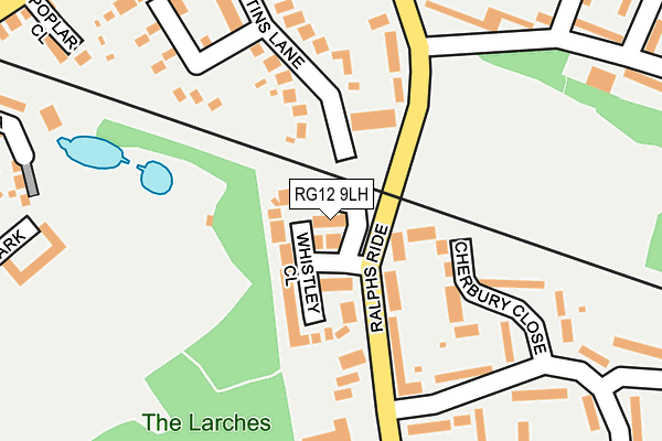
RG12 9LH is located in the Harmans Water & Crown Wood electoral ward, within the unitary authority of Bracknell Forest and the English Parliamentary constituency of Bracknell. The Sub Integrated Care Board (ICB) Location is NHS Frimley ICB - D4U1Y and the police force is Thames Valley. This postcode has been in use since July 1995.


GetTheData
Source: OS OpenMap – Local (Ordnance Survey)
Source: OS VectorMap District (Ordnance Survey)
Licence: Open Government Licence (requires attribution)
| Easting | 488154 |
| Northing | 168558 |
| Latitude | 51.409204 |
| Longitude | -0.733923 |
GetTheData
Source: Open Postcode Geo
Licence: Open Government Licence
| Country | England |
| Postcode District | RG12 |
| ➜ RG12 open data dashboard ➜ See where RG12 is on a map ➜ Where is Bracknell? | |
GetTheData
Source: Land Registry Price Paid Data
Licence: Open Government Licence
Elevation or altitude of RG12 9LH as distance above sea level:
| Metres | Feet | |
|---|---|---|
| Elevation | 70m | 230ft |
Elevation is measured from the approximate centre of the postcode, to the nearest point on an OS contour line from OS Terrain 50, which has contour spacing of ten vertical metres.
➜ How high above sea level am I? Find the elevation of your current position using your device's GPS.
GetTheData
Source: Open Postcode Elevation
Licence: Open Government Licence
| Ward | Harmans Water & Crown Wood |
| Constituency | Bracknell |
GetTheData
Source: ONS Postcode Database
Licence: Open Government Licence
| November 2023 | Violence and sexual offences | On or near Uffington Drive | 402m |
| October 2023 | Violence and sexual offences | On or near Poplar Close | 314m |
| October 2023 | Other crime | On or near Uffington Drive | 402m |
| ➜ Get more crime data in our Crime section | |||
GetTheData
Source: data.police.uk
Licence: Open Government Licence
| Whistley Close (Ralphs Ride) | Bracknell | 67m |
| Whistley Close (Ralphs Ride) | Bracknell | 71m |
| Calfridus Way (Ralphs Ride) | Bracknell | 198m |
| Calfridus Way (Ralphs Ride) | Bracknell | 226m |
| Sycamore Rise (Broad Lane) | Bracknell | 339m |
| Martins Heron Station | 0.7km |
| Bracknell Station | 1.3km |
| Ascot Station | 4.1km |
GetTheData
Source: NaPTAN
Licence: Open Government Licence
GetTheData
Source: ONS Postcode Database
Licence: Open Government Licence


➜ Get more ratings from the Food Standards Agency
GetTheData
Source: Food Standards Agency
Licence: FSA terms & conditions
| Last Collection | |||
|---|---|---|---|
| Location | Mon-Fri | Sat | Distance |
| Harmanswater Post Office | 17:15 | 12:00 | 365m |
| London Road | 16:00 | 11:45 | 568m |
| Beedon Drive | 16:00 | 12:00 | 697m |
GetTheData
Source: Dracos
Licence: Creative Commons Attribution-ShareAlike
| Facility | Distance |
|---|---|
| Calfridus Way Calfridus Way, Bracknell Grass Pitches | 193m |
| Lily Hill Park Lilyhill Drive, Bracknell Grass Pitches, Health and Fitness Gym | 569m |
| Harmans Water Primary School Wellington Drive, Bracknell Artificial Grass Pitch | 580m |
GetTheData
Source: Active Places
Licence: Open Government Licence
| School | Phase of Education | Distance |
|---|---|---|
| Harmans Water Primary School Wellington Drive, Harmans Water, Bracknell, RG12 9NE | Primary | 596m |
| St Joseph's Catholic Primary School, Bracknell Gipsy Lane, Bracknell Forest, RG12 9AP | Primary | 741m |
| Holly Spring Primary School Lily Hill Road, Bracknell, RG12 2SW | Primary | 746m |
GetTheData
Source: Edubase
Licence: Open Government Licence
The below table lists the International Territorial Level (ITL) codes (formerly Nomenclature of Territorial Units for Statistics (NUTS) codes) and Local Administrative Units (LAU) codes for RG12 9LH:
| ITL 1 Code | Name |
|---|---|
| TLJ | South East (England) |
| ITL 2 Code | Name |
| TLJ1 | Berkshire, Buckinghamshire and Oxfordshire |
| ITL 3 Code | Name |
| TLJ11 | Berkshire |
| LAU 1 Code | Name |
| E06000036 | Bracknell Forest |
GetTheData
Source: ONS Postcode Directory
Licence: Open Government Licence
The below table lists the Census Output Area (OA), Lower Layer Super Output Area (LSOA), and Middle Layer Super Output Area (MSOA) for RG12 9LH:
| Code | Name | |
|---|---|---|
| OA | E00081981 | |
| LSOA | E01016224 | Bracknell Forest 006D |
| MSOA | E02003357 | Bracknell Forest 006 |
GetTheData
Source: ONS Postcode Directory
Licence: Open Government Licence
| RG12 9LQ | Whistley Close | 59m |
| RG12 9JQ | Cherbury Close | 79m |
| RG12 9HT | Cherbury Close | 117m |
| RG12 9LN | Ralphs Ride | 139m |
| RG12 9EL | Ralphs Ride | 139m |
| RG12 9LG | Ralphs Ride | 142m |
| RG12 9EF | Northampton Close | 182m |
| RG12 9LE | Ralphs Ride | 200m |
| RG12 9EN | Martins Lane | 213m |
| RG12 9EP | Calfridus Way | 232m |
GetTheData
Source: Open Postcode Geo; Land Registry Price Paid Data
Licence: Open Government Licence