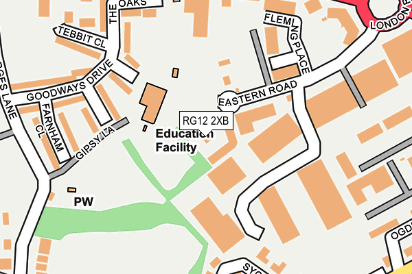
RG12 2XB is located in the Bullbrook electoral ward, within the unitary authority of Bracknell Forest and the English Parliamentary constituency of Bracknell. The Sub Integrated Care Board (ICB) Location is NHS Frimley ICB - D4U1Y and the police force is Thames Valley. This postcode has been in use since February 2003.


GetTheData
Source: OS OpenMap – Local (Ordnance Survey)
Source: OS VectorMap District (Ordnance Survey)
Licence: Open Government Licence (requires attribution)
| Easting | 487769 |
| Northing | 169070 |
| Latitude | 51.413867 |
| Longitude | -0.739313 |
GetTheData
Source: Open Postcode Geo
Licence: Open Government Licence
| Country | England |
| Postcode District | RG12 |
| ➜ RG12 open data dashboard ➜ See where RG12 is on a map ➜ Where is Bracknell? | |
GetTheData
Source: Land Registry Price Paid Data
Licence: Open Government Licence
Elevation or altitude of RG12 2XB as distance above sea level:
| Metres | Feet | |
|---|---|---|
| Elevation | 70m | 230ft |
Elevation is measured from the approximate centre of the postcode, to the nearest point on an OS contour line from OS Terrain 50, which has contour spacing of ten vertical metres.
➜ How high above sea level am I? Find the elevation of your current position using your device's GPS.
GetTheData
Source: Open Postcode Elevation
Licence: Open Government Licence
| Ward | Bullbrook |
| Constituency | Bracknell |
GetTheData
Source: ONS Postcode Database
Licence: Open Government Licence
| December 2023 | Anti-social behaviour | On or near New Road | 346m |
| November 2023 | Drugs | On or near New Road | 346m |
| November 2023 | Drugs | On or near Parking Area | 443m |
| ➜ Get more crime data in our Crime section | |||
GetTheData
Source: data.police.uk
Licence: Open Government Licence
| Bay Road (London Road) | Bracknell | 228m |
| Bay Road (London Road) | Bracknell | 263m |
| Sycamore Rise (Broad Lane) | Bracknell | 304m |
| Deepfield Road West (Deepfield Road) | Bullbrook | 349m |
| Deepfield Road West (Deepfield Road) | Bullbrook | 372m |
| Bracknell Station | 0.9km |
| Martins Heron Station | 1.3km |
| Ascot Station | 4.5km |
GetTheData
Source: NaPTAN
Licence: Open Government Licence
GetTheData
Source: ONS Postcode Database
Licence: Open Government Licence


➜ Get more ratings from the Food Standards Agency
GetTheData
Source: Food Standards Agency
Licence: FSA terms & conditions
| Last Collection | |||
|---|---|---|---|
| Location | Mon-Fri | Sat | Distance |
| Beedon Drive | 16:00 | 12:00 | 496m |
| High Street P.o. Meter Box | 615m | ||
| High Street Post Office | 18:30 | 12:15 | 617m |
GetTheData
Source: Dracos
Licence: Creative Commons Attribution-ShareAlike
| Facility | Distance |
|---|---|
| St Joseph Rc Primary School Gipsy Lane, Bracknell Grass Pitches | 108m |
| Ranelagh School (Larges Lane Pitches) (Closed) Larges Lane, Bracknell Grass Pitches, Athletics | 239m |
| The Sb Group Academy Base Larges Lane, Bracknell Grass Pitches, Artificial Grass Pitch | 378m |
GetTheData
Source: Active Places
Licence: Open Government Licence
| School | Phase of Education | Distance |
|---|---|---|
| St Joseph's Catholic Primary School, Bracknell Gipsy Lane, Bracknell Forest, RG12 9AP | Primary | 107m |
| Holly Spring Primary School Lily Hill Road, Bracknell, RG12 2SW | Primary | 497m |
| Ranelagh School Ranelagh Drive, Bracknell, RG12 9DA | Secondary | 562m |
GetTheData
Source: Edubase
Licence: Open Government Licence
The below table lists the International Territorial Level (ITL) codes (formerly Nomenclature of Territorial Units for Statistics (NUTS) codes) and Local Administrative Units (LAU) codes for RG12 2XB:
| ITL 1 Code | Name |
|---|---|
| TLJ | South East (England) |
| ITL 2 Code | Name |
| TLJ1 | Berkshire, Buckinghamshire and Oxfordshire |
| ITL 3 Code | Name |
| TLJ11 | Berkshire |
| LAU 1 Code | Name |
| E06000036 | Bracknell Forest |
GetTheData
Source: ONS Postcode Directory
Licence: Open Government Licence
The below table lists the Census Output Area (OA), Lower Layer Super Output Area (LSOA), and Middle Layer Super Output Area (MSOA) for RG12 2XB:
| Code | Name | |
|---|---|---|
| OA | E00166645 | |
| LSOA | E01032724 | Bracknell Forest 006F |
| MSOA | E02003357 | Bracknell Forest 006 |
GetTheData
Source: ONS Postcode Directory
Licence: Open Government Licence
| RG12 9AY | Drayton Close | 164m |
| RG12 9AZ | Kenton Close | 167m |
| RG12 2AA | London Road | 190m |
| RG12 2XH | London Road | 202m |
| RG12 9GF | Sycamore Rise | 218m |
| RG12 2XG | The Oaks | 223m |
| RG12 9BA | Tebbit Close | 238m |
| RG12 9GH | Sycamore Rise | 244m |
| RG12 9AU | Goodways Drive | 245m |
| RG12 9BU | Sycamore Rise | 248m |
GetTheData
Source: Open Postcode Geo; Land Registry Price Paid Data
Licence: Open Government Licence