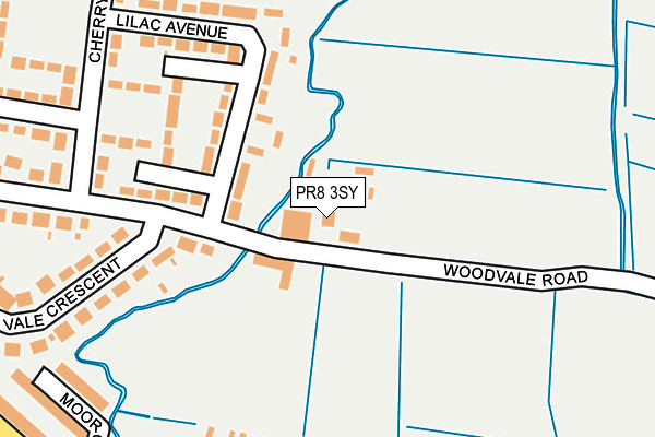
PR8 3SY is located in the Rural West electoral ward, within the local authority district of West Lancashire and the English Parliamentary constituency of West Lancashire. The Sub Integrated Care Board (ICB) Location is NHS Lancashire and South Cumbria ICB - 02G and the police force is Lancashire. This postcode has been in use since January 1980.


GetTheData
Source: OS OpenMap – Local (Ordnance Survey)
Source: OS VectorMap District (Ordnance Survey)
Licence: Open Government Licence (requires attribution)
| Easting | 331750 |
| Northing | 410691 |
| Latitude | 53.588355 |
| Longitude | -3.032507 |
GetTheData
Source: Open Postcode Geo
Licence: Open Government Licence
| Country | England |
| Postcode District | PR8 |
| ➜ PR8 open data dashboard ➜ See where PR8 is on a map ➜ Where is Southport? | |
GetTheData
Source: Land Registry Price Paid Data
Licence: Open Government Licence
Elevation or altitude of PR8 3SY as distance above sea level:
| Metres | Feet | |
|---|---|---|
| Elevation | 10m | 33ft |
Elevation is measured from the approximate centre of the postcode, to the nearest point on an OS contour line from OS Terrain 50, which has contour spacing of ten vertical metres.
➜ How high above sea level am I? Find the elevation of your current position using your device's GPS.
GetTheData
Source: Open Postcode Elevation
Licence: Open Government Licence
| Ward | Rural West |
| Constituency | West Lancashire |
GetTheData
Source: ONS Postcode Database
Licence: Open Government Licence
| December 2023 | Criminal damage and arson | On or near Kings Meadow | 408m |
| November 2023 | Public order | On or near Kings Meadow | 408m |
| April 2023 | Anti-social behaviour | On or near Kings Meadow | 408m |
| ➜ Get more crime data in our Crime section | |||
GetTheData
Source: data.police.uk
Licence: Open Government Licence
| Lilac Avenue (Cherry Road) | Ainsdale | 292m |
| Rose Crescent (Cherry Road) | Ainsdale | 322m |
| Vale Crescent (Woodvale Road) | Ainsdale | 421m |
| Cherry Road (Meadow Lane) | Ainsdale | 437m |
| Liverpool Road (Woodvale Road) | Ainsdale | 473m |
| Ainsdale Station | 1.7km |
| Freshfield Station | 3.6km |
| Hillside Station | 3.8km |
GetTheData
Source: NaPTAN
Licence: Open Government Licence
| Percentage of properties with Next Generation Access | 100.0% |
| Percentage of properties with Superfast Broadband | 100.0% |
| Percentage of properties with Ultrafast Broadband | 0.0% |
| Percentage of properties with Full Fibre Broadband | 0.0% |
Superfast Broadband is between 30Mbps and 300Mbps
Ultrafast Broadband is > 300Mbps
| Percentage of properties unable to receive 2Mbps | 0.0% |
| Percentage of properties unable to receive 5Mbps | 0.0% |
| Percentage of properties unable to receive 10Mbps | 0.0% |
| Percentage of properties unable to receive 30Mbps | 0.0% |
GetTheData
Source: Ofcom
Licence: Ofcom Terms of Use (requires attribution)
GetTheData
Source: ONS Postcode Database
Licence: Open Government Licence


➜ Get more ratings from the Food Standards Agency
GetTheData
Source: Food Standards Agency
Licence: FSA terms & conditions
| Last Collection | |||
|---|---|---|---|
| Location | Mon-Fri | Sat | Distance |
| 50 Cherry Road, Ainsdale | 16:15 | 11:00 | 278m |
| Woodvale Road, Ainsdale | 17:30 | 11:00 | 494m |
| Woodvale | 17:30 | 11:30 | 593m |
GetTheData
Source: Dracos
Licence: Creative Commons Attribution-ShareAlike
| Facility | Distance |
|---|---|
| Kings Meadow Primary School Meadow Lane, Southport Grass Pitches | 415m |
| Sandbrook Road Recreation Ground Sandbrook Road, Southport Grass Pitches | 713m |
| Formby Hall Golf Resort And Spa Southport Old Road, Formby, Liverpool Golf, Health and Fitness Gym, Swimming Pool | 976m |
GetTheData
Source: Active Places
Licence: Open Government Licence
| School | Phase of Education | Distance |
|---|---|---|
| Kings Meadow Primary School and Early Years Education Centre Meadow Lane, Ainsdale, Southport, PR8 3RS | Primary | 445m |
| Ainsdale St John's Church of England Primary School Sandbrook Road, Ainsdale, Southport, PR8 3JE | Primary | 1.3km |
| Merefield School Westminster Drive, Southport, PR8 2QZ | Not applicable | 1.5km |
GetTheData
Source: Edubase
Licence: Open Government Licence
The below table lists the International Territorial Level (ITL) codes (formerly Nomenclature of Territorial Units for Statistics (NUTS) codes) and Local Administrative Units (LAU) codes for PR8 3SY:
| ITL 1 Code | Name |
|---|---|
| TLD | North West (England) |
| ITL 2 Code | Name |
| TLD4 | Lancashire |
| ITL 3 Code | Name |
| TLD47 | Chorley and West Lancashire |
| LAU 1 Code | Name |
| E07000127 | West Lancashire |
GetTheData
Source: ONS Postcode Directory
Licence: Open Government Licence
The below table lists the Census Output Area (OA), Lower Layer Super Output Area (LSOA), and Middle Layer Super Output Area (MSOA) for PR8 3SY:
| Code | Name | |
|---|---|---|
| OA | E00129382 | |
| LSOA | E01025495 | West Lancashire 003B |
| MSOA | E02005306 | West Lancashire 003 |
GetTheData
Source: ONS Postcode Directory
Licence: Open Government Licence
| PR8 3SX | Woodvale Road | 150m |
| PR8 3RY | Lilac Avenue | 152m |
| PR8 3SF | Cherry Road | 218m |
| PR8 3RX | Heather Close | 282m |
| PR8 3SZ | Vale Crescent | 292m |
| PR8 3PA | Moor Close | 302m |
| PR8 3SU | Woodvale Road | 346m |
| PR8 3SE | Cherry Road | 353m |
| PR8 3NY | Moor Lane | 362m |
| PR8 3RU | Cherry Road | 375m |
GetTheData
Source: Open Postcode Geo; Land Registry Price Paid Data
Licence: Open Government Licence