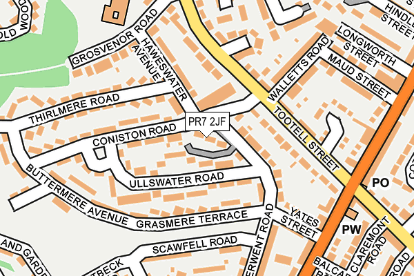
PR7 2JF is located in the Chorley South West electoral ward, within the local authority district of Chorley and the English Parliamentary constituency of Chorley. The Sub Integrated Care Board (ICB) Location is NHS Lancashire and South Cumbria ICB - 00X and the police force is Lancashire. This postcode has been in use since January 1980.


GetTheData
Source: OS OpenMap – Local (Ordnance Survey)
Source: OS VectorMap District (Ordnance Survey)
Licence: Open Government Licence (requires attribution)
| Easting | 357748 |
| Northing | 416598 |
| Latitude | 53.644191 |
| Longitude | -2.640600 |
GetTheData
Source: Open Postcode Geo
Licence: Open Government Licence
| Country | England |
| Postcode District | PR7 |
| ➜ PR7 open data dashboard ➜ See where PR7 is on a map ➜ Where is Chorley? | |
GetTheData
Source: Land Registry Price Paid Data
Licence: Open Government Licence
Elevation or altitude of PR7 2JF as distance above sea level:
| Metres | Feet | |
|---|---|---|
| Elevation | 80m | 262ft |
Elevation is measured from the approximate centre of the postcode, to the nearest point on an OS contour line from OS Terrain 50, which has contour spacing of ten vertical metres.
➜ How high above sea level am I? Find the elevation of your current position using your device's GPS.
GetTheData
Source: Open Postcode Elevation
Licence: Open Government Licence
| Ward | Chorley South West |
| Constituency | Chorley |
GetTheData
Source: ONS Postcode Database
Licence: Open Government Licence
| January 2024 | Criminal damage and arson | On or near Lakeland Gardens | 393m |
| January 2024 | Other crime | On or near Lakeland Gardens | 393m |
| January 2024 | Other theft | On or near Lakeland Gardens | 393m |
| ➜ Get more crime data in our Crime section | |||
GetTheData
Source: data.police.uk
Licence: Open Government Licence
| Coniston House (Tootell Street) | Collingwood Road | 97m |
| Coniston House (Collingwood Road) | Collingwood Road | 140m |
| Weldbank Lane (Moor Road) | Collingwood Road | 220m |
| Weldbank Lane (Pall Mall) | Collingwood Road | 225m |
| Gloucester Road (Weldbank Lane) | Weldbank | 297m |
| Chorley Station | 1.3km |
| Euxton Balshaw Lane Station | 2.8km |
| Buckshaw Parkway Station | 3.5km |
GetTheData
Source: NaPTAN
Licence: Open Government Licence
| Percentage of properties with Next Generation Access | 100.0% |
| Percentage of properties with Superfast Broadband | 100.0% |
| Percentage of properties with Ultrafast Broadband | 100.0% |
| Percentage of properties with Full Fibre Broadband | 0.0% |
Superfast Broadband is between 30Mbps and 300Mbps
Ultrafast Broadband is > 300Mbps
| Percentage of properties unable to receive 2Mbps | 0.0% |
| Percentage of properties unable to receive 5Mbps | 0.0% |
| Percentage of properties unable to receive 10Mbps | 0.0% |
| Percentage of properties unable to receive 30Mbps | 0.0% |
GetTheData
Source: Ofcom
Licence: Ofcom Terms of Use (requires attribution)
GetTheData
Source: ONS Postcode Database
Licence: Open Government Licence


➜ Get more ratings from the Food Standards Agency
GetTheData
Source: Food Standards Agency
Licence: FSA terms & conditions
| Last Collection | |||
|---|---|---|---|
| Location | Mon-Fri | Sat | Distance |
| Richmond House | 17:00 | 11:30 | 473m |
| Hornchurch Drive | 17:30 | 11:30 | 778m |
| Cloverfield, Clayton Le Woods | 17:15 | 10:45 | 1,059m |
GetTheData
Source: Dracos
Licence: Creative Commons Attribution-ShareAlike
| Facility | Distance |
|---|---|
| Buttermere Green Buttermere Avenue, Chorley Grass Pitches | 236m |
| Gillibrand Playing Pitches Ennerdale Road, Chorley Grass Pitches | 348m |
| Chorley All Saints C Of E Primary School Moor Road, Chorley Grass Pitches | 371m |
GetTheData
Source: Active Places
Licence: Open Government Licence
| School | Phase of Education | Distance |
|---|---|---|
| Gillibrand Primary School Grosvenor Road, Chorley, PR7 2PJ | Primary | 242m |
| Chorley All Saints Church of England Primary School and Nursery Unit Moor Road, Chorley, PR7 2LR | Primary | 369m |
| Westmorland School Weldbank Lane, Chorley, PR7 3NQ | Not applicable | 404m |
GetTheData
Source: Edubase
Licence: Open Government Licence
The below table lists the International Territorial Level (ITL) codes (formerly Nomenclature of Territorial Units for Statistics (NUTS) codes) and Local Administrative Units (LAU) codes for PR7 2JF:
| ITL 1 Code | Name |
|---|---|
| TLD | North West (England) |
| ITL 2 Code | Name |
| TLD4 | Lancashire |
| ITL 3 Code | Name |
| TLD47 | Chorley and West Lancashire |
| LAU 1 Code | Name |
| E07000118 | Chorley |
GetTheData
Source: ONS Postcode Directory
Licence: Open Government Licence
The below table lists the Census Output Area (OA), Lower Layer Super Output Area (LSOA), and Middle Layer Super Output Area (MSOA) for PR7 2JF:
| Code | Name | |
|---|---|---|
| OA | E00126604 | |
| LSOA | E01024945 | Chorley 012D |
| MSOA | E02005200 | Chorley 012 |
GetTheData
Source: ONS Postcode Directory
Licence: Open Government Licence
| PR7 2JE | Derwent Road | 81m |
| PR7 2JB | Ullswater Road | 96m |
| PR7 2HZ | Tootell Street | 107m |
| PR7 2JD | Haweswater Avenue | 109m |
| PR7 2JJ | Grasmere Terrace | 109m |
| PR7 2HX | Tootell Street | 117m |
| PR7 2PH | Pembroke Place | 137m |
| PR7 2JA | Coniston Road | 145m |
| PR7 2JS | Yates Street | 152m |
| PR7 2HY | Black Horse Street | 165m |
GetTheData
Source: Open Postcode Geo; Land Registry Price Paid Data
Licence: Open Government Licence