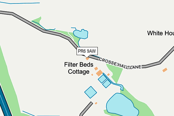
PR6 9AW lies on Crosse Hall Lane in Chorley. PR6 9AW is located in the Chorley East electoral ward, within the local authority district of Chorley and the English Parliamentary constituency of Chorley. The Sub Integrated Care Board (ICB) Location is NHS Lancashire and South Cumbria ICB - 00X and the police force is Lancashire. This postcode has been in use since January 1980.


GetTheData
Source: OS OpenMap – Local (Ordnance Survey)
Source: OS VectorMap District (Ordnance Survey)
Licence: Open Government Licence (requires attribution)
| Easting | 360200 |
| Northing | 417387 |
| Latitude | 53.651458 |
| Longitude | -2.603616 |
GetTheData
Source: Open Postcode Geo
Licence: Open Government Licence
| Street | Crosse Hall Lane |
| Town/City | Chorley |
| Country | England |
| Postcode District | PR6 |
➜ See where PR6 is on a map | |
GetTheData
Source: Land Registry Price Paid Data
Licence: Open Government Licence
Elevation or altitude of PR6 9AW as distance above sea level:
| Metres | Feet | |
|---|---|---|
| Elevation | 130m | 427ft |
Elevation is measured from the approximate centre of the postcode, to the nearest point on an OS contour line from OS Terrain 50, which has contour spacing of ten vertical metres.
➜ How high above sea level am I? Find the elevation of your current position using your device's GPS.
GetTheData
Source: Open Postcode Elevation
Licence: Open Government Licence
| Ward | Chorley East |
| Constituency | Chorley |
GetTheData
Source: ONS Postcode Database
Licence: Open Government Licence
| Fdc Relief (Moorland Gate) | Cowling | 642m |
| Spinners Arms (Cowling Road) | Cowling | 746m |
| Crosse Hall Street (Cowling Brow) | Cowling | 753m |
| Spinners Arms (Cowling Road) | Cowling | 756m |
| St James Bowling Club (Ownes Street) | Eaves Lane | 913m |
| Chorley Station | 1.5km |
| Adlington (Lancs) Station | 4.3km |
| Buckshaw Parkway Station | 4.5km |
GetTheData
Source: NaPTAN
Licence: Open Government Licence
| Percentage of properties with Next Generation Access | 85.7% |
| Percentage of properties with Superfast Broadband | 57.1% |
| Percentage of properties with Ultrafast Broadband | 0.0% |
| Percentage of properties with Full Fibre Broadband | 0.0% |
Superfast Broadband is between 30Mbps and 300Mbps
Ultrafast Broadband is > 300Mbps
| Percentage of properties unable to receive 2Mbps | 0.0% |
| Percentage of properties unable to receive 5Mbps | 0.0% |
| Percentage of properties unable to receive 10Mbps | 14.3% |
| Percentage of properties unable to receive 30Mbps | 28.6% |
GetTheData
Source: Ofcom
Licence: Ofcom Terms of Use (requires attribution)
GetTheData
Source: ONS Postcode Database
Licence: Open Government Licence


➜ Get more ratings from the Food Standards Agency
GetTheData
Source: Food Standards Agency
Licence: FSA terms & conditions
| Last Collection | |||
|---|---|---|---|
| Location | Mon-Fri | Sat | Distance |
| Devonshire Road Post Office | 17:30 | 11:30 | 656m |
| Limbrick | 16:30 | 10:30 | 986m |
| Gillibrand Street | 17:15 | 11:45 | 1,123m |
GetTheData
Source: Dracos
Licence: Creative Commons Attribution-ShareAlike
| Risk of PR6 9AW flooding from rivers and sea | Low |
| ➜ PR6 9AW flood map | |
GetTheData
Source: Open Flood Risk by Postcode
Licence: Open Government Licence
The below table lists the International Territorial Level (ITL) codes (formerly Nomenclature of Territorial Units for Statistics (NUTS) codes) and Local Administrative Units (LAU) codes for PR6 9AW:
| ITL 1 Code | Name |
|---|---|
| TLD | North West (England) |
| ITL 2 Code | Name |
| TLD4 | Lancashire |
| ITL 3 Code | Name |
| TLD47 | Chorley and West Lancashire |
| LAU 1 Code | Name |
| E07000118 | Chorley |
GetTheData
Source: ONS Postcode Directory
Licence: Open Government Licence
The below table lists the Census Output Area (OA), Lower Layer Super Output Area (LSOA), and Middle Layer Super Output Area (MSOA) for PR6 9AW:
| Code | Name | |
|---|---|---|
| OA | E00126525 | |
| LSOA | E01024926 | Chorley 009B |
| MSOA | E02005197 | Chorley 009 |
GetTheData
Source: ONS Postcode Directory
Licence: Open Government Licence
| PR6 9FN | Lightoller Close | 524m |
| PR6 9AN | Crosse Hall Fold | 527m |
| PR6 9AD | Crosse Hall Fold | 536m |
| PR6 9FG | Haworth Road | 610m |
| PR6 9FH | Tate Fold | 663m |
| PR6 9FJ | Ferrier Grove | 672m |
| PR6 9AR | Froom Street | 718m |
| PR6 0UA | The Moorings | 741m |
| PR6 9FL | Darlington Close | 741m |
| PR6 9EA | Cowling Road | 748m |
GetTheData
Source: Open Postcode Geo; Land Registry Price Paid Data
Licence: Open Government Licence