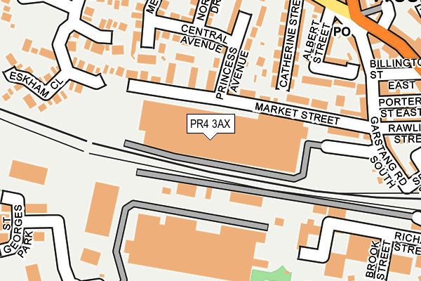
PR4 3AX is located in the Medlar-with-Wesham electoral ward, within the local authority district of Fylde and the English Parliamentary constituency of Fylde. The Sub Integrated Care Board (ICB) Location is NHS Lancashire and South Cumbria ICB - 02M and the police force is Lancashire. This postcode has been in use since January 1980.


GetTheData
Source: OS OpenMap – Local (Ordnance Survey)
Source: OS VectorMap District (Ordnance Survey)
Licence: Open Government Licence (requires attribution)
| Easting | 341537 |
| Northing | 432747 |
| Latitude | 53.787742 |
| Longitude | -2.888847 |
GetTheData
Source: Open Postcode Geo
Licence: Open Government Licence
| Country | England |
| Postcode District | PR4 |
➜ See where PR4 is on a map ➜ Where is Wesham? | |
GetTheData
Source: Land Registry Price Paid Data
Licence: Open Government Licence
Elevation or altitude of PR4 3AX as distance above sea level:
| Metres | Feet | |
|---|---|---|
| Elevation | 20m | 66ft |
Elevation is measured from the approximate centre of the postcode, to the nearest point on an OS contour line from OS Terrain 50, which has contour spacing of ten vertical metres.
➜ How high above sea level am I? Find the elevation of your current position using your device's GPS.
GetTheData
Source: Open Postcode Elevation
Licence: Open Government Licence
| Ward | Medlar-with-wesham |
| Constituency | Fylde |
GetTheData
Source: ONS Postcode Database
Licence: Open Government Licence
| Everest Court (Market Street) | Wesham | 177m |
| Wyre Street (Station Road) | Wesham | 286m |
| Lane Ends Pub (Weeton Road) | Wesham | 291m |
| Lane Ends Pub (Weeton Road) | Wesham | 293m |
| Wyre Street (Station Road) | Wesham | 298m |
| Kirkham & Wesham Station | 0.4km |
| Moss Side Station | 4.4km |
| Salwick Station | 4.8km |
GetTheData
Source: NaPTAN
Licence: Open Government Licence
GetTheData
Source: ONS Postcode Database
Licence: Open Government Licence


➜ Get more ratings from the Food Standards Agency
GetTheData
Source: Food Standards Agency
Licence: FSA terms & conditions
| Last Collection | |||
|---|---|---|---|
| Location | Mon-Fri | Sat | Distance |
| Wesham Post Office | 17:00 | 09:45 | 260m |
| Wesham Cross | 17:00 | 09:45 | 546m |
| Sunnybank | 17:30 | 09:45 | 630m |
GetTheData
Source: Dracos
Licence: Creative Commons Attribution-ShareAlike
| Risk of PR4 3AX flooding from rivers and sea | Low |
| ➜ PR4 3AX flood map | |
GetTheData
Source: Open Flood Risk by Postcode
Licence: Open Government Licence
The below table lists the International Territorial Level (ITL) codes (formerly Nomenclature of Territorial Units for Statistics (NUTS) codes) and Local Administrative Units (LAU) codes for PR4 3AX:
| ITL 1 Code | Name |
|---|---|
| TLD | North West (England) |
| ITL 2 Code | Name |
| TLD4 | Lancashire |
| ITL 3 Code | Name |
| TLD45 | Mid Lancashire |
| LAU 1 Code | Name |
| E07000119 | Fylde |
GetTheData
Source: ONS Postcode Directory
Licence: Open Government Licence
The below table lists the Census Output Area (OA), Lower Layer Super Output Area (LSOA), and Middle Layer Super Output Area (MSOA) for PR4 3AX:
| Code | Name | |
|---|---|---|
| OA | E00126959 | |
| LSOA | E01025013 | Fylde 002F |
| MSOA | E02005204 | Fylde 002 |
GetTheData
Source: ONS Postcode Directory
Licence: Open Government Licence
| PR4 3AY | Market Street | 88m |
| PR4 3BB | Meadow Crescent | 114m |
| PR4 3DL | Central Avenue | 148m |
| PR4 3BA | Princess Avenue | 158m |
| PR4 3BP | Catherine Street | 188m |
| PR4 3EQ | Knightsbridge Close | 191m |
| PR4 3BD | Everest Court | 191m |
| PR4 3BE | Billington Street | 200m |
| PR4 3EE | Fallowfield Close | 206m |
| PR4 3DJ | North Drive | 207m |
GetTheData
Source: Open Postcode Geo; Land Registry Price Paid Data
Licence: Open Government Licence