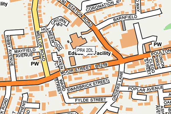
PR4 2DL is located in the Kirkham electoral ward, within the local authority district of Fylde and the English Parliamentary constituency of Fylde. The Sub Integrated Care Board (ICB) Location is NHS Lancashire and South Cumbria ICB - 02M and the police force is Lancashire. This postcode has been in use since January 1980.


GetTheData
Source: OS OpenMap – Local (Ordnance Survey)
Source: OS VectorMap District (Ordnance Survey)
Licence: Open Government Licence (requires attribution)
| Easting | 342208 |
| Northing | 432093 |
| Latitude | 53.781939 |
| Longitude | -2.878541 |
GetTheData
Source: Open Postcode Geo
Licence: Open Government Licence
| Country | England |
| Postcode District | PR4 |
| ➜ PR4 open data dashboard ➜ See where PR4 is on a map ➜ Where is Kirkham? | |
GetTheData
Source: Land Registry Price Paid Data
Licence: Open Government Licence
Elevation or altitude of PR4 2DL as distance above sea level:
| Metres | Feet | |
|---|---|---|
| Elevation | 20m | 66ft |
Elevation is measured from the approximate centre of the postcode, to the nearest point on an OS contour line from OS Terrain 50, which has contour spacing of ten vertical metres.
➜ How high above sea level am I? Find the elevation of your current position using your device's GPS.
GetTheData
Source: Open Postcode Elevation
Licence: Open Government Licence
| Ward | Kirkham |
| Constituency | Fylde |
GetTheData
Source: ONS Postcode Database
Licence: Open Government Licence
| January 2024 | Violence and sexual offences | On or near Swarbrick Street | 104m |
| January 2024 | Vehicle crime | On or near Parking Area | 155m |
| January 2024 | Other crime | On or near Parking Area | 155m |
| ➜ Get more crime data in our Crime section | |||
GetTheData
Source: data.police.uk
Licence: Open Government Licence
| Moor Street | Kirkham | 112m |
| Swan Hotel (Poulton Street) | Kirkham | 186m |
| Morrisons (Poulton Street) | Kirkham | 230m |
| Library (Station Road) | Kirkham | 260m |
| Library (Station Road) | Kirkham | 320m |
| Kirkham & Wesham Station | 0.6km |
| Salwick Station | 4.1km |
| Moss Side Station | 4.6km |
GetTheData
Source: NaPTAN
Licence: Open Government Licence
GetTheData
Source: ONS Postcode Database
Licence: Open Government Licence


➜ Get more ratings from the Food Standards Agency
GetTheData
Source: Food Standards Agency
Licence: FSA terms & conditions
| Last Collection | |||
|---|---|---|---|
| Location | Mon-Fri | Sat | Distance |
| Town End | 17:30 | 09:45 | 141m |
| Sunnybank | 17:30 | 09:45 | 314m |
| Kirkgate, Kirkham | 17:30 | 10:00 | 403m |
GetTheData
Source: Dracos
Licence: Creative Commons Attribution-ShareAlike
| Facility | Distance |
|---|---|
| Rural Splash Ymca Kirkham (Closed) Station Road, Kirkham, Preston Swimming Pool, Health and Fitness Gym | 130m |
| Maryfields Barnfield, Kirkham Grass Pitches | 297m |
| William Segar Hodgson Playing Fields Coronation Road, Kirkham Grass Pitches | 312m |
GetTheData
Source: Active Places
Licence: Open Government Licence
| School | Phase of Education | Distance |
|---|---|---|
| Kirkham Pear Tree School 29 Station Road, Kirkham, Preston, PR4 2HA | Not applicable | 72m |
| Kirkham and Wesham Primary School Nelson Street, Kirkham, Preston, PR4 2JP | Primary | 362m |
| The Willows Catholic Primary School, Kirkham Victoria Road, Kirkham, Preston, PR4 2BT | Primary | 363m |
GetTheData
Source: Edubase
Licence: Open Government Licence
The below table lists the International Territorial Level (ITL) codes (formerly Nomenclature of Territorial Units for Statistics (NUTS) codes) and Local Administrative Units (LAU) codes for PR4 2DL:
| ITL 1 Code | Name |
|---|---|
| TLD | North West (England) |
| ITL 2 Code | Name |
| TLD4 | Lancashire |
| ITL 3 Code | Name |
| TLD45 | Mid Lancashire |
| LAU 1 Code | Name |
| E07000119 | Fylde |
GetTheData
Source: ONS Postcode Directory
Licence: Open Government Licence
The below table lists the Census Output Area (OA), Lower Layer Super Output Area (LSOA), and Middle Layer Super Output Area (MSOA) for PR4 2DL:
| Code | Name | |
|---|---|---|
| OA | E00126928 | |
| LSOA | E01025009 | Fylde 002C |
| MSOA | E02005204 | Fylde 002 |
GetTheData
Source: ONS Postcode Directory
Licence: Open Government Licence
| PR4 2AU | Moor Street | 52m |
| PR4 2AS | Station Road | 103m |
| PR4 2HG | Holmeswood | 104m |
| PR4 2DB | Swarbrick Street | 109m |
| PR4 2DD | Fylde Street | 141m |
| PR4 2DA | Ward Street | 151m |
| PR4 2HA | Station Road | 153m |
| PR4 2DE | Fylde Street | 158m |
| PR4 2HW | Crown Mews | 159m |
| PR4 2AQ | Barnfield | 164m |
GetTheData
Source: Open Postcode Geo; Land Registry Price Paid Data
Licence: Open Government Licence