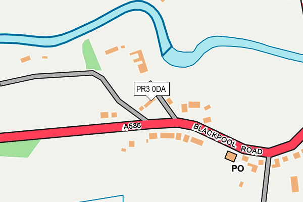
PR3 0DA is located in the Great Eccleston electoral ward, within the local authority district of Wyre and the English Parliamentary constituency of Wyre and Preston North. The Sub Integrated Care Board (ICB) Location is NHS Lancashire and South Cumbria ICB - 02M and the police force is Lancashire. This postcode has been in use since May 2016.


GetTheData
Source: OS OpenMap – Local (Ordnance Survey)
Source: OS VectorMap District (Ordnance Survey)
Licence: Open Government Licence (requires attribution)
| Easting | 345823 |
| Northing | 441007 |
| Latitude | 53.862454 |
| Longitude | -2.825255 |
GetTheData
Source: Open Postcode Geo
Licence: Open Government Licence
| Country | England |
| Postcode District | PR3 |
➜ See where PR3 is on a map ➜ Where is St Michael's on Wyre? | |
GetTheData
Source: Land Registry Price Paid Data
Licence: Open Government Licence
Elevation or altitude of PR3 0DA as distance above sea level:
| Metres | Feet | |
|---|---|---|
| Elevation | 10m | 33ft |
Elevation is measured from the approximate centre of the postcode, to the nearest point on an OS contour line from OS Terrain 50, which has contour spacing of ten vertical metres.
➜ How high above sea level am I? Find the elevation of your current position using your device's GPS.
GetTheData
Source: Open Postcode Elevation
Licence: Open Government Licence
| Ward | Great Eccleston |
| Constituency | Wyre And Preston North |
GetTheData
Source: ONS Postcode Database
Licence: Open Government Licence
| Village Hall (Blackpool Road) | St Michael's On Wyre | 176m |
| Village Hall (Blackpool Road) | St Michael's On Wyre | 178m |
| Primary School (Hall Lane) | St Michael's On Wyre | 353m |
| Primary School (Hall Lane) | St Michael's On Wyre | 363m |
| Grapes Hotel (Garstang Road) | St Michael's On Wyre | 369m |
GetTheData
Source: NaPTAN
Licence: Open Government Licence
| Percentage of properties with Next Generation Access | 100.0% |
| Percentage of properties with Superfast Broadband | 100.0% |
| Percentage of properties with Ultrafast Broadband | 0.0% |
| Percentage of properties with Full Fibre Broadband | 0.0% |
Superfast Broadband is between 30Mbps and 300Mbps
Ultrafast Broadband is > 300Mbps
| Percentage of properties unable to receive 2Mbps | 0.0% |
| Percentage of properties unable to receive 5Mbps | 0.0% |
| Percentage of properties unable to receive 10Mbps | 0.0% |
| Percentage of properties unable to receive 30Mbps | 0.0% |
GetTheData
Source: Ofcom
Licence: Ofcom Terms of Use (requires attribution)
GetTheData
Source: ONS Postcode Database
Licence: Open Government Licence

➜ Get more ratings from the Food Standards Agency
GetTheData
Source: Food Standards Agency
Licence: FSA terms & conditions
| Last Collection | |||
|---|---|---|---|
| Location | Mon-Fri | Sat | Distance |
| Catterall Post Office | 17:00 | 10:30 | 4,191m |
| Joe Lane | 17:00 | 10:30 | 4,522m |
| Windsor Road | 15:30 | 11:00 | 5,211m |
GetTheData
Source: Dracos
Licence: Creative Commons Attribution-ShareAlike
| Risk of PR3 0DA flooding from rivers and sea | Low |
| ➜ PR3 0DA flood map | |
GetTheData
Source: Open Flood Risk by Postcode
Licence: Open Government Licence
The below table lists the International Territorial Level (ITL) codes (formerly Nomenclature of Territorial Units for Statistics (NUTS) codes) and Local Administrative Units (LAU) codes for PR3 0DA:
| ITL 1 Code | Name |
|---|---|
| TLD | North West (England) |
| ITL 2 Code | Name |
| TLD4 | Lancashire |
| ITL 3 Code | Name |
| TLD44 | Lancaster and Wyre |
| LAU 1 Code | Name |
| E07000128 | Wyre |
GetTheData
Source: ONS Postcode Directory
Licence: Open Government Licence
The below table lists the Census Output Area (OA), Lower Layer Super Output Area (LSOA), and Middle Layer Super Output Area (MSOA) for PR3 0DA:
| Code | Name | |
|---|---|---|
| OA | E00129719 | |
| LSOA | E01025562 | Wyre 009B |
| MSOA | E02005327 | Wyre 009 |
GetTheData
Source: ONS Postcode Directory
Licence: Open Government Licence
| PR3 0UA | Blackpool Road | 87m |
| PR3 0UP | Wyre Bank | 94m |
| PR3 0UB | Blackpool Road | 98m |
| PR3 0TN | Paddington Avenue | 349m |
| PR3 0TJ | Garstang Road | 359m |
| PR3 0TP | Ash Grove | 387m |
| PR3 0UD | Rawcliffe Road | 391m |
| PR3 0UE | Rawcliffe Road | 442m |
| PR3 0TE | Garstang Road | 523m |
| PR3 0TZ | Allotment Lane | 537m |
GetTheData
Source: Open Postcode Geo; Land Registry Price Paid Data
Licence: Open Government Licence