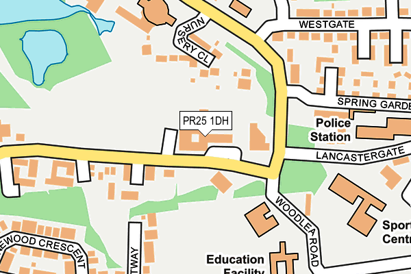
PR25 1DH is located in the Broadfield electoral ward, within the local authority district of South Ribble and the English Parliamentary constituency of South Ribble. The Sub Integrated Care Board (ICB) Location is NHS Lancashire and South Cumbria ICB - 00X and the police force is Lancashire. This postcode has been in use since June 2001.


GetTheData
Source: OS OpenMap – Local (Ordnance Survey)
Source: OS VectorMap District (Ordnance Survey)
Licence: Open Government Licence (requires attribution)
| Easting | 353620 |
| Northing | 421779 |
| Latitude | 53.690404 |
| Longitude | -2.703813 |
GetTheData
Source: Open Postcode Geo
Licence: Open Government Licence
| Country | England |
| Postcode District | PR25 |
| ➜ PR25 open data dashboard ➜ See where PR25 is on a map ➜ Where is Leyland? | |
GetTheData
Source: Land Registry Price Paid Data
Licence: Open Government Licence
Elevation or altitude of PR25 1DH as distance above sea level:
| Metres | Feet | |
|---|---|---|
| Elevation | 30m | 98ft |
Elevation is measured from the approximate centre of the postcode, to the nearest point on an OS contour line from OS Terrain 50, which has contour spacing of ten vertical metres.
➜ How high above sea level am I? Find the elevation of your current position using your device's GPS.
GetTheData
Source: Open Postcode Elevation
Licence: Open Government Licence
| Ward | Broadfield |
| Constituency | South Ribble |
GetTheData
Source: ONS Postcode Database
Licence: Open Government Licence
| January 2024 | Public order | On or near Lancastergate | 258m |
| January 2024 | Anti-social behaviour | On or near Lancastergate | 258m |
| January 2024 | Anti-social behaviour | On or near Lancastergate | 258m |
| ➜ Get more crime data in our Crime section | |||
GetTheData
Source: data.police.uk
Licence: Open Government Licence
| Civic Centre (West Paddock) | Broadfield | 88m |
| South Ribble Borough Council Offices (West Paddock) | Broadfield | 98m |
| Fire Station (Broadfield Drive) | Broadfield | 184m |
| Fire Station (Broadfield Drive) | Broadfield | 192m |
| Leisure Centre (Lancastergate) | Towngate | 193m |
| Leyland Station | 1.4km |
| Buckshaw Parkway Station | 3.4km |
| Lostock Hall Station | 3.9km |
GetTheData
Source: NaPTAN
Licence: Open Government Licence
GetTheData
Source: ONS Postcode Database
Licence: Open Government Licence


➜ Get more ratings from the Food Standards Agency
GetTheData
Source: Food Standards Agency
Licence: FSA terms & conditions
| Last Collection | |||
|---|---|---|---|
| Location | Mon-Fri | Sat | Distance |
| Tesco Stores Limited | 17:00 | 12:00 | 421m |
| Leyland South Post Office | 17:30 | 12:00 | 432m |
| Westfield Drive | 17:15 | 12:00 | 551m |
GetTheData
Source: Dracos
Licence: Creative Commons Attribution-ShareAlike
| Facility | Distance |
|---|---|
| Woodlea Junior School Woodlea Road, Leyland Grass Pitches | 209m |
| Leyland Leisure Centre Lancaster Gate, Leyland Sports Hall, Swimming Pool, Health and Fitness Gym, Squash Courts, Studio | 228m |
| Leyland Fox Lane Sports And Social Club Fox Lane, Leyland Grass Pitches, Outdoor Tennis Courts | 327m |
GetTheData
Source: Active Places
Licence: Open Government Licence
| School | Phase of Education | Distance |
|---|---|---|
| Leyland St Andrew's Church of England Infant School Woodlea Road, Leyland, Preston, PR25 1JL | Primary | 149m |
| Woodlea Junior School Woodlea Road, Leyland, PR25 1JL | Primary | 228m |
| Wellfield Academy Yewlands Drive, Leyland, PR25 2TP | Secondary | 553m |
GetTheData
Source: Edubase
Licence: Open Government Licence
The below table lists the International Territorial Level (ITL) codes (formerly Nomenclature of Territorial Units for Statistics (NUTS) codes) and Local Administrative Units (LAU) codes for PR25 1DH:
| ITL 1 Code | Name |
|---|---|
| TLD | North West (England) |
| ITL 2 Code | Name |
| TLD4 | Lancashire |
| ITL 3 Code | Name |
| TLD45 | Mid Lancashire |
| LAU 1 Code | Name |
| E07000126 | South Ribble |
GetTheData
Source: ONS Postcode Directory
Licence: Open Government Licence
The below table lists the Census Output Area (OA), Lower Layer Super Output Area (LSOA), and Middle Layer Super Output Area (MSOA) for PR25 1DH:
| Code | Name | |
|---|---|---|
| OA | E00129146 | |
| LSOA | E01025446 | South Ribble 015D |
| MSOA | E02005301 | South Ribble 015 |
GetTheData
Source: ONS Postcode Directory
Licence: Open Government Licence
| PR25 1NS | Nursery Close | 116m |
| PR25 1HG | Roberts Court | 128m |
| PR25 1LB | Broadfield Drive | 166m |
| PR25 1LD | Broadfield Drive | 202m |
| PR25 1HL | Forest Way | 214m |
| PR25 1JJ | West Paddock | 228m |
| PR25 2NA | Fairfield Road | 252m |
| PR25 2EQ | Spring Gardens | 259m |
| PR25 2LX | Westgate | 263m |
| PR25 2EX | Lancaster Gate | 263m |
GetTheData
Source: Open Postcode Geo; Land Registry Price Paid Data
Licence: Open Government Licence