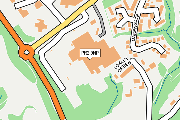
PR2 9NP is located in the Garrison electoral ward, within the local authority district of Preston and the English Parliamentary constituency of Wyre and Preston North. The Sub Integrated Care Board (ICB) Location is NHS Lancashire and South Cumbria ICB - 01E and the police force is Lancashire. This postcode has been in use since December 1996.


GetTheData
Source: OS OpenMap – Local (Ordnance Survey)
Source: OS VectorMap District (Ordnance Survey)
Licence: Open Government Licence (requires attribution)
| Easting | 354978 |
| Northing | 432976 |
| Latitude | 53.791139 |
| Longitude | -2.684888 |
GetTheData
Source: Open Postcode Geo
Licence: Open Government Licence
| Country | England |
| Postcode District | PR2 |
| ➜ PR2 open data dashboard ➜ See where PR2 is on a map ➜ Where is Preston? | |
GetTheData
Source: Land Registry Price Paid Data
Licence: Open Government Licence
Elevation or altitude of PR2 9NP as distance above sea level:
| Metres | Feet | |
|---|---|---|
| Elevation | 50m | 164ft |
Elevation is measured from the approximate centre of the postcode, to the nearest point on an OS contour line from OS Terrain 50, which has contour spacing of ten vertical metres.
➜ How high above sea level am I? Find the elevation of your current position using your device's GPS.
GetTheData
Source: Open Postcode Elevation
Licence: Open Government Licence
| Ward | Garrison |
| Constituency | Wyre And Preston North |
GetTheData
Source: ONS Postcode Database
Licence: Open Government Licence
| June 2022 | Shoplifting | On or near Loxley Green | 117m |
| June 2022 | Violence and sexual offences | On or near Loxley Green | 117m |
| June 2022 | Shoplifting | On or near Loxley Green | 117m |
| ➜ Get more crime data in our Crime section | |||
GetTheData
Source: data.police.uk
Licence: Open Government Licence
| Fulwood Asda (Pittman Way) | Eastway | 90m |
| Fulwood Asda (Pittman Way) | Eastway | 92m |
| Fulwood Asda (Pittman Lane) | Eastway | 93m |
| Williams Lane (Pittman Way) | Eastway | 331m |
| Williams Lane (Pittman Way) | Eastway | 334m |
| Preston Station | 4.1km |
GetTheData
Source: NaPTAN
Licence: Open Government Licence
GetTheData
Source: ONS Postcode Database
Licence: Open Government Licence


➜ Get more ratings from the Food Standards Agency
GetTheData
Source: Food Standards Agency
Licence: FSA terms & conditions
| Last Collection | |||
|---|---|---|---|
| Location | Mon-Fri | Sat | Distance |
| Preston Mail Centre | 19:30 | 12:30 | 578m |
| Sherwood Way | 17:30 | 11:30 | 826m |
| Olivers Place | 876m | ||
GetTheData
Source: Dracos
Licence: Creative Commons Attribution-ShareAlike
| Facility | Distance |
|---|---|
| Preston Golf Club Fulwood Hall Lane, Fulwood, Preston Golf | 745m |
| Gymworks Preston Pittman Way, Fulwood, Preston Health and Fitness Gym | 793m |
| Longsands Lynx Community Jfc Longsands Lane, Fulwood, Preston Grass Pitches | 818m |
GetTheData
Source: Active Places
Licence: Open Government Licence
| School | Phase of Education | Distance |
|---|---|---|
| Sherwood Primary School Sherwood Way, Fulwood, Preston, PR2 9GA | Primary | 761m |
| Longsands Community Primary School Longsands Lane, Fulwood, Preston, PR2 9PS | Primary | 876m |
| St Clare's Catholic Primary School, Preston Sharoe Green Lane North, Fulwood, Preston, PR2 9HH | Primary | 1.1km |
GetTheData
Source: Edubase
Licence: Open Government Licence
The below table lists the International Territorial Level (ITL) codes (formerly Nomenclature of Territorial Units for Statistics (NUTS) codes) and Local Administrative Units (LAU) codes for PR2 9NP:
| ITL 1 Code | Name |
|---|---|
| TLD | North West (England) |
| ITL 2 Code | Name |
| TLD4 | Lancashire |
| ITL 3 Code | Name |
| TLD45 | Mid Lancashire |
| LAU 1 Code | Name |
| E07000123 | Preston |
GetTheData
Source: ONS Postcode Directory
Licence: Open Government Licence
The below table lists the Census Output Area (OA), Lower Layer Super Output Area (LSOA), and Middle Layer Super Output Area (MSOA) for PR2 9NP:
| Code | Name | |
|---|---|---|
| OA | E00172008 | |
| LSOA | E01025253 | Preston 004A |
| MSOA | E02005256 | Preston 004 |
GetTheData
Source: ONS Postcode Directory
Licence: Open Government Licence
| PR2 9UY | Loxley Green | 124m |
| PR2 9AF | Larchgate | 180m |
| PR2 9SX | Midgery Lane | 194m |
| PR2 9AE | Oakengate | 203m |
| PR2 9AG | Rowangate | 253m |
| PR2 9UX | Lady Well Drive | 385m |
| PR2 9WB | Spruce Close | 391m |
| PR2 9UG | Hindley Close | 432m |
| PR2 9NA | Sycamore Close | 464m |
| PR2 9UT | Williams Lane | 470m |
GetTheData
Source: Open Postcode Geo; Land Registry Price Paid Data
Licence: Open Government Licence