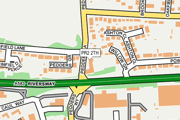
PR2 2TH is located in the Ashton electoral ward, within the local authority district of Preston and the English Parliamentary constituency of Preston. The Sub Integrated Care Board (ICB) Location is NHS Lancashire and South Cumbria ICB - 01E and the police force is Lancashire. This postcode has been in use since August 1992.


GetTheData
Source: OS OpenMap – Local (Ordnance Survey)
Source: OS VectorMap District (Ordnance Survey)
Licence: Open Government Licence (requires attribution)
| Easting | 351297 |
| Northing | 429932 |
| Latitude | 53.763450 |
| Longitude | -2.740277 |
GetTheData
Source: Open Postcode Geo
Licence: Open Government Licence
| Country | England |
| Postcode District | PR2 |
| ➜ PR2 open data dashboard ➜ See where PR2 is on a map ➜ Where is Preston? | |
GetTheData
Source: Land Registry Price Paid Data
Licence: Open Government Licence
Elevation or altitude of PR2 2TH as distance above sea level:
| Metres | Feet | |
|---|---|---|
| Elevation | 10m | 33ft |
Elevation is measured from the approximate centre of the postcode, to the nearest point on an OS contour line from OS Terrain 50, which has contour spacing of ten vertical metres.
➜ How high above sea level am I? Find the elevation of your current position using your device's GPS.
GetTheData
Source: Open Postcode Elevation
Licence: Open Government Licence
| Ward | Ashton |
| Constituency | Preston |
GetTheData
Source: ONS Postcode Database
Licence: Open Government Licence
| June 2022 | Anti-social behaviour | On or near Pedder'S Lane | 101m |
| June 2022 | Anti-social behaviour | On or near Pedder'S Lane | 101m |
| June 2022 | Anti-social behaviour | On or near Pedders Way | 148m |
| ➜ Get more crime data in our Crime section | |||
GetTheData
Source: data.police.uk
Licence: Open Government Licence
| Whinfield Lane (Pedders Lane) | Ashton-on-ribble | 51m |
| Whinfield Lane (Pedders Lane) | Ashton-on-ribble | 101m |
| Mcdonalds (Pedders Way) | Riversway | 154m |
| Powis Road (Watery Lane) | Ashton-on-ribble | 181m |
| Mcdonalds (Pedders Way) | Riversway | 183m |
| Preston Station | 2.2km |
| Lostock Hall Station | 5.6km |
GetTheData
Source: NaPTAN
Licence: Open Government Licence
GetTheData
Source: ONS Postcode Database
Licence: Open Government Licence


➜ Get more ratings from the Food Standards Agency
GetTheData
Source: Food Standards Agency
Licence: FSA terms & conditions
| Last Collection | |||
|---|---|---|---|
| Location | Mon-Fri | Sat | Distance |
| Morrisons | 16:30 | 11:00 | 328m |
| 85 Powis Road, Ashton-on-ribble | 17:00 | 11:30 | 355m |
| Navigation Way, Ashton | 17:30 | 11:30 | 359m |
GetTheData
Source: Dracos
Licence: Creative Commons Attribution-ShareAlike
| Facility | Distance |
|---|---|
| Ashton Park (Preston) Blackpool Road, Ashton-on-ribble, Preston Grass Pitches, Outdoor Tennis Courts | 482m |
| Jd Gyms (Preston) Port Way, Ashton-on-ribble, Preston Swimming Pool, Health and Fitness Gym, Studio | 938m |
| Haslam Park Bristow Avenue, Preston Outdoor Tennis Courts | 1km |
GetTheData
Source: Active Places
Licence: Open Government Licence
| School | Phase of Education | Distance |
|---|---|---|
| Ashton-on-Ribble St Andrew's Church of England Primary School Tulketh Road, Ashton-on-Ribble, Preston, PR2 1EQ | Primary | 616m |
| Spen Brook School (former Hawes Side Library), Hawes Side Lane, Blackpool, FY4 5AJ | Not applicable | 842m |
| The Limes School 73A Taunton Road, Ashton under Lyne, Gtr Manchester, Preston, OL7 9DU | Not applicable | 842m |
GetTheData
Source: Edubase
Licence: Open Government Licence
The below table lists the International Territorial Level (ITL) codes (formerly Nomenclature of Territorial Units for Statistics (NUTS) codes) and Local Administrative Units (LAU) codes for PR2 2TH:
| ITL 1 Code | Name |
|---|---|
| TLD | North West (England) |
| ITL 2 Code | Name |
| TLD4 | Lancashire |
| ITL 3 Code | Name |
| TLD45 | Mid Lancashire |
| LAU 1 Code | Name |
| E07000123 | Preston |
GetTheData
Source: ONS Postcode Directory
Licence: Open Government Licence
The below table lists the Census Output Area (OA), Lower Layer Super Output Area (LSOA), and Middle Layer Super Output Area (MSOA) for PR2 2TH:
| Code | Name | |
|---|---|---|
| OA | E00128073 | |
| LSOA | E01025231 | Preston 013A |
| MSOA | E02005265 | Preston 013 |
GetTheData
Source: ONS Postcode Directory
Licence: Open Government Licence
| PR2 1AG | Willow Green | 73m |
| PR2 1AN | Pedders Lane | 97m |
| PR2 1NS | Pedders Grove | 104m |
| PR2 1AH | Ashton Close | 121m |
| PR2 1AL | Egerton Road | 225m |
| PR2 1AE | Powis Road | 253m |
| PR2 1AP | Brooklands | 268m |
| PR2 1NR | Whinfield Place | 275m |
| PR2 1HL | Pedders Lane | 277m |
| PR2 1BL | Oakfield | 321m |
GetTheData
Source: Open Postcode Geo; Land Registry Price Paid Data
Licence: Open Government Licence