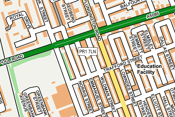
PR1 7LN is located in the Plungington electoral ward, within the local authority district of Preston and the English Parliamentary constituency of Preston. The Sub Integrated Care Board (ICB) Location is NHS Lancashire and South Cumbria ICB - 01E and the police force is Lancashire. This postcode has been in use since June 1981.


GetTheData
Source: OS OpenMap – Local (Ordnance Survey)
Source: OS VectorMap District (Ordnance Survey)
Licence: Open Government Licence (requires attribution)
| Easting | 353034 |
| Northing | 430960 |
| Latitude | 53.772848 |
| Longitude | -2.714087 |
GetTheData
Source: Open Postcode Geo
Licence: Open Government Licence
| Country | England |
| Postcode District | PR1 |
| ➜ PR1 open data dashboard ➜ See where PR1 is on a map ➜ Where is Preston? | |
GetTheData
Source: Land Registry Price Paid Data
Licence: Open Government Licence
Elevation or altitude of PR1 7LN as distance above sea level:
| Metres | Feet | |
|---|---|---|
| Elevation | 30m | 98ft |
Elevation is measured from the approximate centre of the postcode, to the nearest point on an OS contour line from OS Terrain 50, which has contour spacing of ten vertical metres.
➜ How high above sea level am I? Find the elevation of your current position using your device's GPS.
GetTheData
Source: Open Postcode Elevation
Licence: Open Government Licence
| Ward | Plungington |
| Constituency | Preston |
GetTheData
Source: ONS Postcode Database
Licence: Open Government Licence
| January 2024 | Anti-social behaviour | On or near Supermarket | 311m |
| January 2024 | Anti-social behaviour | On or near Supermarket | 311m |
| January 2024 | Anti-social behaviour | On or near Supermarket | 311m |
| ➜ Get more crime data in our Crime section | |||
GetTheData
Source: data.police.uk
Licence: Open Government Licence
| West End Motors (Blackpool Road) | Plungington | 68m |
| Trafford Street (Plungington Road) | Plungington | 91m |
| Trafford Street (Plungington Road) | Plungington | 95m |
| Plungington Road (Blackpool Road) | Plungington | 128m |
| Linton Street (Plungington Road) | Fulwood | 151m |
| Preston Station | 1.8km |
GetTheData
Source: NaPTAN
Licence: Open Government Licence
GetTheData
Source: ONS Postcode Database
Licence: Open Government Licence


➜ Get more ratings from the Food Standards Agency
GetTheData
Source: Food Standards Agency
Licence: FSA terms & conditions
| Last Collection | |||
|---|---|---|---|
| Location | Mon-Fri | Sat | Distance |
| Cattle Market Post Office | 17:30 | 11:15 | 161m |
| 131 Waterloo Road, Ashton | 17:00 | 11:30 | 306m |
| Plungington Road North | 17:30 | 11:30 | 470m |
GetTheData
Source: Dracos
Licence: Creative Commons Attribution-ShareAlike
| Facility | Distance |
|---|---|
| Ultra Flex Gym Shelley Road, Ashton-on-ribble, Preston Health and Fitness Gym | 773m |
| Mill Lane Playing Fields (Fulwood) Mill Lane, Fulwood, Preston Grass Pitches | 891m |
| Fulwood Lawn Tennis Club Watling Street Road, Fulwood, Preston Outdoor Tennis Courts | 920m |
GetTheData
Source: Active Places
Licence: Open Government Licence
| School | Phase of Education | Distance |
|---|---|---|
| Eldon Primary School Eldon Street, Preston, PR1 7YE | Primary | 269m |
| Moorbrook School Ainslie Road, Fulwood, Preston, PR2 3DB | Not applicable | 294m |
| The Roebuck School Inkerman Street, Ashton, Preston, PR2 2BN | Primary | 481m |
GetTheData
Source: Edubase
Licence: Open Government Licence
The below table lists the International Territorial Level (ITL) codes (formerly Nomenclature of Territorial Units for Statistics (NUTS) codes) and Local Administrative Units (LAU) codes for PR1 7LN:
| ITL 1 Code | Name |
|---|---|
| TLD | North West (England) |
| ITL 2 Code | Name |
| TLD4 | Lancashire |
| ITL 3 Code | Name |
| TLD45 | Mid Lancashire |
| LAU 1 Code | Name |
| E07000123 | Preston |
GetTheData
Source: ONS Postcode Directory
Licence: Open Government Licence
The below table lists the Census Output Area (OA), Lower Layer Super Output Area (LSOA), and Middle Layer Super Output Area (MSOA) for PR1 7LN:
| Code | Name | |
|---|---|---|
| OA | E00128476 | |
| LSOA | E01025308 | Preston 012B |
| MSOA | E02005264 | Preston 012 |
GetTheData
Source: ONS Postcode Directory
Licence: Open Government Licence
| PR1 7NS | Emmanuel Street | 27m |
| PR1 7QL | Wildman Street | 36m |
| PR1 7UB | Plungington Road | 49m |
| PR1 7QD | Trafford Street | 61m |
| PR1 7QA | Norris Street | 66m |
| PR1 7QE | Trafford Street | 71m |
| PR1 7XU | Lowndes Street | 85m |
| PR2 3AB | Blackpool Road | 95m |
| PR2 3BJ | Linton Street | 117m |
| PR2 3ED | Linton Street | 120m |
GetTheData
Source: Open Postcode Geo; Land Registry Price Paid Data
Licence: Open Government Licence