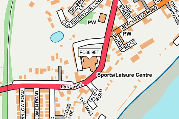
PO36 9ET is located in the Sandown South electoral ward, within the unitary authority of Isle of Wight and the English Parliamentary constituency of Isle of Wight. The Sub Integrated Care Board (ICB) Location is NHS Hampshire and Isle of Wight ICB - D9Y0V and the police force is Hampshire. This postcode has been in use since March 1983.


GetTheData
Source: OS OpenMap – Local (Ordnance Survey)
Source: OS VectorMap District (Ordnance Survey)
Licence: Open Government Licence (requires attribution)
| Easting | 459350 |
| Northing | 83821 |
| Latitude | 50.651056 |
| Longitude | -1.161854 |
GetTheData
Source: Open Postcode Geo
Licence: Open Government Licence
| Country | England |
| Postcode District | PO36 |
| ➜ PO36 open data dashboard ➜ See where PO36 is on a map ➜ Where is Sandown? | |
GetTheData
Source: Land Registry Price Paid Data
Licence: Open Government Licence
Elevation or altitude of PO36 9ET as distance above sea level:
| Metres | Feet | |
|---|---|---|
| Elevation | 40m | 131ft |
Elevation is measured from the approximate centre of the postcode, to the nearest point on an OS contour line from OS Terrain 50, which has contour spacing of ten vertical metres.
➜ How high above sea level am I? Find the elevation of your current position using your device's GPS.
GetTheData
Source: Open Postcode Elevation
Licence: Open Government Licence
| Ward | Sandown South |
| Constituency | Isle Of Wight |
GetTheData
Source: ONS Postcode Database
Licence: Open Government Licence
| June 2022 | Anti-social behaviour | On or near Grange Road | 135m |
| June 2022 | Other theft | On or near Drabbles Lane | 206m |
| June 2022 | Violence and sexual offences | On or near Royal Street | 382m |
| ➜ Get more crime data in our Crime section | |||
GetTheData
Source: data.police.uk
Licence: Open Government Licence
| The Heights (Lake Hill) | Sandown | 54m |
| The Heights (Lake Hill) | Sandown | 60m |
| New Street (Beachfield Road) | Sandown | 187m |
| Health Centre (The Fairway) | Lake | 331m |
| The Fairway (Lake Hill) | Lake | 351m |
| Lake (Isle of Wight) Station | 0.6km |
| Sandown Station | 0.6km |
| Shanklin Station | 2.3km |
GetTheData
Source: NaPTAN
Licence: Open Government Licence
| Percentage of properties with Next Generation Access | 100.0% |
| Percentage of properties with Superfast Broadband | 100.0% |
| Percentage of properties with Ultrafast Broadband | 0.0% |
| Percentage of properties with Full Fibre Broadband | 0.0% |
Superfast Broadband is between 30Mbps and 300Mbps
Ultrafast Broadband is > 300Mbps
| Percentage of properties unable to receive 2Mbps | 0.0% |
| Percentage of properties unable to receive 5Mbps | 0.0% |
| Percentage of properties unable to receive 10Mbps | 0.0% |
| Percentage of properties unable to receive 30Mbps | 0.0% |
GetTheData
Source: Ofcom
Licence: Ofcom Terms of Use (requires attribution)
GetTheData
Source: ONS Postcode Database
Licence: Open Government Licence


➜ Get more ratings from the Food Standards Agency
GetTheData
Source: Food Standards Agency
Licence: FSA terms & conditions
| Last Collection | |||
|---|---|---|---|
| Location | Mon-Fri | Sat | Distance |
| Leisure Centre | 16:45 | 11:00 | 69m |
| Ranelagh Road | 17:00 | 11:00 | 289m |
| Fairway | 16:45 | 11:30 | 333m |
GetTheData
Source: Dracos
Licence: Creative Commons Attribution-ShareAlike
| Facility | Distance |
|---|---|
| The Heights Leisure Centre Broadway, Sandown Swimming Pool, Health and Fitness Gym, Studio, Squash Courts | 0m |
| Fairway Park (Sandown And Lake Youth Fc) The Fairway, Sandown Grass Pitches | 446m |
| Sandown & Shanklin Rfc (Fairway Ground) Station Approach, Sandown Grass Pitches | 616m |
GetTheData
Source: Active Places
Licence: Open Government Licence
| School | Phase of Education | Distance |
|---|---|---|
| The Bay Church of England School Winchester Park Road, Isle of Wight, Sandown, PO36 9BA | All-through | 719m |
| Broadlea Primary School Newport Road, Lake, Sandown, PO36 9PE | Primary | 1km |
| OEA Education 1 Faulkner Lane, Sandown, PO36 9AZ | Not applicable | 1.5km |
GetTheData
Source: Edubase
Licence: Open Government Licence
The below table lists the International Territorial Level (ITL) codes (formerly Nomenclature of Territorial Units for Statistics (NUTS) codes) and Local Administrative Units (LAU) codes for PO36 9ET:
| ITL 1 Code | Name |
|---|---|
| TLJ | South East (England) |
| ITL 2 Code | Name |
| TLJ3 | Hampshire and Isle of Wight |
| ITL 3 Code | Name |
| TLJ34 | Isle of Wight |
| LAU 1 Code | Name |
| E06000046 | Isle of Wight |
GetTheData
Source: ONS Postcode Directory
Licence: Open Government Licence
The below table lists the Census Output Area (OA), Lower Layer Super Output Area (LSOA), and Middle Layer Super Output Area (MSOA) for PO36 9ET:
| Code | Name | |
|---|---|---|
| OA | E00087627 | |
| LSOA | E01017349 | Isle of Wight 014D |
| MSOA | E02003594 | Isle of Wight 014 |
GetTheData
Source: ONS Postcode Directory
Licence: Open Government Licence
| PO36 9EB | Broadway | 71m |
| PO36 9FD | Broadway | 84m |
| PO36 8NF | Beachfield Road | 99m |
| PO36 8NP | Talbot Road | 107m |
| PO36 9EX | Lake Hill | 113m |
| PO36 9ED | The Mall | 141m |
| PO36 8NE | Grange Road | 142m |
| PO36 9HA | Lake Hill | 153m |
| PO36 9DL | Old Reservoir Lane | 171m |
| PO36 8NL | Sunnyside Gardens | 171m |
GetTheData
Source: Open Postcode Geo; Land Registry Price Paid Data
Licence: Open Government Licence