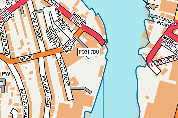
PO31 7DU is located in the Cowes Medina electoral ward, within the unitary authority of Isle of Wight and the English Parliamentary constituency of Isle of Wight. The Sub Integrated Care Board (ICB) Location is NHS Hampshire and Isle of Wight ICB - D9Y0V and the police force is Hampshire. This postcode has been in use since February 1984.


GetTheData
Source: OS OpenMap – Local (Ordnance Survey)
Source: OS VectorMap District (Ordnance Survey)
Licence: Open Government Licence (requires attribution)
| Easting | 449928 |
| Northing | 95641 |
| Latitude | 50.758213 |
| Longitude | -1.293513 |
GetTheData
Source: Open Postcode Geo
Licence: Open Government Licence
| Country | England |
| Postcode District | PO31 |
➜ See where PO31 is on a map ➜ Where is Cowes? | |
GetTheData
Source: Land Registry Price Paid Data
Licence: Open Government Licence
Elevation or altitude of PO31 7DU as distance above sea level:
| Metres | Feet | |
|---|---|---|
| Elevation | 10m | 33ft |
Elevation is measured from the approximate centre of the postcode, to the nearest point on an OS contour line from OS Terrain 50, which has contour spacing of ten vertical metres.
➜ How high above sea level am I? Find the elevation of your current position using your device's GPS.
GetTheData
Source: Open Postcode Elevation
Licence: Open Government Licence
| Ward | Cowes Medina |
| Constituency | Isle Of Wight |
GetTheData
Source: ONS Postcode Database
Licence: Open Government Licence
| Red Funnel Terminal (Dover Road) | East Cowes | 287m |
| Arctic Road (Newport Road) | Cowes | 313m |
| Birmingham Road | Cowes | 313m |
| Arctic Road (Newport Road) | Cowes | 315m |
| Well Road | East Cowes | 366m |
GetTheData
Source: NaPTAN
Licence: Open Government Licence
GetTheData
Source: ONS Postcode Database
Licence: Open Government Licence


➜ Get more ratings from the Food Standards Agency
GetTheData
Source: Food Standards Agency
Licence: FSA terms & conditions
| Last Collection | |||
|---|---|---|---|
| Location | Mon-Fri | Sat | Distance |
| Medina Road | 17:00 | 11:45 | 24m |
| Arctic Road | 17:15 | 12:00 | 355m |
| Well Road Post Office | 17:30 | 11:45 | 403m |
GetTheData
Source: Dracos
Licence: Creative Commons Attribution-ShareAlike
| Risk of PO31 7DU flooding from rivers and sea | High |
| ➜ PO31 7DU flood map | |
GetTheData
Source: Open Flood Risk by Postcode
Licence: Open Government Licence
The below table lists the International Territorial Level (ITL) codes (formerly Nomenclature of Territorial Units for Statistics (NUTS) codes) and Local Administrative Units (LAU) codes for PO31 7DU:
| ITL 1 Code | Name |
|---|---|
| TLJ | South East (England) |
| ITL 2 Code | Name |
| TLJ3 | Hampshire and Isle of Wight |
| ITL 3 Code | Name |
| TLJ34 | Isle of Wight |
| LAU 1 Code | Name |
| E06000046 | Isle of Wight |
GetTheData
Source: ONS Postcode Directory
Licence: Open Government Licence
The below table lists the Census Output Area (OA), Lower Layer Super Output Area (LSOA), and Middle Layer Super Output Area (MSOA) for PO31 7DU:
| Code | Name | |
|---|---|---|
| OA | E00087397 | |
| LSOA | E01017305 | Isle of Wight 001C |
| MSOA | E02003581 | Isle of Wight 001 |
GetTheData
Source: ONS Postcode Directory
Licence: Open Government Licence
| PO31 7DD | Brunswick Road | 39m |
| PO31 7BX | Medina Road | 77m |
| PO31 7DF | St Andrews Street | 88m |
| PO31 7XF | Medina Road | 90m |
| PO31 7DH | Bridge Road | 102m |
| PO31 7XB | Medina Road | 118m |
| PO31 7RJ | St Andrews Street | 133m |
| PO31 7BS | York Street | 146m |
| PO31 7DJ | Thetis Road | 159m |
| PO31 7DS | Pelham Road | 179m |
GetTheData
Source: Open Postcode Geo; Land Registry Price Paid Data
Licence: Open Government Licence