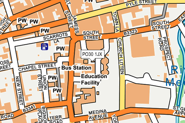
PO30 1JX is located in the Newport Central electoral ward, within the unitary authority of Isle of Wight and the English Parliamentary constituency of Isle of Wight. The Sub Integrated Care Board (ICB) Location is NHS Hampshire and Isle of Wight ICB - D9Y0V and the police force is Hampshire. This postcode has been in use since January 1980.


GetTheData
Source: OS OpenMap – Local (Ordnance Survey)
Source: OS VectorMap District (Ordnance Survey)
Licence: Open Government Licence (requires attribution)
| Easting | 449925 |
| Northing | 88938 |
| Latitude | 50.697940 |
| Longitude | -1.294461 |
GetTheData
Source: Open Postcode Geo
Licence: Open Government Licence
| Country | England |
| Postcode District | PO30 |
| ➜ PO30 open data dashboard ➜ See where PO30 is on a map ➜ Where is Newport? | |
GetTheData
Source: Land Registry Price Paid Data
Licence: Open Government Licence
Elevation or altitude of PO30 1JX as distance above sea level:
| Metres | Feet | |
|---|---|---|
| Elevation | 10m | 33ft |
Elevation is measured from the approximate centre of the postcode, to the nearest point on an OS contour line from OS Terrain 50, which has contour spacing of ten vertical metres.
➜ How high above sea level am I? Find the elevation of your current position using your device's GPS.
GetTheData
Source: Open Postcode Elevation
Licence: Open Government Licence
| Ward | Newport Central |
| Constituency | Isle Of Wight |
GetTheData
Source: ONS Postcode Database
Licence: Open Government Licence
| January 2024 | Violence and sexual offences | On or near Bignor Place | 220m |
| January 2024 | Theft from the person | On or near Parking Area | 270m |
| January 2024 | Robbery | On or near Sea Street | 444m |
| ➜ Get more crime data in our Crime section | |||
GetTheData
Source: data.police.uk
Licence: Open Government Licence
| Test Centre (Medina Avenue) | Newport | 290m |
| Drill Hall Road (Carisbrooke Road) | Newport | 297m |
| Top Of Town (Carisbrooke Road) | Newport | 303m |
| Lugley Street (St James Street) | Newport | 354m |
| Towngate (Hunny Hill) | Newport | 472m |
GetTheData
Source: NaPTAN
Licence: Open Government Licence
GetTheData
Source: ONS Postcode Database
Licence: Open Government Licence


➜ Get more ratings from the Food Standards Agency
GetTheData
Source: Food Standards Agency
Licence: FSA terms & conditions
| Last Collection | |||
|---|---|---|---|
| Location | Mon-Fri | Sat | Distance |
| Bus Station (Right) | 17:30 | 12:00 | 72m |
| Buss Station (Left) | 17:30 | 12:00 | 72m |
| Upper St James | 17:30 | 12:00 | 125m |
GetTheData
Source: Dracos
Licence: Creative Commons Attribution-ShareAlike
| Facility | Distance |
|---|---|
| Fit2relax Gym (Closed) Bowling Green Lane, Newport Health and Fitness Gym | 21m |
| Fit2relax Fitness Room (Closed) St. James Street, Newport Health and Fitness Gym | 375m |
| Isle Be Fit Holyrood Street, Newport Health and Fitness Gym | 379m |
GetTheData
Source: Active Places
Licence: Open Government Licence
| School | Phase of Education | Distance |
|---|---|---|
| Nine Acres Primary School South View, Newport, PO30 1QP | Primary | 446m |
| Barton Primary School Furrlongs, Newport, PO30 2AX | Primary | 667m |
| Newport Church of England Aided Primary School Hazel Close, Newport, PO30 5GD | Primary | 746m |
GetTheData
Source: Edubase
Licence: Open Government Licence
The below table lists the International Territorial Level (ITL) codes (formerly Nomenclature of Territorial Units for Statistics (NUTS) codes) and Local Administrative Units (LAU) codes for PO30 1JX:
| ITL 1 Code | Name |
|---|---|
| TLJ | South East (England) |
| ITL 2 Code | Name |
| TLJ3 | Hampshire and Isle of Wight |
| ITL 3 Code | Name |
| TLJ34 | Isle of Wight |
| LAU 1 Code | Name |
| E06000046 | Isle of Wight |
GetTheData
Source: ONS Postcode Directory
Licence: Open Government Licence
The below table lists the Census Output Area (OA), Lower Layer Super Output Area (LSOA), and Middle Layer Super Output Area (MSOA) for PO30 1JX:
| Code | Name | |
|---|---|---|
| OA | E00087511 | |
| LSOA | E01017327 | Isle of Wight 011F |
| MSOA | E02003591 | Isle of Wight 011 |
GetTheData
Source: ONS Postcode Directory
Licence: Open Government Licence
| PO30 1JZ | Orchard Street | 33m |
| PO30 1LG | St James Street | 47m |
| PO30 1LB | St James Street | 78m |
| PO30 1QA | Trafalgar Lane | 105m |
| PO30 1LQ | St James Street | 108m |
| PO30 1HY | St James Street | 117m |
| PO30 1PZ | Chapel Street | 126m |
| PO30 1QB | Union Street | 143m |
| PO30 1UL | Pyle Street | 153m |
| PO30 1XA | Pyle Street | 154m |
GetTheData
Source: Open Postcode Geo; Land Registry Price Paid Data
Licence: Open Government Licence