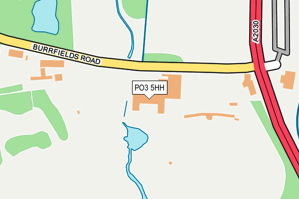
PO3 5HH is located in the Baffins electoral ward, within the unitary authority of Portsmouth and the English Parliamentary constituency of Portsmouth North. The Sub Integrated Care Board (ICB) Location is NHS Hampshire and Isle of Wight ICB - 10R and the police force is Hampshire. This postcode has been in use since June 1981.


GetTheData
Source: OS OpenMap – Local (Ordnance Survey)
Source: OS VectorMap District (Ordnance Survey)
Licence: Open Government Licence (requires attribution)
| Easting | 467259 |
| Northing | 102105 |
| Latitude | 50.814597 |
| Longitude | -1.046666 |
GetTheData
Source: Open Postcode Geo
Licence: Open Government Licence
| Country | England |
| Postcode District | PO3 |
➜ See where PO3 is on a map ➜ Where is Portsmouth? | |
GetTheData
Source: Land Registry Price Paid Data
Licence: Open Government Licence
Elevation or altitude of PO3 5HH as distance above sea level:
| Metres | Feet | |
|---|---|---|
| Elevation | 0m | 0ft |
Elevation is measured from the approximate centre of the postcode, to the nearest point on an OS contour line from OS Terrain 50, which has contour spacing of ten vertical metres.
➜ How high above sea level am I? Find the elevation of your current position using your device's GPS.
GetTheData
Source: Open Postcode Elevation
Licence: Open Government Licence
| Ward | Baffins |
| Constituency | Portsmouth North |
GetTheData
Source: ONS Postcode Database
Licence: Open Government Licence
| Portsmouth College | Baffins | 609m |
| Portsmouth College (Tangier Road) | Baffins | 631m |
| Stanley Avenue | Baffins | 636m |
| Stanley Avenue (Tangier Road) | Baffins | 672m |
| Highgrove Road (Tangier Road) | Baffins | 800m |
| Hilsea Station | 1.7km |
| Fratton Station | 2.8km |
| Cosham Station | 3.4km |
GetTheData
Source: NaPTAN
Licence: Open Government Licence
| Percentage of properties with Next Generation Access | 0.0% |
| Percentage of properties with Superfast Broadband | 0.0% |
| Percentage of properties with Ultrafast Broadband | 0.0% |
| Percentage of properties with Full Fibre Broadband | 0.0% |
Superfast Broadband is between 30Mbps and 300Mbps
Ultrafast Broadband is > 300Mbps
| Percentage of properties unable to receive 2Mbps | 0.0% |
| Percentage of properties unable to receive 5Mbps | 0.0% |
| Percentage of properties unable to receive 10Mbps | 100.0% |
| Percentage of properties unable to receive 30Mbps | 100.0% |
GetTheData
Source: Ofcom
Licence: Ofcom Terms of Use (requires attribution)
GetTheData
Source: ONS Postcode Database
Licence: Open Government Licence


➜ Get more ratings from the Food Standards Agency
GetTheData
Source: Food Standards Agency
Licence: FSA terms & conditions
| Last Collection | |||
|---|---|---|---|
| Location | Mon-Fri | Sat | Distance |
| Eastern Road Service Station | 16:15 | 11:30 | 203m |
| Quartermaine Road | 18:30 | 892m | |
| Highgrove Road | 16:45 | 11:30 | 924m |
GetTheData
Source: Dracos
Licence: Creative Commons Attribution-ShareAlike
| Risk of PO3 5HH flooding from rivers and sea | High |
| ➜ PO3 5HH flood map | |
GetTheData
Source: Open Flood Risk by Postcode
Licence: Open Government Licence
The below table lists the International Territorial Level (ITL) codes (formerly Nomenclature of Territorial Units for Statistics (NUTS) codes) and Local Administrative Units (LAU) codes for PO3 5HH:
| ITL 1 Code | Name |
|---|---|
| TLJ | South East (England) |
| ITL 2 Code | Name |
| TLJ3 | Hampshire and Isle of Wight |
| ITL 3 Code | Name |
| TLJ31 | Portsmouth |
| LAU 1 Code | Name |
| E06000044 | Portsmouth |
GetTheData
Source: ONS Postcode Directory
Licence: Open Government Licence
The below table lists the Census Output Area (OA), Lower Layer Super Output Area (LSOA), and Middle Layer Super Output Area (MSOA) for PO3 5HH:
| Code | Name | |
|---|---|---|
| OA | E00085934 | |
| LSOA | E01017014 | Portsmouth 008A |
| MSOA | E02003531 | Portsmouth 008 |
GetTheData
Source: ONS Postcode Directory
Licence: Open Government Licence
| PO3 6PW | Stanley Avenue | 645m |
| PO3 6PQ | Tangier Road | 682m |
| PO3 6PL | Stanley Avenue | 697m |
| PO3 6PN | Stanley Avenue | 710m |
| PO3 6PJ | Algiers Road | 746m |
| PO3 6PH | Algiers Road | 770m |
| PO3 6LB | Moneyfield Avenue | 777m |
| PO3 6LG | Seaton Avenue | 784m |
| PO3 6NT | Northover Road | 809m |
| PO3 6PS | Colebrook Avenue | 817m |
GetTheData
Source: Open Postcode Geo; Land Registry Price Paid Data
Licence: Open Government Licence