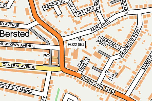
PO22 9BJ is located in the Orchard electoral ward, within the local authority district of Arun and the English Parliamentary constituency of Bognor Regis and Littlehampton. The Sub Integrated Care Board (ICB) Location is NHS Sussex ICB - 70F and the police force is Sussex. This postcode has been in use since April 1986.


GetTheData
Source: OS OpenMap – Local (Ordnance Survey)
Source: OS VectorMap District (Ordnance Survey)
Licence: Open Government Licence (requires attribution)
| Easting | 492438 |
| Northing | 100590 |
| Latitude | 50.797511 |
| Longitude | -0.689732 |
GetTheData
Source: Open Postcode Geo
Licence: Open Government Licence
| Country | England |
| Postcode District | PO22 |
| ➜ PO22 open data dashboard ➜ See where PO22 is on a map ➜ Where is Bognor Regis? | |
GetTheData
Source: Land Registry Price Paid Data
Licence: Open Government Licence
Elevation or altitude of PO22 9BJ as distance above sea level:
| Metres | Feet | |
|---|---|---|
| Elevation | 10m | 33ft |
Elevation is measured from the approximate centre of the postcode, to the nearest point on an OS contour line from OS Terrain 50, which has contour spacing of ten vertical metres.
➜ How high above sea level am I? Find the elevation of your current position using your device's GPS.
GetTheData
Source: Open Postcode Elevation
Licence: Open Government Licence
| Ward | Orchard |
| Constituency | Bognor Regis And Littlehampton |
GetTheData
Source: ONS Postcode Database
Licence: Open Government Licence
| June 2022 | Bicycle theft | On or near Central Avenue | 100m |
| June 2022 | Criminal damage and arson | On or near Central Avenue | 100m |
| June 2022 | Vehicle crime | On or near Central Avenue | 100m |
| ➜ Get more crime data in our Crime section | |||
GetTheData
Source: data.police.uk
Licence: Open Government Licence
| Shops (Chichester Road) | North Bersted | 52m |
| Shops (Chichester Road) | North Bersted | 66m |
| South Way | North Bersted | 156m |
| South Way | North Bersted | 169m |
| Van Dyck Place (Romney Broadwalk) | North Bersted | 194m |
| Bognor Regis Station | 1.5km |
| Barnham Station | 5.1km |
GetTheData
Source: NaPTAN
Licence: Open Government Licence
GetTheData
Source: ONS Postcode Database
Licence: Open Government Licence


➜ Get more ratings from the Food Standards Agency
GetTheData
Source: Food Standards Agency
Licence: FSA terms & conditions
| Last Collection | |||
|---|---|---|---|
| Location | Mon-Fri | Sat | Distance |
| Pevensey Road | 17:15 | 11:15 | 814m |
| Linden Road | 17:00 | 11:00 | 1,236m |
| Southdown Road | 17:30 | 11:30 | 1,619m |
GetTheData
Source: Dracos
Licence: Creative Commons Attribution-ShareAlike
| Facility | Distance |
|---|---|
| Arena Sports Centre Westloats Lane, Bognor Regis Sports Hall, Swimming Pool, Health and Fitness Gym, Artificial Grass Pitch, Studio, Outdoor Tennis Courts | 512m |
| Bognor Rfc Hampshire Avenue, Bognor Regis Grass Pitches | 517m |
| Laburnum Recreation Ground Durlston Drive, Bognor Regis Grass Pitches | 571m |
GetTheData
Source: Active Places
Licence: Open Government Licence
| School | Phase of Education | Distance |
|---|---|---|
| The Regis School Westloats Lane, Bognor Regis, West Sussex, PO21 5LH | Secondary | 423m |
| Southway Primary School South Way, Bognor Regis, PO21 5EZ | Primary | 465m |
| Bartons Primary School, Bognor Regis Lethaby Road, Bognor Regis, PO21 5EJ | Primary | 621m |
GetTheData
Source: Edubase
Licence: Open Government Licence
The below table lists the International Territorial Level (ITL) codes (formerly Nomenclature of Territorial Units for Statistics (NUTS) codes) and Local Administrative Units (LAU) codes for PO22 9BJ:
| ITL 1 Code | Name |
|---|---|
| TLJ | South East (England) |
| ITL 2 Code | Name |
| TLJ2 | Surrey, East and West Sussex |
| ITL 3 Code | Name |
| TLJ27 | West Sussex (South West) |
| LAU 1 Code | Name |
| E07000224 | Arun |
GetTheData
Source: ONS Postcode Directory
Licence: Open Government Licence
The below table lists the Census Output Area (OA), Lower Layer Super Output Area (LSOA), and Middle Layer Super Output Area (MSOA) for PO22 9BJ:
| Code | Name | |
|---|---|---|
| OA | E00160117 | |
| LSOA | E01031403 | Arun 012C |
| MSOA | E02006553 | Arun 012 |
GetTheData
Source: ONS Postcode Directory
Licence: Open Government Licence
| PO21 5BA | Chichester Road | 37m |
| PO22 9BX | Fairlands | 48m |
| PO21 5BE | Chichester Road | 71m |
| PO21 5AL | Chichester Road | 83m |
| PO22 9DT | Sherwood Close | 87m |
| PO22 9BT | Fairlands | 92m |
| PO22 9BW | Fairlands | 96m |
| PO21 5HQ | Newtown Avenue | 109m |
| PO21 5AJ | Royal Parade | 115m |
| PO21 5AH | Chichester Road | 118m |
GetTheData
Source: Open Postcode Geo; Land Registry Price Paid Data
Licence: Open Government Licence