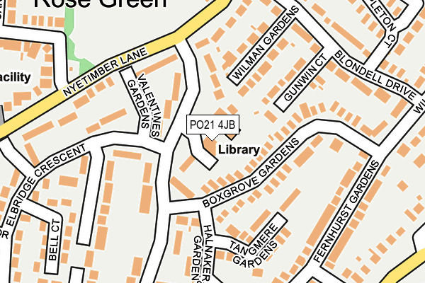
PO21 4JB is located in the Aldwick West electoral ward, within the local authority district of Arun and the English Parliamentary constituency of Bognor Regis and Littlehampton. The Sub Integrated Care Board (ICB) Location is NHS Sussex ICB - 70F and the police force is Sussex. This postcode has been in use since January 1980.


GetTheData
Source: OS OpenMap – Local (Ordnance Survey)
Source: OS VectorMap District (Ordnance Survey)
Licence: Open Government Licence (requires attribution)
| Easting | 490462 |
| Northing | 98804 |
| Latitude | 50.781766 |
| Longitude | -0.718202 |
GetTheData
Source: Open Postcode Geo
Licence: Open Government Licence
| Country | England |
| Postcode District | PO21 |
| ➜ PO21 open data dashboard ➜ See where PO21 is on a map ➜ Where is Bognor Regis? | |
GetTheData
Source: Land Registry Price Paid Data
Licence: Open Government Licence
Elevation or altitude of PO21 4JB as distance above sea level:
| Metres | Feet | |
|---|---|---|
| Elevation | 10m | 33ft |
Elevation is measured from the approximate centre of the postcode, to the nearest point on an OS contour line from OS Terrain 50, which has contour spacing of ten vertical metres.
➜ How high above sea level am I? Find the elevation of your current position using your device's GPS.
GetTheData
Source: Open Postcode Elevation
Licence: Open Government Licence
| Ward | Aldwick West |
| Constituency | Bognor Regis And Littlehampton |
GetTheData
Source: ONS Postcode Database
Licence: Open Government Licence
| January 2024 | Anti-social behaviour | On or near Grange Field Way | 413m |
| November 2023 | Violence and sexual offences | On or near Pryors Lane | 230m |
| October 2023 | Anti-social behaviour | On or near Pryors Lane | 230m |
| ➜ Get more crime data in our Crime section | |||
GetTheData
Source: data.police.uk
Licence: Open Government Licence
| Library (Pryors Lane) | Aldwick | 48m |
| Library (Pryors Lane) | Aldwick | 61m |
| Bell Court (Elbridge Crescent) | Aldwick | 203m |
| Avisford Park (Nyetimber Lane) | Rose Green | 209m |
| Avisford Park (Nyetimber Lane) | Rose Green | 214m |
| Bognor Regis Station | 3km |
GetTheData
Source: NaPTAN
Licence: Open Government Licence
GetTheData
Source: ONS Postcode Database
Licence: Open Government Licence


➜ Get more ratings from the Food Standards Agency
GetTheData
Source: Food Standards Agency
Licence: FSA terms & conditions
| Last Collection | |||
|---|---|---|---|
| Location | Mon-Fri | Sat | Distance |
| Elbridge Crescent | 17:15 | 11:30 | 318m |
| Frobisher Road | 16:15 | 11:00 | 423m |
| Rose Green Post Office | 17:15 | 11:00 | 424m |
GetTheData
Source: Dracos
Licence: Creative Commons Attribution-ShareAlike
| Facility | Distance |
|---|---|
| Avisford Park Recreation Ground Nyetimber Lane, Bognor Regis Grass Pitches | 217m |
| Rose Green Junior School Raleigh Road, Bognor Regis Grass Pitches | 525m |
| Pagham Football Club Nyetimber Lane, Bognor Regis Grass Pitches | 1.1km |
GetTheData
Source: Active Places
Licence: Open Government Licence
| School | Phase of Education | Distance |
|---|---|---|
| Rose Green Infant School Hawkins Close, Bognor Regis, PO21 3LW | Primary | 410m |
| Rose Green Junior School Raleigh Road, Rose Green, Bognor Regis, PO21 3NA | Primary | 525m |
| Nyewood CofE Junior School Brent Road, Bognor Regis, PO21 5NW | Primary | 1.8km |
GetTheData
Source: Edubase
Licence: Open Government Licence
The below table lists the International Territorial Level (ITL) codes (formerly Nomenclature of Territorial Units for Statistics (NUTS) codes) and Local Administrative Units (LAU) codes for PO21 4JB:
| ITL 1 Code | Name |
|---|---|
| TLJ | South East (England) |
| ITL 2 Code | Name |
| TLJ2 | Surrey, East and West Sussex |
| ITL 3 Code | Name |
| TLJ27 | West Sussex (South West) |
| LAU 1 Code | Name |
| E07000224 | Arun |
GetTheData
Source: ONS Postcode Directory
Licence: Open Government Licence
The below table lists the Census Output Area (OA), Lower Layer Super Output Area (LSOA), and Middle Layer Super Output Area (MSOA) for PO21 4JB:
| Code | Name | |
|---|---|---|
| OA | E00160018 | |
| LSOA | E01031385 | Arun 019A |
| MSOA | E02006560 | Arun 019 |
GetTheData
Source: ONS Postcode Directory
Licence: Open Government Licence
| PO21 4JF | Pryors Lane | 44m |
| PO21 4BB | Boxgrove Gardens | 67m |
| PO21 4JE | Valentines Gardens | 87m |
| PO21 4BD | Halnaker Gardens | 117m |
| PO21 4BE | Tangmere Gardens | 132m |
| PO21 4BW | Gunwin Court | 140m |
| PO21 4BP | Wilman Gardens | 147m |
| PO21 4LN | Willowhale Green | 162m |
| PO21 3HJ | Nyetimber Lane | 188m |
| PO21 4BA | Fernhurst Gardens | 199m |
GetTheData
Source: Open Postcode Geo; Land Registry Price Paid Data
Licence: Open Government Licence