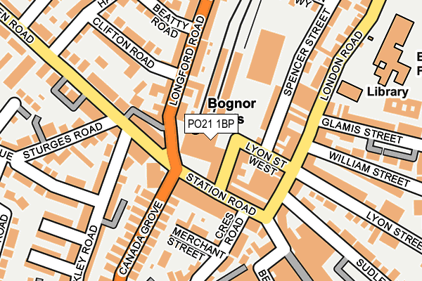
PO21 1BP is located in the Orchard electoral ward, within the local authority district of Arun and the English Parliamentary constituency of Bognor Regis and Littlehampton. The Sub Integrated Care Board (ICB) Location is NHS Sussex ICB - 70F and the police force is Sussex. This postcode has been in use since January 1980.


GetTheData
Source: OS OpenMap – Local (Ordnance Survey)
Source: OS VectorMap District (Ordnance Survey)
Licence: Open Government Licence (requires attribution)
| Easting | 493421 |
| Northing | 99387 |
| Latitude | 50.786528 |
| Longitude | -0.676073 |
GetTheData
Source: Open Postcode Geo
Licence: Open Government Licence
| Country | England |
| Postcode District | PO21 |
| ➜ PO21 open data dashboard ➜ See where PO21 is on a map ➜ Where is Bognor Regis? | |
GetTheData
Source: Land Registry Price Paid Data
Licence: Open Government Licence
Elevation or altitude of PO21 1BP as distance above sea level:
| Metres | Feet | |
|---|---|---|
| Elevation | 10m | 33ft |
Elevation is measured from the approximate centre of the postcode, to the nearest point on an OS contour line from OS Terrain 50, which has contour spacing of ten vertical metres.
➜ How high above sea level am I? Find the elevation of your current position using your device's GPS.
GetTheData
Source: Open Postcode Elevation
Licence: Open Government Licence
| Ward | Orchard |
| Constituency | Bognor Regis And Littlehampton |
GetTheData
Source: ONS Postcode Database
Licence: Open Government Licence
| January 2024 | Criminal damage and arson | On or near Parking Area | 264m |
| January 2024 | Criminal damage and arson | On or near Parking Area | 322m |
| January 2024 | Violence and sexual offences | On or near Parking Area | 322m |
| ➜ Get more crime data in our Crime section | |||
GetTheData
Source: data.police.uk
Licence: Open Government Licence
| Bognor Station (Richmond Road) | Bognor Regis | 29m |
| Bognor Station (Richmond Road) | Bognor Regis | 41m |
| Station (Longford Road) | Bognor Regis | 55m |
| Station (Longford Road) | Bognor Regis | 77m |
| Station (Linden Road) | Bognor Regis | 89m |
| Bognor Regis Station | 0km |
| Barnham Station | 5.6km |
GetTheData
Source: NaPTAN
Licence: Open Government Licence
GetTheData
Source: ONS Postcode Database
Licence: Open Government Licence


➜ Get more ratings from the Food Standards Agency
GetTheData
Source: Food Standards Agency
Licence: FSA terms & conditions
| Last Collection | |||
|---|---|---|---|
| Location | Mon-Fri | Sat | Distance |
| Linden Road | 17:00 | 11:00 | 333m |
| Argyle Road | 17:30 | 11:30 | 339m |
| High Street | 17:30 | 11:30 | 402m |
GetTheData
Source: Dracos
Licence: Creative Commons Attribution-ShareAlike
| Facility | Distance |
|---|---|
| Edward Bryant School London Road, Bognor Regis Grass Pitches | 301m |
| St. Marys Catholic Primary School Glamis Street, Bognor Regis Grass Pitches | 378m |
| Images 2 (Closed) Belmont Street, Bognor Regis Swimming Pool, Health and Fitness Gym | 415m |
GetTheData
Source: Active Places
Licence: Open Government Licence
| School | Phase of Education | Distance |
|---|---|---|
| Edward Bryant School London Road, Bognor Regis, PO21 1BG | Primary | 301m |
| St Mary's Catholic Primary School Glamis Street, Bognor Regis, PO21 1DJ | Primary | 329m |
| Bognor Regis Nursery School 85 Victoria Drive, Bognor Regis, PO21 2TB | Nursery | 413m |
GetTheData
Source: Edubase
Licence: Open Government Licence
The below table lists the International Territorial Level (ITL) codes (formerly Nomenclature of Territorial Units for Statistics (NUTS) codes) and Local Administrative Units (LAU) codes for PO21 1BP:
| ITL 1 Code | Name |
|---|---|
| TLJ | South East (England) |
| ITL 2 Code | Name |
| TLJ2 | Surrey, East and West Sussex |
| ITL 3 Code | Name |
| TLJ27 | West Sussex (South West) |
| LAU 1 Code | Name |
| E07000224 | Arun |
GetTheData
Source: ONS Postcode Directory
Licence: Open Government Licence
The below table lists the Census Output Area (OA), Lower Layer Super Output Area (LSOA), and Middle Layer Super Output Area (MSOA) for PO21 1BP:
| Code | Name | |
|---|---|---|
| OA | E00160334 | |
| LSOA | E01031444 | Arun 016B |
| MSOA | E02006557 | Arun 016 |
GetTheData
Source: ONS Postcode Directory
Licence: Open Government Licence
| PO21 1BU | Richmond Road | 18m |
| PO21 1QD | Station Road | 77m |
| PO21 2AN | Linden Road | 87m |
| PO21 1QE | Station Road | 87m |
| PO21 1XL | The Mews | 89m |
| PO21 1BY | Lyon Street West | 89m |
| PO21 1JQ | Lyon Street West | 89m |
| PO21 1AA | Longford Road | 95m |
| PO21 2AL | Linden Road | 97m |
| PO21 1AP | Spencer Street | 109m |
GetTheData
Source: Open Postcode Geo; Land Registry Price Paid Data
Licence: Open Government Licence