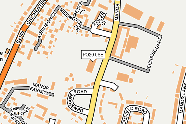
PO20 0SE lies on Manor Road in Selsey, Chichester. PO20 0SE is located in the Sidlesham with Selsey North electoral ward, within the local authority district of Chichester and the English Parliamentary constituency of Chichester. The Sub Integrated Care Board (ICB) Location is NHS Sussex ICB - 70F and the police force is Sussex. This postcode has been in use since July 2006.


GetTheData
Source: OS OpenMap – Local (Ordnance Survey)
Source: OS VectorMap District (Ordnance Survey)
Licence: Open Government Licence (requires attribution)
| Easting | 486023 |
| Northing | 93929 |
| Latitude | 50.738611 |
| Longitude | -0.782290 |
GetTheData
Source: Open Postcode Geo
Licence: Open Government Licence
| Street | Manor Road |
| Locality | Selsey |
| Town/City | Chichester |
| Country | England |
| Postcode District | PO20 |
➜ See where PO20 is on a map ➜ Where is Selsey? | |
GetTheData
Source: Land Registry Price Paid Data
Licence: Open Government Licence
Elevation or altitude of PO20 0SE as distance above sea level:
| Metres | Feet | |
|---|---|---|
| Elevation | 10m | 33ft |
Elevation is measured from the approximate centre of the postcode, to the nearest point on an OS contour line from OS Terrain 50, which has contour spacing of ten vertical metres.
➜ How high above sea level am I? Find the elevation of your current position using your device's GPS.
GetTheData
Source: Open Postcode Elevation
Licence: Open Government Licence
| Ward | Sidlesham With Selsey North |
| Constituency | Chichester |
GetTheData
Source: ONS Postcode Database
Licence: Open Government Licence
2024 28 NOV £450,000 |
2014 4 APR £318,000 |
2007 11 MAY £282,500 |
2006 31 MAY £261,851 |
GetTheData
Source: HM Land Registry Price Paid Data
Licence: Contains HM Land Registry data © Crown copyright and database right 2025. This data is licensed under the Open Government Licence v3.0.
| Selsey Centre (Manor Road) | Selsey | 28m |
| Mountwood Road | Selsey | 222m |
| Golf Links Lane (Chichester Road) | Selsey | 271m |
| Police Station (Chichester Road) | Selsey | 278m |
| Golf Links Lane (Chichester Road) | Selsey | 280m |
GetTheData
Source: NaPTAN
Licence: Open Government Licence
| Percentage of properties with Next Generation Access | 100.0% |
| Percentage of properties with Superfast Broadband | 100.0% |
| Percentage of properties with Ultrafast Broadband | 0.0% |
| Percentage of properties with Full Fibre Broadband | 0.0% |
Superfast Broadband is between 30Mbps and 300Mbps
Ultrafast Broadband is > 300Mbps
| Percentage of properties unable to receive 2Mbps | 0.0% |
| Percentage of properties unable to receive 5Mbps | 0.0% |
| Percentage of properties unable to receive 10Mbps | 0.0% |
| Percentage of properties unable to receive 30Mbps | 0.0% |
GetTheData
Source: Ofcom
Licence: Ofcom Terms of Use (requires attribution)
GetTheData
Source: ONS Postcode Database
Licence: Open Government Licence


➜ Get more ratings from the Food Standards Agency
GetTheData
Source: Food Standards Agency
Licence: FSA terms & conditions
| Last Collection | |||
|---|---|---|---|
| Location | Mon-Fri | Sat | Distance |
| East Beach Post Office | 17:00 | 12:00 | 490m |
| Drift Road | 16:50 | 11:30 | 822m |
| Hanover Close | 16:15 | 11:30 | 832m |
GetTheData
Source: Dracos
Licence: Creative Commons Attribution-ShareAlike
The below table lists the International Territorial Level (ITL) codes (formerly Nomenclature of Territorial Units for Statistics (NUTS) codes) and Local Administrative Units (LAU) codes for PO20 0SE:
| ITL 1 Code | Name |
|---|---|
| TLJ | South East (England) |
| ITL 2 Code | Name |
| TLJ2 | Surrey, East and West Sussex |
| ITL 3 Code | Name |
| TLJ27 | West Sussex (South West) |
| LAU 1 Code | Name |
| E07000225 | Chichester |
GetTheData
Source: ONS Postcode Directory
Licence: Open Government Licence
The below table lists the Census Output Area (OA), Lower Layer Super Output Area (LSOA), and Middle Layer Super Output Area (MSOA) for PO20 0SE:
| Code | Name | |
|---|---|---|
| OA | E00166598 | |
| LSOA | E01031522 | Chichester 014A |
| MSOA | E02006574 | Chichester 014 |
GetTheData
Source: ONS Postcode Directory
Licence: Open Government Licence
| PO20 0SH | Manor Road | 128m |
| PO20 0FE | Millington Drive | 131m |
| PO20 0FF | Millington Drive | 139m |
| PO20 0SJ | Denshare Road | 141m |
| PO20 0TD | St Georges Close | 151m |
| PO20 0FA | Fidler Close | 156m |
| PO20 0FD | Robinson Close | 186m |
| PO20 0LZ | Manor Farm Close | 196m |
| PO20 0FB | Petts Close | 207m |
| PO20 0PB | Broomfield Road | 218m |
GetTheData
Source: Open Postcode Geo; Land Registry Price Paid Data
Licence: Open Government Licence