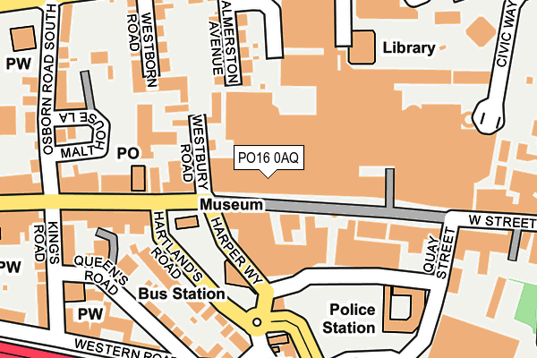
PO16 0AQ is located in the Fareham East electoral ward, within the local authority district of Fareham and the English Parliamentary constituency of Fareham. The Sub Integrated Care Board (ICB) Location is NHS Hampshire and Isle of Wight ICB - D9Y0V and the police force is Hampshire. This postcode has been in use since January 1980.


GetTheData
Source: OS OpenMap – Local (Ordnance Survey)
Source: OS VectorMap District (Ordnance Survey)
Licence: Open Government Licence (requires attribution)
| Easting | 457903 |
| Northing | 106237 |
| Latitude | 50.852760 |
| Longitude | -1.178802 |
GetTheData
Source: Open Postcode Geo
Licence: Open Government Licence
| Country | England |
| Postcode District | PO16 |
| ➜ PO16 open data dashboard ➜ See where PO16 is on a map ➜ Where is Fareham? | |
GetTheData
Source: Land Registry Price Paid Data
Licence: Open Government Licence
Elevation or altitude of PO16 0AQ as distance above sea level:
| Metres | Feet | |
|---|---|---|
| Elevation | 10m | 33ft |
Elevation is measured from the approximate centre of the postcode, to the nearest point on an OS contour line from OS Terrain 50, which has contour spacing of ten vertical metres.
➜ How high above sea level am I? Find the elevation of your current position using your device's GPS.
GetTheData
Source: Open Postcode Elevation
Licence: Open Government Licence
| Ward | Fareham East |
| Constituency | Fareham |
GetTheData
Source: ONS Postcode Database
Licence: Open Government Licence
| January 2024 | Other crime | On or near Parking Area | 186m |
| January 2024 | Violence and sexual offences | On or near Queen'S Road | 209m |
| January 2024 | Anti-social behaviour | On or near Parking Area | 258m |
| ➜ Get more crime data in our Crime section | |||
GetTheData
Source: data.police.uk
Licence: Open Government Licence
| Shopping Centre (West Street) | Fareham | 20m |
| Library (Off Osborn Road) | Wallington | 167m |
| Quay Street (West Street) | Fareham | 249m |
| Magistrates Court (Trinity Street) | Fareham | 336m |
| High Street | Fareham | 367m |
| Fareham Station | 0.9km |
| Portchester Station | 3.9km |
GetTheData
Source: NaPTAN
Licence: Open Government Licence
GetTheData
Source: ONS Postcode Database
Licence: Open Government Licence


➜ Get more ratings from the Food Standards Agency
GetTheData
Source: Food Standards Agency
Licence: FSA terms & conditions
| Last Collection | |||
|---|---|---|---|
| Location | Mon-Fri | Sat | Distance |
| Fareham Post Office | 18:30 | 12:30 | 149m |
| Fareham Post Office | 18:30 | 12:30 | 152m |
| Fareham Library | 16:45 | 12:15 | 190m |
GetTheData
Source: Dracos
Licence: Creative Commons Attribution-ShareAlike
| Facility | Distance |
|---|---|
| Sports Direct Fitness (Fareham) (Closed) Pulheim Parade, Fareham Health and Fitness Gym, Swimming Pool, Studio | 158m |
| Wykeham House School (Closed) East Street, Fareham Sports Hall | 444m |
| Fusion Fitness Gym Lysses Court, Fareham Health and Fitness Gym, Studio | 471m |
GetTheData
Source: Active Places
Licence: Open Government Licence
| School | Phase of Education | Distance |
|---|---|---|
| Harrison Primary School Harrison Road, Fareham, PO16 7EQ | Primary | 499m |
| Kingsgate School 239 West Street, Fareham, Hampshire, PO16 0HZ | Not applicable | 747m |
| Redlands Primary School Redlands Lane, Fareham, PO16 0UD | Primary | 923m |
GetTheData
Source: Edubase
Licence: Open Government Licence
The below table lists the International Territorial Level (ITL) codes (formerly Nomenclature of Territorial Units for Statistics (NUTS) codes) and Local Administrative Units (LAU) codes for PO16 0AQ:
| ITL 1 Code | Name |
|---|---|
| TLJ | South East (England) |
| ITL 2 Code | Name |
| TLJ3 | Hampshire and Isle of Wight |
| ITL 3 Code | Name |
| TLJ35 | South Hampshire |
| LAU 1 Code | Name |
| E07000087 | Fareham |
GetTheData
Source: ONS Postcode Directory
Licence: Open Government Licence
The below table lists the Census Output Area (OA), Lower Layer Super Output Area (LSOA), and Middle Layer Super Output Area (MSOA) for PO16 0AQ:
| Code | Name | |
|---|---|---|
| OA | E00115500 | |
| LSOA | E01022723 | Fareham 008C |
| MSOA | E02004734 | Fareham 008 |
GetTheData
Source: ONS Postcode Directory
Licence: Open Government Licence
| PO16 0PF | Delme Square | 33m |
| PO16 0AD | West Street | 49m |
| PO16 0AB | West Street | 105m |
| PO16 0AT | West Street | 108m |
| PO16 7US | Westbury Road | 143m |
| PO16 0BA | West Street | 148m |
| PO16 0NJ | Hartlands Road | 159m |
| PO16 7DP | Palmerston Avenue | 159m |
| PO16 0EP | West Street | 171m |
| PO16 0DU | West Street | 186m |
GetTheData
Source: Open Postcode Geo; Land Registry Price Paid Data
Licence: Open Government Licence