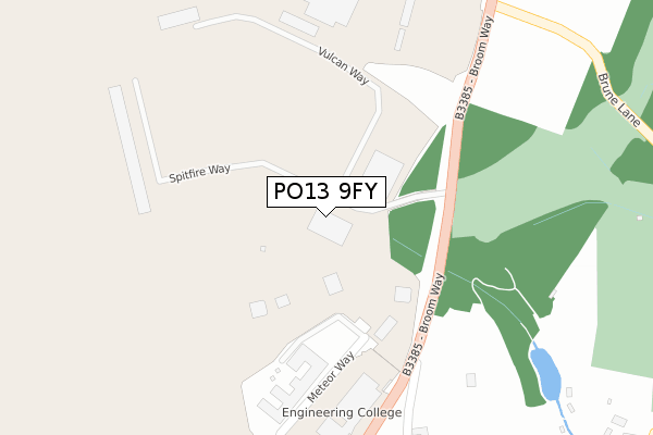
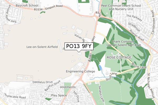
PO13 9FY is located in the Stubbington electoral ward, within the local authority district of Fareham and the English Parliamentary constituency of Gosport. The Sub Integrated Care Board (ICB) Location is NHS Hampshire and Isle of Wight ICB - D9Y0V and the police force is Hampshire. This postcode has been in use since August 2017.


GetTheData
Source: OS Open Zoomstack (Ordnance Survey)
Licence: Open Government Licence (requires attribution)
Attribution: Contains OS data © Crown copyright and database right 2024
Source: Open Postcode Geo
Licence: Open Government Licence (requires attribution)
Attribution: Contains OS data © Crown copyright and database right 2024; Contains Royal Mail data © Royal Mail copyright and database right 2024; Source: Office for National Statistics licensed under the Open Government Licence v.3.0
| Easting | 456887 |
| Northing | 102016 |
| Latitude | 50.814897 |
| Longitude | -1.193876 |
GetTheData
Source: Open Postcode Geo
Licence: Open Government Licence
| Country | England |
| Postcode District | PO13 |
| ➜ PO13 open data dashboard ➜ See where PO13 is on a map | |
GetTheData
Source: Land Registry Price Paid Data
Licence: Open Government Licence
Elevation or altitude of PO13 9FY as distance above sea level:
| Metres | Feet | |
|---|---|---|
| Elevation | 10m | 33ft |
Elevation is measured from the approximate centre of the postcode, to the nearest point on an OS contour line from OS Terrain 50, which has contour spacing of ten vertical metres.
➜ How high above sea level am I? Find the elevation of your current position using your device's GPS.
GetTheData
Source: Open Postcode Elevation
Licence: Open Government Licence
| Ward | Stubbington |
| Constituency | Gosport |
GetTheData
Source: ONS Postcode Database
Licence: Open Government Licence
| Daedalus East Gate | Peel Common | 192m |
| Daedalus East Gate (Broom Way) | Peel Common | 206m |
| Fareham Cemast | Lee-on-the-solent | 275m |
| Cherque Way (Broom Way) | Lee-on-the-solent | 343m |
| Cherque Way (Broom Way) | Lee-on-the-solent | 532m |
| Fareham Station | 4.2km |
| Portchester Station | 6.2km |
GetTheData
Source: NaPTAN
Licence: Open Government Licence
GetTheData
Source: ONS Postcode Database
Licence: Open Government Licence


➜ Get more ratings from the Food Standards Agency
GetTheData
Source: Food Standards Agency
Licence: FSA terms & conditions
| Last Collection | |||
|---|---|---|---|
| Location | Mon-Fri | Sat | Distance |
| Shoots Farm | 12:00 | 10:00 | 604m |
| The Drive | 16:45 | 11:15 | 815m |
| Fell Drive | 17:15 | 11:30 | 945m |
GetTheData
Source: Dracos
Licence: Creative Commons Attribution-ShareAlike
| Facility | Distance |
|---|---|
| Lee-on-the-solent Golf Club Brune Lane, Lee-on-the-solent Golf | 520m |
| Gosport Borough Council The Drive, Gosport Grass Pitches | 844m |
| Baycroft School Gosport Road, Stubbington, Fareham Grass Pitches, Sports Hall | 1.1km |
GetTheData
Source: Active Places
Licence: Open Government Licence
| School | Phase of Education | Distance |
|---|---|---|
| Peel Common Infant School and Nursery Unit The Drive, Gosport, PO13 0QD | Primary | 998m |
| Peel Common Junior School The Drive, Rowner, Gosport, PO13 0QD | Primary | 1.1km |
| Baycroft School Gosport Road, Stubbington, Fareham, PO14 2AE | Not applicable | 1.1km |
GetTheData
Source: Edubase
Licence: Open Government Licence
The below table lists the International Territorial Level (ITL) codes (formerly Nomenclature of Territorial Units for Statistics (NUTS) codes) and Local Administrative Units (LAU) codes for PO13 9FY:
| ITL 1 Code | Name |
|---|---|
| TLJ | South East (England) |
| ITL 2 Code | Name |
| TLJ3 | Hampshire and Isle of Wight |
| ITL 3 Code | Name |
| TLJ35 | South Hampshire |
| LAU 1 Code | Name |
| E07000087 | Fareham |
GetTheData
Source: ONS Postcode Directory
Licence: Open Government Licence
The below table lists the Census Output Area (OA), Lower Layer Super Output Area (LSOA), and Middle Layer Super Output Area (MSOA) for PO13 9FY:
| Code | Name | |
|---|---|---|
| OA | E00115754 | |
| LSOA | E01022778 | Fareham 013D |
| MSOA | E02004739 | Fareham 013 |
GetTheData
Source: ONS Postcode Directory
Licence: Open Government Licence
| PO13 9PF | Cherque Lane | 382m |
| PO13 9PA | Shoot Lane | 547m |
| PO13 9DE | Fieldhouse Drive | 551m |
| PO13 9DS | Common Barn Lane | 559m |
| PO13 8HJ | Blackbird Way | 593m |
| PO13 9DF | Falklands Close | 596m |
| PO13 9XP | Georgia Close | 648m |
| PO13 8LD | Chaffinch Way | 662m |
| PO13 8LT | Estancia Close | 692m |
| PO13 9JY | Bayntun Drive | 729m |
GetTheData
Source: Open Postcode Geo; Land Registry Price Paid Data
Licence: Open Government Licence