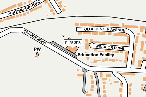
PL25 3PB is located in the Mevagissey & St Austell Bay electoral ward, within the unitary authority of Cornwall and the English Parliamentary constituency of St Austell and Newquay. The Sub Integrated Care Board (ICB) Location is NHS Cornwall and the Isles of Scilly ICB - 11N and the police force is Devon & Cornwall. This postcode has been in use since October 2002.


GetTheData
Source: OS OpenMap – Local (Ordnance Survey)
Source: OS VectorMap District (Ordnance Survey)
Licence: Open Government Licence (requires attribution)
| Easting | 204127 |
| Northing | 52275 |
| Latitude | 50.337753 |
| Longitude | -4.753894 |
GetTheData
Source: Open Postcode Geo
Licence: Open Government Licence
| Country | England |
| Postcode District | PL25 |
| ➜ PL25 open data dashboard ➜ See where PL25 is on a map ➜ Where is Carlyon Bay? | |
GetTheData
Source: Land Registry Price Paid Data
Licence: Open Government Licence
Elevation or altitude of PL25 3PB as distance above sea level:
| Metres | Feet | |
|---|---|---|
| Elevation | 60m | 197ft |
Elevation is measured from the approximate centre of the postcode, to the nearest point on an OS contour line from OS Terrain 50, which has contour spacing of ten vertical metres.
➜ How high above sea level am I? Find the elevation of your current position using your device's GPS.
GetTheData
Source: Open Postcode Elevation
Licence: Open Government Licence
| Ward | Mevagissey & St Austell Bay |
| Constituency | St Austell And Newquay |
GetTheData
Source: ONS Postcode Database
Licence: Open Government Licence
| September 2022 | Anti-social behaviour | On or near Holmbush Arch Road | 378m |
| September 2022 | Public order | On or near Holmbush Arch Road | 378m |
| September 2022 | Violence and sexual offences | On or near Kent Avenue | 405m |
| ➜ Get more crime data in our Crime section | |||
GetTheData
Source: data.police.uk
Licence: Open Government Licence
| Glebe House (Crinnis Road) | Carlyon Bay | 91m |
| Glebe House (Beach Road) | Carlyon Bay | 106m |
| Shops (Beach Road) | Carlyon Bay | 333m |
| Holmbush Inn (Holmbush Road) | Holmbush | 350m |
| Shops (Beach Road) | Carlyon Bay | 364m |
| St Austell Station | 2.5km |
| Par Station | 4km |
GetTheData
Source: NaPTAN
Licence: Open Government Licence
GetTheData
Source: ONS Postcode Database
Licence: Open Government Licence


➜ Get more ratings from the Food Standards Agency
GetTheData
Source: Food Standards Agency
Licence: FSA terms & conditions
| Last Collection | |||
|---|---|---|---|
| Location | Mon-Fri | Sat | Distance |
| The Docks | 16:45 | 07:30 | 547m |
| Charlestown Road | 16:45 | 12:00 | 630m |
| Carlyon Bay | 16:45 | 10:30 | 1,099m |
GetTheData
Source: Dracos
Licence: Creative Commons Attribution-ShareAlike
| Facility | Distance |
|---|---|
| Charlestown Primary School Crinnis Road, Carlyon Bay, St. Austell Artificial Grass Pitch | 0m |
| Wheal Eliza Trenowah Road, St. Austell Grass Pitches | 722m |
| Carlyon Bay Hotel Sea Road, Carlyon Bay, St. Austell Health and Fitness Gym, Swimming Pool, Outdoor Tennis Courts | 1km |
GetTheData
Source: Active Places
Licence: Open Government Licence
| School | Phase of Education | Distance |
|---|---|---|
| Charlestown Primary School Crinnis Road, Carlyon Bay, St Austell, PL25 3PB | Primary | 0m |
| Penrice Academy Charlestown Road, St Austell, PL25 3NR | Secondary | 1.1km |
| Bishop Bronescombe CofE School 84 Boscoppa Road, St Austell, PL25 3DT | Primary | 1.2km |
GetTheData
Source: Edubase
Licence: Open Government Licence
The below table lists the International Territorial Level (ITL) codes (formerly Nomenclature of Territorial Units for Statistics (NUTS) codes) and Local Administrative Units (LAU) codes for PL25 3PB:
| ITL 1 Code | Name |
|---|---|
| TLK | South West (England) |
| ITL 2 Code | Name |
| TLK3 | Cornwall and Isles of Scilly |
| ITL 3 Code | Name |
| TLK30 | Cornwall and Isles of Scilly |
| LAU 1 Code | Name |
| E06000052 | Cornwall |
GetTheData
Source: ONS Postcode Directory
Licence: Open Government Licence
The below table lists the Census Output Area (OA), Lower Layer Super Output Area (LSOA), and Middle Layer Super Output Area (MSOA) for PL25 3PB:
| Code | Name | |
|---|---|---|
| OA | E00096093 | |
| LSOA | E01019017 | Cornwall 036E |
| MSOA | E02003961 | Cornwall 036 |
GetTheData
Source: ONS Postcode Directory
Licence: Open Government Licence
| PL25 3PT | Gloucester Avenue | 143m |
| PL25 3QA | Windsor Drive | 145m |
| PL25 3LX | Porthmeor Road | 229m |
| PL25 3PR | Rashleigh Court | 252m |
| PL25 3PS | Gloucester Avenue | 254m |
| PL25 3LU | Porthmeor Road | 265m |
| PL25 3LT | Porthmeor Road | 266m |
| PL25 3PQ | Beach Road | 278m |
| PL25 3LS | Porthmeor Road | 304m |
| PL25 3LP | Holmbush Road | 331m |
GetTheData
Source: Open Postcode Geo; Land Registry Price Paid Data
Licence: Open Government Licence